The French Hydrographic & Oceanographic Service Orders New Maritime Drone
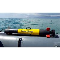
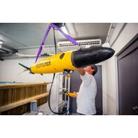
Following a seven-month bidding process, the French Hydrographic and Oceanographic Service (Shom) placed an order at the end of December for a new autonomous underwater micro-drone (μAUV), the NemoSens model, manufactured by RTsys. This order is part of a plan for hydrographic and oceanographic data acquisition methods launched by Shom in 2024.NemoSens is a micro autonomous underwater vehicle (μAUV) designed for scientific, industrial, and defense applications. It is compact at less than one meter and lightweight at less than 10 kg. Its various payload configurations allow for flexibility and
UKHO Partners with Shom to Launch International S-100 Sea Trials Program
The UK Hydrographic Office (UKHO) has launched an international sea trials program in partnership with the French Hydrographic and Oceanographic Service (Shom). The joint program represents the most comprehensive test of S-100 data standards to date and will form part of the International Hydrographic Organization’s (IHO) coordinated test bed framework. Throughout the trials, the UKHO and Shom will collect evidence to inform safety and efficiency use cases, while providing guidance on the introduction of the S-100 data framework, which is set to underpin the future of maritime navigation.
France’s Shom Selects Exail’s Drix USV Hydrographic Drone
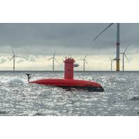
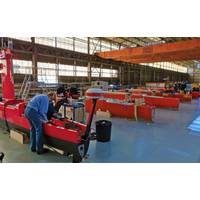
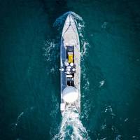
The Shom (French Naval Hydrographic and Oceanographic Service) has confirmed the acquisition of the DriX H-8 surface hydrographic drone, developed by the French robotics and maritime technologies specialist Exail.The acquisition marks a strategic milestone in the modernization of Shom’s capabilities, addressing the growing demand for reliable and certified marine data for both civilian and military purposes.The DriX H-8 will be deployed for diverse hydrographic tasks, including seabed topography, wreck detection, and seabed composition analysis.It will also play a key role in preliminary studies
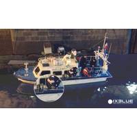
Autonomy: iXblue ramps up DriX USV Production
companies and scientific institutes for seabed mapping missions and other subsea positioning operations, including governmental institutions such as the US National Oceanic and Atmospheric Administration (NOAA), the British Antarctic Survey (BAS), the Polish Navy, the French Hydrographic Institute (SHOM), or the French Research Institute for Ocean Science (Ifremer), as well as survey contractors and operators in the energy market such as TotalEnergies, Ocean Infinity, Sulmara and other rental companies such as Unique, or WAMS.Designed to support hydrographic and geophysical surveys, water column
CASE STUDY: Nortek, Alseamar aim to make Oceanographic Data more Accessible
says.Tidal current in the Atlantic off Brittany, northwest France, over a 12-hour period, measured by the Alseamar SeaExplorer glider equipped with the Nortek ADCP glider current profiler. Source: This data was acquired in the framework of the MELANGE project (ASTRID MATURATION) in collaboration with the SHOM and the CNRS (Perpignan University)
Need a Survey? There’s a USV for That
inspection, positioning of beacons and positioning and communications with an AUV in 1,000m water depth and it can carry a wide payload suite, from MBES to integrated USBL and LBL, sub-bottom profilers and magnetometers, all within the gondola, says Eudeline.Recent DriX projects include work with SHOM, the French Navy's Hydrographic and Oceanographic service, using a launch and recovery system (LARS) on board the Beautemps Beaupré (BHO) hydro-oceanographic vessel. Reference areas down to 200m deep were surveyed, at up to <14 knots and in rough seas, with over 2,000km of survey lines
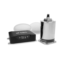
SBG Systems' INS Chosen for Shom Fleet
Shom, the French national hydrographic and oceanographic office selected SBG Systems’ inertial navigation sytems to renew their whole fleet of INS. They chose Navsight Apogee INS for their speedboats and survey vessels for both shallow and deep-water real-time bathymetric surveys and Qinertia PPK software for post-processing tasks.Shom has 3 major objectives: national hydrography and cartography, defense support in hydro-oceanographic fields, and support in maritime geospatial products and services for public policies on the sea and the coast. The fleet used by Shom is based in Brest and is
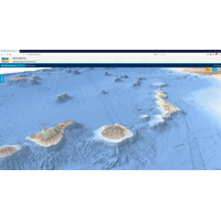
New EMODnet Bathymetry Data Product
our ability to forecast storm surges, for example.“We are proud of this new release which will help users to visualize bathymetric features with greater details. It will drastically improve their work, which relies on accessible and high quality bathymetric data,” said Thierry Schmitt from Shom (Service hydrographique et océanographique de la marine), the French Naval Hydrographic and Oceanographic Service, Coordinator of EMODnet Bathymetry.The advanced EMODnet DTM offers many benefits to users:A resolution increased from 1/8 * 1/8 arc minutes to 1/16 * 1/16 arc minutes (circa 115
iXBlue Delivers Sub-Bottom Profilers to SHOM
iXBlue, a global leader in navigation, positioning, and imaging solutions, is providing ECHOES sub-bottom profilers and DELPH seabed mapping software to SHOM for shallow water hydrographic applications. SHOM missions include ensuring safety of navigation, defense’s support and public policies such as cartographic reference. Sub-bottom profiling in shallow water always proved to be challenging for a few reasons. First, the profilers are usually towed bodies that are difficult to use when survey lines are short, U-turns are frequent and water-depth is limited. Additionally, commonly used small