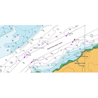
Teledyne Geospatial Automates Nautical Paper Chart Production
of nautical paper charts has been labor-intensive and time-consuming, often fraught with challenges related to manual data entry, complex chart formatting, and the integration of various data sources. Recognizing the need for a modern, technology-driven approach, CARIS AutoChart is a comprehensive software solution tailored specifically to the needs of nautical chart producers.CARIS AutoChart was formally released as part of the Australian Hydrographic Office’s (AHO) event for World Hydrography Day on June 21, 2024. The AHO has been an early adopter of CARIS AutoChart providing valuable feedback

Oceaneering and GDi Team Up for Oil and Gas Digital Asset Management
its Integrity Management and Digital Solutions group will allow the company to provide digital solutions, including a technology-focused approach to remote support, inspection, and digital asset management services.As part of the collaboration agreement, Oceaneering will utilize GDi’s Vision software solution for streamlining inspection processes.This technology allows remote assessment of external conditions, eliminating the necessity for frequent on-site physical inspections.By leveraging this remote assessment method, Oceaneering aims to optimize personnel presence on-site, leading to cost savings
Kongsberg Discovery Launches HiPOS – HiPAP Positioning Software
Kongsberg Discovery has launched a new software solution to enable remote operations of HiPAP and µPAP SSBL acoustic positioning systems, for both crewed and uncrewed survey vessels.Launched at Oceanology International in London, HiPOS – HiPAP Positioning Software for Remote Operations bridges the gap between onshore teams and vessels, allowing shore-based surveyors in remote operations control centres to operate the SSBL system with the same functionality as being offshore. Remote operations reduce HSE risk, with fewer personnel offshore, while also enabling lower operational carbon
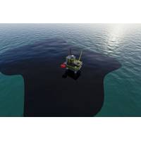
Aker BP Taps Vissim to Develop Digital Platform for Offshore Oil Spill Monitoring
The Norwegian technology firm Vissim has won a contract Vissim to develop a digital platform for future oil spill monitoring and detection system on the Norwegian continental shelf for Aker BP.Vissim said Tuesday it would develop a software solution that integrates input from a number of different oil spill detection sources, including radars, satellites, sensors, on subsea production equipment, and combine them into one, complete, easy-to-understand visual overview.Håvard Odden, director of Vissim’s North Sea operations, said: "The system will provide an integrated 24/7 real-time
NEW PRODUCT: EIVA Debuts Entry-level Hydrographic Survey Software
EIVA’s new software variant NaviSuite Kuda Core provides advanced hydrographic survey software capabilities at an entry-level price. Tailored to support hydrographic surveys with a single USV or small survey vessel using multi-beam echosounder (including backscatter), LiDAR and/or camera, this software solution is priced at €1,998 annually, designed to be simple to configure and run.In addition, it provides advanced hydrographic survey features from NaviSuite Kuda software, for example enabling autonomous operations, as it is one of several variants of this software bundle.Not only does
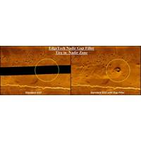
EdgeTech Debuts Nadir Gap-Fill Sonar
EdgeTech introduced a new method to provide nadir gap coverage on the EdgeTech 2205 sonar platforms. Complementing this new technology is SonarWiz from Chesapeake Technology, providing a software solution to support processing and mosaicking the new gap fill solution.The 2205 system with gap-fill technology was designed specifically for hosted platforms operating in shallow water or within close proximity to the bottom. The sonar is suited for Unmanned Surface Vehicles (USV) and Unmanned Underwater Vehicles (UUV/ AUV). The new 2205 system is available in a number of dual and tri-frequency
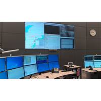
Wintershall Noordzee Deploys Wärtsilä Software to Boost Offshore Safety
are operating in the southern part of the North Sea and transiting to the major North European ports. "We, therefore, require the highest levels of safety for both the installations and the crews manning them. For this reason, we selected Wärtsilä’s Navi-Harbour WebVTS 5.0 software solution, the very latest available solution of its type, to enable analysis of alerts based on AIS information. This provides us with a sophisticated and reliable means of maintaining situational awareness," says“The system makes it possible for vessels in the vicinity of the platforms to
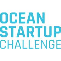
Ocean Startup Challenge Awards 14 Companies $25K Each
, which eliminates manual and error-prone processes.Virgil Group LLC (Washington, D.C.) is developing groundbreaking legal fisheries analysis software that goes beyond traceability to tackle this essential question in responsible seafood.WeavAir (Toronto, ON) provides an end-to-end hardware and software solution for vessel emission monitoring by using predictive algorithms that promote regulation compliance and operation costs savings for ship owners, ship managers and port operation teams
CMRE Open Library is Open for Business
as 1961. The communities and collections are easily searchable by subject, date, title or author.Some of the content has been available before in a variety of locations. Now the full collection has been consolidated and is available in one place. The CMRE Open Library uses the DSpace open source software solution familiar to many researchers, providing a familiar search interface either directly or through academic search engines such as Google Scholar.“The CMRE Open Library allows for better visibility of its publications and technical papers, and makes this vital knowledge available to all,&rdquo


