Kongsberg Discovery Introduces Updated SY60 Sportfishing Sonar
of situational awareness.Like the SY50, the SY60 is engineered for straightforward installation on vessels with limited space. All transceiver electronics are integrated into the transducer, reducing cabling and noise while simplifying setup. The system also supports full remote operation, automatic software updates, and optional AI‑driven target recognition. Existing SY50 users can easily upgrade to the SY60 and take advantage of these new capabilities
FarSounder Awarded Manufacturing Innovation Voucher to Advance AI‑Based Sonar Capabilities
time with performance comparable to existing classical algorithms. This foundation offers significantly greater flexibility to expand object recognition capabilities through additional training.The research supported by this award will benefit FarSounder’s existing customer base through future software updates, while also enabling new integrations across emerging maritime applications. These include pilot‑assist systems for high‑speed passenger vessels, autonomous and minimally manned platforms, advanced collision‑avoidance systems, and enhancing autonomy for USV platforms
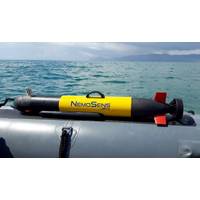
The French Hydrographic & Oceanographic Service Orders New Maritime Drone
underwater vehicle (μAUV) designed for scientific, industrial, and defense applications. It is compact at less than one meter and lightweight at less than 10 kg. Its various payload configurations allow for flexibility and maximum usability. NemoSens incorporates the latest hardware and software updates from the RTsys product line, making the micro AUV the most powerful of its generation. NemoSens is composed of four sections: a removable nose with onboard connectors for integrating different payloads; a central section including a multifunction mast (GNSS antenna, Wi-Fi antenna, UHF communication
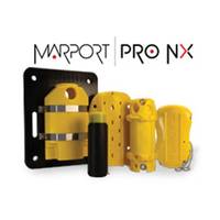
Marport Launches New Pro NX Sensor Platform
double the battery life compared to previous models, extending operational use and reducing recharge frequency.All Pro NX sensors are fully compatible with Marport’s Dock Charger, which can simultaneously charge up to four sensors, while also supporting real-time monitoring, configuration, and software updates during charging.Marport has begun shipping new Pro NX sensors listed below:Catch Pro NX: A cost-effective catch sensor for monitoring fish volume inside the codend. It offers dual-frequency support and SCALA software compatibility, but does not include echogram visualization. It’s a lightweight
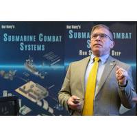
Executive Director of PEO UWS Stresses Importance of Submarines at NUWC Division Newport
part of the Pentagon's broader Combined Joint All-Domain Command and Control (CJADC2) effort.He also discussed how Team Submarine delivers a federation of independent electronics systems integrated into a common combat system, the submarine warfare federated tactical system (SWFTS). Hardware and software updates are conducted with the fleet at regular intervals, McClatchey explained, but lately there has been particular attention paid to modernizing SWFTS.McClatchey addressed some current efforts in artificial intelligence (AI) and machine learning (ML), as well. Those include Project Harbinger to provide
Golden Software updates Surfer Mapping Tech
Golden Software added the ability to download georeferenced Google aerial and satellite images to map projects in the latest version of its Surfer mapping and 3D visualization package. Other new features focus on faster and simpler creation of 3D visualizations that are easier to interpret and understand.Surfer enables users to model data sets, apply an array of advanced analytics tools, and visually communicate the results in a way that even the non-technical stakeholders can understand. Surfer is used by more than 100,000 people worldwide, many involved in environmental consulting, water resources
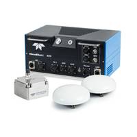
Teledyne Marine Launches Intrepid – A GNSS/Inertial Navigation System
and precise positioning.With the Intrepid on board, no manual interfacing between sensors is required, as the system automatically streams data to third-party software. This eliminates the need for manual sensor interfacing and reduces downtime.The centralized system aims to streamline firmware and software updates, providing users with effortless access to the latest features and enhancements. The new Intrepid GNSS/Inertial Navigation System combines immediate feedback with the consistent and precise results of the SeaBat T20-ASV, delivering a seamless mapping experience.The Intrepid GNSS/INS benefits
Kraken Robotics Delivers Minehunting Systems to Royal Danish Navy
DALO, with options for two further seven-year extensions, for a total possible 21 years of sustainment.The sustainment program includes regularly scheduled maintenance, repair, and overhaul as well as provision of training and spare parts, and the delivery of regular capability enhancements through software updates.Throughout 2024, Kraken will also be delivering additional spares, including spare towcables and two spare KATFISH towbodies.Kraken has developed and delivered extensive training programs with the MCM Denmark team, including Onboard Operator, Onboard Maintainer, and Depot Maintainer training
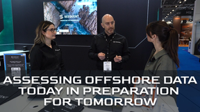
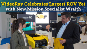
Greensea Announces Software Upgrades, VideoRay Partnership
Marine robotics technology specialist Greensea Systems Inc announces the introduction of major software updates to its OPENSEA platform add-ons, Workspace and Professional Workspace. Additionally, Greensea announces the release of EOD Workspace 6.3. These software updates are the result of collaboration with VideoRay in response to the company’s ongoing development of their Mission Specialist Series ROVs. OPENSEA, and all products developed on OPENSEA, are open architecture and support the future generation of ocean robotics through navigation, autonomy, and advanced user interface concepts