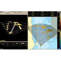
Teledyne Marine Launches Intrepid – A GNSS/Inertial Navigation System
monitor, allowing even entry-level operators to quickly set up the system and receive immediate feedback on navigational status.“Teledyne Marine’s Intrepid GNSS/INS is the next step in our line of INS products with a combined GNSS/INS system. What we have done is to integrate the SeaBat Sonar software and the Intrepid software into one software program, making it simple and easy to use for the operators,” said Pim Kuus, Senior Hydrographer and Product Manager Instruments & Imaging at Teledyne Marine
US DoE Funds Marine Energy Projects
oceanographic modeling products and low-cost, rapidly deployable monitoring solutions.Marinesitu, Washington, is working on modular instrumentation and automated data processing for marine energy monitoring. This project involves developing and demonstrating modular optical camera systems, imaging sonar software, an instrument integration hub, and an automated, cloud-based data management system to create lower-cost instrumentation and user-friendly environmental monitoring tools. These tools are based on the University of Washington’s Adaptable Monitoring Package, which has been tailored for long-term
EdgeTech Upgrades its Sonar Software
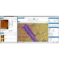
EdgeTech enhances Discover software with new coverage mapper and target logger EdgeTech, producer of high resolution sonar imaging systems and underwater technology, has released a new version of its Discover sonar software. The new software coverage mapper module has advanced navigation features allowing the setup of survey lines with a left/right steering indicator to assist in survey line control. Background navigation charts and other imagery such as multibeam bathymetry and satellite imagery can be layered or blended with individual transparency control, a feature unique to this software.
Atlas Elektronik UK Secures Cerberus Diver Detections Sonar Sales
contracts with undisclosed Middle and Far Eastern naval customers for the supply of its Cerberus DDS systems. The first contract is for the follow-on sale of a number of sonars to be utilized in the expansion of a naval harbor protection system and will feature AEUK’s fully integrated multi-sonar software which allows the simultaneous operation of multiple sonars. The second contract is with a Middle Eastern navy who has chosen Cerberus for its ability to be operated in a very challenging sonar environment, as well as full military qualification for installation on navy vessels. The system
Local History Mapping for FarSounder
on top of the system’s nautical chart display. This new overlay is displayed in conjunction with the real-time sonar overlay. When used together, one can quickly see what lies ahead and what they’ve recently passed over. LHM capabilities will be included as part of its standard navigation sonar software starting with SonaSoft 3.3. Since FarSounder 3D forward-looking sonars have a wide horizontal field-of-view ahead of the vessel, a single pass of a FarSounder sonar with LHM can survey a much wider swath of the seafloor than with a standard echosounder. In addition, the large coverage zone
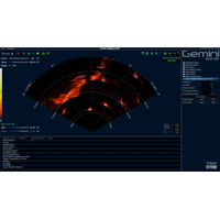
SeeByte Target Tracking for Tritech
SeeByteand Tritech International Limited [Tritech], a Moog Inc. Company, have integrated SeeByte’s target tracking capabilities into Tritech’s Gemini 720is multibeam imaging sonar software. This agreement sees the integration of Tritech’s Gemini 720is sonar with SeeByte’s advanced tracking analytics; providing users with enhanced target tracking capabilities. In realtime, users are able to track and follow objects within a wide 120deg view. This advanced feature is now available as standard with the commercial off the shelf Gemini 720is.
FarSounder Updates Navigation Sonar Software
FarSounder announced the release of SonaSoft version 3.2, an upgrade to the software which powers the FarSounder-500, FarSounder-1000, and FS-3DT sonars. This upgrade includes significant processing, user interface and display improvements. Upgrade features include: True Target Motion Chart Viewer Improvements Sonar Status Indicator Improved Color Scale Display “Our development team continues to set the standard for 3D Forward-Looking Sonars,” said Matthew Zimmerman, FarSounder’s Vice President of Engineering. “Our focus on improving
Iver3 AUV Sold to Defense Research and Development Canada
for delivery to the Defense Research and Development Canada (DRDC). The Iver3 AUV will be used to augment existing autonomous systems and provide a platform to continue R&D development in underwater research at DRDC Atlantic. OceanServer has sold several systems to DRDC with a wide range of sonar, software and sensors for research into areas such as mine counter measures. DRDC will have access to Iver’s mature hardware and software interfaces to further studies in various adaptive behavior “autonomy software” architectures. The Iver’s primary system CPU is capable
MTR Whitepapers: Call for Papers
Monitoring: Physical -- Environmental Monitoring: Chemical -- Environmental Monitoring: Biological Edition Two: Hydrography Publication Date: Jun 2015 Categories: -- Single beam -- Multi beam -- Seafloor mapping and Cartography -- Electronic charting & GIS -- Hydrographic Sonar software -- Seismic vessels -- Subsea pipeline & inspection -- Survey companies -- GPS -- Data Collection Workflow Edition Three: Unmanned Marine & Subsea Vehicles Publication Date: Nov 2015 Categories: -- Navigation Systems -- AUVs -- ROVs -- Gliders -- Unmanned Surface Vessels -