Gulf Blue Navigator Program Now Accepting Applications for Cohort 4
The University of Southern Mississippi’s (USM) Gulf Blue Navigator Program is now accepting applications for Cohort 4, which begins in January 2026. This four-month accelerator is designed to help post-pilot, blue-tech startups scale their technologies by connecting them with key partners across government, industry, and academia.Unlike traditional startup accelerators, the Gulf Blue Navigator takes a hands-on approach to foster collaboration among federal and state agencies, research institutions, and private industry. Participants gain access to state-of-the-art research facilities, wet-labs
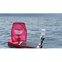
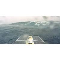
Mini USV Collects Data in a Category 5 Hurricane
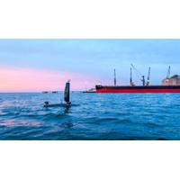
A small, wind–powered uncrewed surface vehicle (USV) captured and transmitted data from inside a Category 5 hurricane on September 28, as part of research by NOAA, the United Kingdom-based robotics company, Oshen, and the University of Southern Mississippi (USM).NOAA has teamed up with Oshen and USM to operate seven USVs called C-Stars to gather weather data from the surface of the ocean during the 2025 hurricane season.During Hurricane Humberto, one of the C-Stars became the smallest USV to gather data from the eyewall of the Category 5 hurricane. Two other C-Stars penetrated Hurricane Humberto
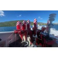
NOAA and Partners Deploy C-Star USVs to Collect Hurricane Data
NOAA, in partnership with The University of Southern Mississippi and with the robotics company Oshen, launched five small uncrewed surface vehicles (USVs) called C-Stars in the waters off the U.S. Virgin Islands on August 31st to collect critical data to better understand hurricane development and activity. The deployment is the latest effort by NOAA to advance data collection to improve hurricane research and forecasting.Two additional C-Stars will be stored in Gulfport, Mississippi, and will be ready for launch ahead of actively developing storms in the Gulf this fall.“Understanding weather
Saildrone: USVs Have Only Scratched the Surface of Maritime Security
fleets of unscrewed surface vehicles (USVs), is redefining how oceans are explored, monitored and protected.At the helm is Brian Connon, vice president of ocean mapping and a former U.S. Navy oceanographer. After leaving the Navy, Connon joined a hydrographic research center at the University of Southern Mississippi, which lead to his role at Saildrone. Now, four and a half years in, Connon has helped establish and scale up the company's ocean mapping capabilities.Saildrone sets the standardIn just over a decade, Saildrone has logged more than two million nautical miles and 50,000 days at sea, from
Kraken Robotics Banks $3m in SAS Sales
has received new orders totaling more than $3 million for Kraken Synthetic Aperture Sonar (SAS). The Kraken SAS systems will be integrated on small and medium-class uncrewed underwater vehicles (UUVs) for clients in Asia Pacific, Europe, and North America.One of the orders is for the University of Southern Mississippi’s Roger F. Wicker Center for Ocean Enterprise, which will be outfitting a variety of autonomous underwater vehicles (AUVs) and autonomous surface vessels (ASVs) with Kraken SAS to support research, development, testing, and evaluation activities.Kraken SAS integrates the capability to
Ocean Aero to Continuously Monitor the Port of Gulfport Autonomously
infrastructure in the aftermath of severe weather events. Ensuring the channel and harbor is clear for ship traffic is critical to the rapid reopening of a port following a hurricane.A key aspect of the initiative, according to Kelly Lucas, Vice President for Research at the University of Southern Mississippi, is leveraging data analysis and prediction, which USM plans to provide. “Small, nearly imperceptible changes can accumulate over time, evolving into significant issues that impact port operations. By identifying these subtle shifts early on through patterns found in the data, we
USV Hypoxia Mapping Capabilities Verified by Manned Vehicle
SeaTrac has used its SP-48 uncrewed surface vehicle (USV) to map potential hypoxic zones in the U.S. Gulf of Mexico as part of a project that confirmed its performance using data from a crewed vessel.Working in partnership with the University of Southern Mississippi (USM) and NOAA’s Office of Marine and Aviation Operations (OMAO), SeaTrac sought to prove the effectiveness of an uncrewed system in gathering real-time data in these waters, while also reducing the manpower and resources used in traditional data collection methods.Operational goals included testing and demonstrating sampling procedure
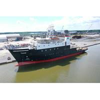
Bollinger Launches OSU's New Oceanographic Research Vessel
East Coast Oceanographic Consortium led by the University of Rhode Island. The third vessel, the R/V Gilbert R. Mason, will be based in the Gulf of Mexico. It will be managed by the Gulf-Caribbean Oceanographic Consortium, led by the Louisiana Universities Marine Consortium and the University of Southern Mississippi.The 200-foot ships are unique, with new technologies and other features to enhance operational capabilities, improve safety and expand ocean-based research. Each ship is designed to operate with 13 crew and up to 20 scientists for missions extending up to three weeks at sea.“These are
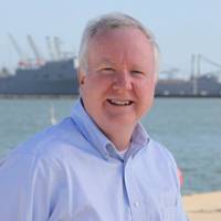
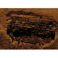
VIDEO: Up Close and Personal with Ocean Explorer Robert Ballard
clues to the unknown. Currently engaged in a $100m program with NOAA's Office of Ocean Exploration to map and characterize the US EEZ, a project which teams his ocean exploration trust with Woods Hole, the University of Rhode Island, the University of New Hampshire and the University of Southern Mississippi, Ballard has not been on the sea for nearly two years due to COVID.But Ballard – the author of multiple books, papers and articles, the subject of TV and film – took the time to take a different path of discovery and reflection, into not just his career but also his personal life