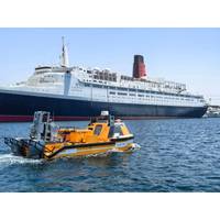
OceanAlpha Hosts First Marine USV Demonstration in the Middle East
marina with dynamic demonstrations of autonomous navigation, sensor integration, and real-time data collection.The L25 USV demonstrated its multi-sensor hub capability, integrating Teledyne Marine’s T20 Multibeam Sonar, EdgeTech Marine’s 4125 Side Scan Sonar, and Teledyne PDS software. With Trimble Centrepoint RTX signal correction, the system achieved 4 cm positioning accuracy, making it an ideal solution for complex offshore oil & gas and marine survey challenges. During dynamic trial, the vessel simultaneously executed seabed mapping, sediment analysis, underwater structure detection
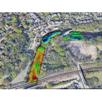
Storm Geomatics Completes Wide Swath Bathymetric River Aire Survey
survey was also completed to establish the geometry of the riverbank, foreshore, flood embankments, walls and ground behind the defences. For this part of the work Storm used a combination of the SL40 USV and traditional survey techniques, with a total station capturing a 2m grid and the use of a Trimble SX10 laser scanner. The overlapping parts of the manual and USV surveys were then cross-checked in GIS.The results of the 250m long river survey were combined to form a 3D model, drawings, and a hydraulic model in Flood Modeller Pro. This geospatial data delivery informed the engineer of the

Ocean Influencer: Mike Read, Teledyne Marine
of old and construction of new bridges is vibrant and growing.Read adds, “We continue to package and align our technologies for new and exciting emerging markets. As experts in real-time underwater vision, we’re combining our technologies and partnering with organizations such as Trimble and DSC Dredge to provide operators of heavy machinery on barges and dredges with tools to improve their efficiency and effectiveness.”Challenges AheadChallenges abound for any leader in any industry, and when Read surveys the landscape of the markets his company serves, he still sees the
Trimble Outfits New Teledyne Unmanned Survey Vessel
Teledyne Marine released a new unmanned survey vessel – the TELEDYNE Z-BOATTM 1800-T. The survey vessel will be equipped with Trimble’s GNSS heading receiver and is compatible with Trimble Marine Construction (TMC) software, enabling marine construction/dredging projects to be monitored in real time anywhere in the world.THE TELEDYNE Z-BOATTM 1800-T, designed and manufactured by Teledyne Oceanscience, is a high-resolution shallow water hydrographic unmanned survey vehicle with the newly released Odom Hydrographic Echotrac E20 Singlebeam Echosounder and dual antenna Trimble BX992 GNSS
Trimble Marine Construction Software for Positioning
The new Trimble Marine Construction Software for Positioning provides contractors with the ability to perform their own pre-/post-construction hydrographic survey.The system consists of Trimble Marine Construction software and a single beam echo sounder (SBES) for data acquisition, editing, plotting and dredge volume calculations. According to the developer, Contractors can reduce rework, increase productivity and improve site safety with a better understanding of the underwater environment.The accuracy of the waterway bed survey is the combined accuracy of the GNSS position and the echosounder
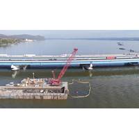
Tappan Zee Constructors ‘See’ Below the Hudson
With Trimble Marine Construction Systems and Teledyne Marine Imaging, bridge deconstruction projects can now have pinpoint accuracy.The Project @ a GlanceCustomer Profile: Tappan Zee Constructors, LLC is a consortium – including Fluor Enterprises, Inc., American Bridge Company, Granite Construction Northeast, Inc., and Traylor Bros., Inc. – that was hired to design and build the new Governor Mario M. Cuomo Bridge, one of the largest single design-build contracts for a bridge project in the United States. The project was started in January of 2013 and, after a phased opening that
French Bathymetric Survey Vessel Renovated and Refurbished
. The Bayonne vessel has been equipped with MacArtney’s multibeam solution consisting of a Kongsberg Maritime EM 2040P shallow water multibeam echo sounder, a Valeport miniSVS sound velocity sensor, an Ixblue Hydrins inertial navigation system which is a hydrographic survey INS, and a Trimble SPS 855 GNSS modular receiver combining the radio and GPS receiver in a single housing. The measures of vessel modification called for overall responsibility on the part of MacArtney France for implementing the following steps: cut the hull, create a moonpool and a blister create
Trimble to Distribute Teledyne's PDS Software
Trimble partners with Teledyne Marine to distribute its software for construction, hydrographic survey and dredging operations A new agreement will see Trimble distribute a branded version of Teledyne's PDS software package for hydrographic survey, construction and dredging operations—Trimble Marine Construction Software. The software provides measurement and positioning to improve marine construction efficiency and safety. According to Trimble, its Trimble Marine Construction Software expands its portfolio and extends its connected approach for marine construction companies to
Case Study: Mapping a Glacial Landslide
Reson T50 and a couple of seismic systems. The Z-Boat was equipped with a Teledyne Odom Hydrographic MB2 multibeam sonar and an SBG Ekinox-D INS, which gave the team Real Time Kinematic (RTK) position as well as heave, pitch, and roll of the vessel. The RTK data were being broadcast from a Trimble R10 base station that Shugar’s team brought on the excursion. Shugar’s team performed some velocity corrections and CTD measurements with an AML Oceanographic MinosX instrument. Each day, they set up a makeshift office, which was comprised of a small table with a couple of chairs set


