Satellites Help Gauge Speed of Subsurface Waves
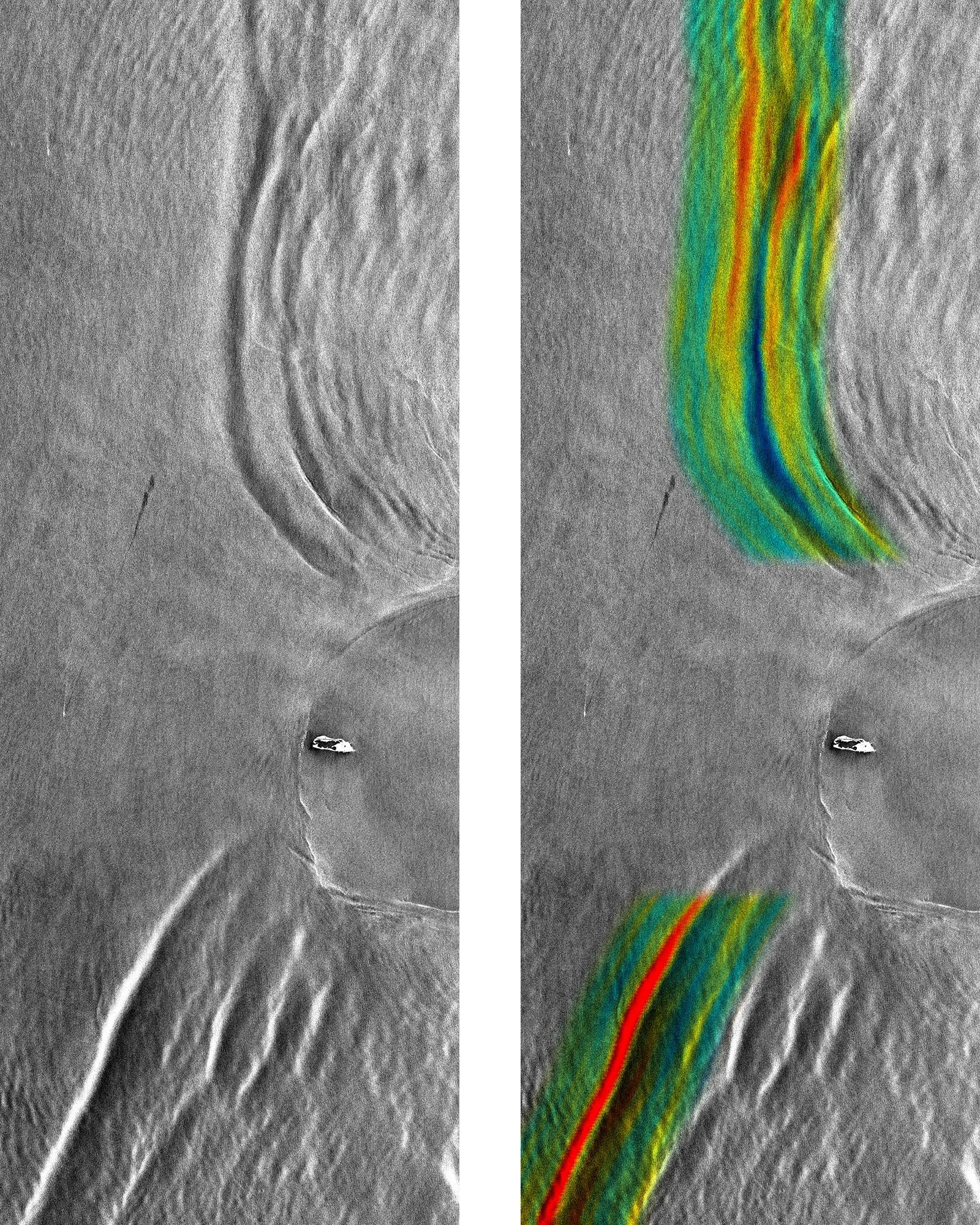
Internal waves at Dongsha Island on April 23, 2010, as seen by the radar on TerraSAR-X in its conventional mode of operation (left) and in the experimental new mode that permits direct velocity measurements (right), with the measured surface velocities shown in color. Red and blue colors indicate surface velocities of about 0.5 m/s to the left and to the right, respectively. (Images: German Aerospace Center (DLR) 2010.)
UM Rosenstiel School researchers develop new technique to measure speed of waves below ocean surface
The speed of a wave located 80 meters below the ocean’s surface has been measured directly from a single satellite image.
The new technique developed by researchers from the University of Miami (UM) Rosenstiel School of Marine and Atmospheric Science advances the study of these skyscraper-high internal waves that rarely break the ocean surface.
“This is the first time internal wave velocities could be calculated from data acquired during a single overpass of a satellite,” said Roland Romeiser, associate professor of ocean sciences at the UM Rosenstiel School. “This allows us to obtain more accurate information from a satellite that we could in the past.”
Using a single satellite image collected at UM’s Center for Southeastern Tropical Remote Sensing (CSTARS), the research team was able to determine that a roughly 60-meter high internal wave was traveling at a speed of three miles per hour (1.4 meters per second) near Dongsha Island in the South China Sea. The region is considered to have some of the most powerful internal waves on the planet.
“This is a significant breakthrough using a single image to determine the velocity of a wave below the surface,” said Hans Graber, UM Rosenstiel School professor of ocean sciences and director of CSTARS. “This technology offers new opportunities to track the speed of ocean currents or objects moving on or below the ocean surface.”
Radar satellites can detect the surface ripples produced by internal waves and the data collected allow researchers to calculate the speed of internal waves traveling below the surface. Prior to the development of this new technology, researchers would have to compare several images taken during multiple satellite overpasses to estimate internal wave velocities. The radar affixed to the German satellite TerraSAR-X is the first to measure velocities directly during a single overpass but with significant noise. Romeiser and Graber developed a new method to process the data that enhances the internal wave patterns to extract the velocities with unprecedented accuracy. CSTARS is the only place besides the German Aerospace Center (DLR) that is capable of processing these types of images.
Internal waves move huge volumes of heat, salt and nutrient rich-water across the ocean, which is important to fish, industrial fishing operations and the global climate. In addition, they are important to monitor for safe surface and sub-surface marine operations.
Graber was part of an international research team that spent seven years tracking the movements of internal waves to understand how these waves develop, move and dissipate underwater. The team discovered that internal waves are generated daily from internal tides, which also occur below the ocean surface, and grow larger as the water is pushed westward through the Luzon Strait into the South China Sea. Their findings were published in the May 7 issue of the journal Nature.
A research team led by Romeiser was the first to accurately measure currents from a space shuttle platform between islands off the Dutch coast and the first to make current measurements using the radar on the TerraSAR-X satellite.
The study, titled “Advanced Remote Sensing of Internal Waves by Spaceborne Along-Track InSAR—A Demonstration With TerraSAR-X,” appears in the Dec. 2015 issue of the journal Transactions on Geoscience and Remote Sensing, a publication of the Institute of Electronic and Electrical Engineers (IEEE). The study’s authors are Roland Romeiser and Hans Graber of the UM Rosenstiel School. The work was supported by grants from the U.S. Office of Naval Research.