Marine Technology News Search
Search term • "advanced navigation"
Create an email alert for "advanced navigation"

Fugro Nets Offshore Namibia Survey Contract
The Portuguese oil and gas firm Galp has awarded the Dutch company Fugro a contract to conduct an environmental and geophysical survey offshore Namibia. "Known for its remote location, challenging conditions and ultra-deep water, this site is key to future energy operations in the region. Fugro's advanced technology and expertise in marine geophysical and environmental surveys ensured efficient and accurate data collection…
KVH Intros Digital Crew Welfare Solution
KVH Industries, a provider of mobile connectivity and inertial navigation systems, has introduced a new digital content service called KVH Link to help shipowners, operators and managers provide rest-time entertainment for seafarers and increase onboard productivity.KVH Link provides timely and popular news, sports, movies, TV, music, karaoke, podcasts, documentaries, trending social videos, in the…

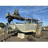
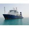
Fugro Expands Geotechnical Vessel Fleet
Dutch offshore survey company Fugro has expanded its geotechnical vessel fleet with the Fugro Quest vessel. According to Fugro, the vessel is equipped with advanced deep-water technology."Fugro uses this type of vessel to determine the exact composition of the soil; the resulting data are essential to establish the optimal location and design of offshore developments, such as wind farms," Fugro explained.The…
Voyis Imaging Chosen as the Camera Package for HII REMUS Vehicles
HII has selected Voyis Imaging Systems as the standard camera option for all REMUS UUVs (REMUS 100/300/620/6000). Voyis has developed the Recon UUV module, consisting of a highly advanced 4K stills camera and extremely efficient, high output external light bar, that enhances all REMUS platforms imaging capabilities in any operational situation. The Recon camera module offers extremely crisp stills imagery with on-the-sensor data processing for real-time…
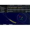
Port of Sunderland Selects PicoMB Multibeam Technology for Port Surveys
Port of Sunderland has chosen the PicoMB 130Surf integrated echosounder (Pico MB-130 with integrated Applanix POSMV SurfMaster), having witnessed the success of Port of Blyth in completing surveys since their purchase of a PicoMB Multibeam four years ago. They recently took delivery of the system from Geodesea Ltd.The PicoMB-130 facilitates high resolution surveys on man-portable USVs and small survey vessels.
Scana's Subseatec Wins 'Sizeable' Riser Joints Order
Scana's Subseatec has won a contract with an international energy company for the delivery of riser joints. The joints are intended for an offshore field development. Scana said the deal was a sizeable contract for the company, meaning it is worth between NOK 10 million and NOK 50 million.Subseatec’s scope is a delivery of ready-to-use riser joints in low alloyed steel, including engineering, manufacturing, procurement, and documentation.
Racing to the Bottom: Seabed Warfare Brings Threats, Opportunities
In the early morning hours of September 26, 2022, seismologists located throughout northern Europe detected two disturbances originating in the Baltic Sea that were consistent with underwater explosions. Within hours, an aerial image captured by a passing Danish F-16 showed an expanse of frothy seawater, suggesting that the Nord Stream 1 and Nord Stream 2 gas pipelines had experienced a catastrophic event.

Divers Find Deepest Known Shipwreck USS Johnston
A privately funded mission has found, surveyed and filmed the USS Johnston, the world’s deepest known shipwreck, offshore Samar Island in the Philippines Sea.The expedition was backed by Victor Vescovo, is an entrepreneur, explorer and retired U.S. Navy Commander who personally piloted his submersible DSV Limiting Factor down to the wreck during two separate, eight-hour dives 21,180 feet (6,456 meters) below the ocean's surface.
DOE Seeks Input on Mooring & Anchoring Systems for Floating Wind
The U.S. Department of Energy is seeking input on research needs related to floating offshore wind energy mooring and anchoring systems. For this, DOE's Wind Energy Technologies Office (WETO) has issued a Request for Information (RFI).Apart from input on research priorities, DOE is seeking information on state-of-the-art innovative technologies, state-of-the-practice common operations, and aspirational targets to help meet deployment goals…
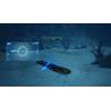
Oceaneering's Hybrid AUV/ROV Achieves TRL 6 For Pipeline Inspection
Subsea services and technology specialist Oceaneering said Monday that its Freedom AUV, has achieved Technology Readiness Level 6 on a 1-9 scale.Oceaneering said that its Freedom, a hybrid AUV/ROV system, is the result of a long-term collaborative relationship between Oceaneering, TotalEnergies, and Chevron dating back to 2014, with Equinor joining the collaboration in 2019. In 2014, Oceaneering began efforts to optimize the delivery of a pipeline inspection service from an AUV.

VideoRay Acquires Blue Ring Imaging
VideoRay has acquired Blue Ring Imaging, a St. Petersburg, FL-based innovator in 3D visualization, multi-view perception, and simulation for unmanned systems.Blue Ring Imaging, known for its OctoView mixed reality software and OctoCAM multi-view 360°camera, will improve situational awareness and object detection capabilities of VideoRay's Defender. Blue Ring Imaging already boasts an impressive client list…
First in Middle East: Aramco’s Survey Vessel Gets ABS' Infectious Disease Mitigation Notation
Aramco’s hydrographic survey vessel, KARAN 8, has become the first in the Middle East region and second worldwide to be awarded an ABS Infectious Disease Mitigation (IDM) notation.ABS' IDM-A notation is offered to vessels that meet the arrangement requirements addressing the configuration of spaces that can be used for the isolation and segregation of crew, passengers, and onshore visitors, as well…
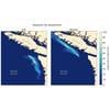
NOAA: Operational Forecast System Informs Shipwreck Oil Spill Scenarios
During World War II, the 334-foot, 5,350-ton SS Coast Trader was hit by a torpedo and sank off the coast of Cape Flattery, Washington. Resting almost 500 feet below the surface, the Coast Trader has an estimated 542 tons of heavy fuel oil remaining in the fuel tanks. The quantity onboard the Coast Trader is equivalent to 60% of the volume of fuel spilled into the Pacific Ocean near Grays Harbor by the barge Nestucca in 1988…
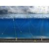
CGG's Sercel Buys ION Geophysical's Software Business
French seismic data firm CGG said Monday that its Sensing & Monitoring division Sercel had completed the acquisition of ION Geophysical Corporation’s (“ION”) software business.ION's software business includes Orca: a navigation system dedicated to streamers; Gator: a navigation system dedicated to OBN; Mesa: a set of tools for optimizing land and marine seismic crews; and Marlin: a software for managing simultaneous marine operations…
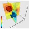
Golden Software updates Surfer Mapping Tech
Golden Software added the ability to download georeferenced Google aerial and satellite images to map projects in the latest version of its Surfer mapping and 3D visualization package. Other new features focus on faster and simpler creation of 3D visualizations that are easier to interpret and understand.Surfer enables users to model data sets, apply an array of advanced analytics tools, and visually communicate the results in a way that even the non-technical stakeholders can understand.

Kongsberg Maritime Launches 'Digital Toolbox' for Ocean Data Management, Analysis
Kongsberg Maritime (KM) launched Blue Insight, a cloud-based digital toolbox designed to enable collection, visualization, contextualization, management and distribution of ocean data. According to KM, Blue Insight provides an open, modular platform for the processing, visualization and sharing of ocean data. The core module contains the cloud framework – which has been built to the highest cyber security standards – and an application-specific dashboard…

Carnegie Launches Wave Energy Device to Power Moored Vessels
ASX-listed wave energy technology company Carnegie Clean Energy has launched a CETO-derived wave energy product designed for moored vessels, which "offers a solution to the challenge of securing clean and reliable energy for offshore activities, reducing reliance on diesel generation."CETO is a fully submerged, point absorber-type wave energy technology. A submerged buoy sits a few meters below the surface of the ocean and moves with the ocean’s waves.

Global Hydrographic Innovation and Technology Laboratory Established in Singapore
Singapore and the International Hydrographic Organization (IHO) have launched the Joint IHO-Singapore Innovation and Technology Laboratory.The Laboratory seeks to optimize the resources of IHO Member States to harness and develop emerging technologies in the hydrographic domain that support safe maritime navigation and the protection of the marine environment. In accelerating innovation in the field of hydrography…
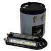
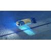
ION Sells Compasses for Subsea Vehicle Navigation
ION announced today the second sale of a number of its highly differentiated optical magnetic heading sensors to enable subsea vehicles to quickly reach their desired destinations.In the fourth quarter, successful field trials demonstrated the advanced compasses’ accuracy in GPS-deprived environments and led to delivery of the first commercial order in the first quarter.In less than a year, ION's devices…
Shell Starts New Gulf of Mexico Field ahead of Plan
Royal Dutch Shell on Thursday announced the start of production at the Kaikias field in the U.S. Gulf of Mexico, around one year ahead of schedule.Production from the subsea deep water development, which will reach 40,000 barrels of oil equivalent per day, comes after Shell reduced its costs by around 30 percent to allow it to generate profit at less than $30 a barrel, the company said."We believe…


