
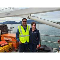
Aker Solutions, Kongsberg Discovery Partner on Offshore Drone Detection
technologies across the North Sea to bolster situational awareness around energy assets and transit lanes.Kongsberg Discovery develops navigation, acoustic and marine robotics systems, including autonomous underwater and surface vehicles, and offers products such as Drone Detection Radar, Mobile Broadband Radio, camera clusters and subsea acoustic monitoring tools.Aker Solutions, which provides integrated low-carbon oil and gas solutions and supports renewables such as offshore wind, hydrogen and carbon capture, will act as system integrator, with Kongsberg as sub-supplier.Later phases of the program

Kongsberg Discovery Receives U.S. DoD Certification for MBR Communication System
Kongsberg Discovery announced that its Mobile Broadband Radio (MBR) MK3 series has received DD1494 certification from the United States Department of Defense (DoD), authorizing the systems for use across U.S. military operations.The DD1494 approval confirms that the MBR MK3 series, operating in the frequency range between 4.400-5.000 GHz (Nato Band IV), meets the DoD’s requirements for spectrum-dependent equipment. This certification ensures the systems can operate within designated frequency bands without interfering with other military or government communications systems, while providing

Ocean Networks Selects Prysmian, International Telecom for Hawaiian Islands Fiber Link (HIFL)
IT International Telecom Inc. (IT) for the Hawaiian Islands Fiber Link (HIFL) project. This collaboration marks significant progress in the development of Hawaiʻi’s open-access, carrier-neutral inter-island fiber infrastructure, designed to dramatically improve and expand high-speed broadband internet throughout the state.The HIFL project, a key component of the State of Hawaiʻi’s "Connect Kākou" broadband initiative, aims to deliver robust and resilient digital connectivity across the Hawaiian Islands. Under the agreement, Prysmian will supply approximately 740 kilometers
Pioneer Consulting Completes Submarine Cable Marine Route Surveys in Alaska
run 300km between Cordova and Seward, and FISH South, which will run 900km between Cordova and Juneau. Funded by the U.S. Department of Agriculture’s ReConnect Program, an initiative to provide connectivity to rural and underserved communities, the FISH projects will bring critical high-speed broadband service to Cordova, Johnstone Point, Chenega, Yakutat, Hoonah, Pelican, and Gustavus—some of Alaska’s most remote regions.Pioneer Consulting has worked alongside Cordova Telecom Cooperative Inc. since 2022 with an initial feasibility study and will continue to spearhead project activities
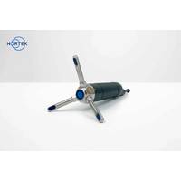
Nortek Launches Generation 2 Vector Velocimeter
the instrument to communicate via both Ethernet and serial using a single cable. Finally, following Nortek’s tradition, the Generation 2 Vector offers an LED which blinks at the user-defined sampling rate while collecting data, providing peace of mind during deployment.Modern electronics and broadband processing improve the instrument’s precision for agiven power consumption, making longer deployments possible on the same amount ofbattery power.A short-range echosounder has also been added, enabling users to image structures in thewater column. This is especially useful to those investigating

Nokia's Subsea Optical Solution Powers Boosts Interconnectivity in Indonesia
PT Solusi Sinergi Digital Tbk (Surge), a digital infrastructure provider in Indonesia, has deployed Nokia’s subsea optical solution to connect Jakarta and Singapore. This new subsea network will boost regional data center interconnectivity and support Surge’s mission to expand affordable broadband access to underserved communities across Indonesia.The new high-capacity subsea connection is part of Surge’s broader infrastructure expansion to extend fiber-based broadband to 40 million households. It will enable Surge’s affordable internet initiatives, bringing reliable connectivity

WHOI: New Discovery Reveals Sharks May Detect and Produce Sound
when approached by divers. Both ray species belong to the ancient elasmobranch family, a class of cartilaginous fish with distinctive anatomical features. Recently, three other related species, including the blonde ray, the rough skate, and the marbled electric ray, were also reported to produce short, broadband clicks when disturbed by divers, possibly as a threat response. Tracing these evolutionary transitions that go back 450 million years, researchers began to suspect that sharks may be capable of similar sound production.Whether rig sharks can acoustically sense their own click sounds, or what function
Sercel Launches DFU-3C Node, Extending WiNG Range
.The new integrated three-component node acquires the most comprehensive and high-definition data for outstanding imaging, characterization and monitoring of the subsurface. As part of the WiNG range, it comes complete with unique advanced features as standard, such as the ultra-sensitive QuietSeis® broadband digital sensor and Pathfinder transmission management technology. Combined with its market-leading compact and lightweight design, the DFU-3C offers unprecedented precision, efficiency and portability."Building on the success of our widely used WiNG single-component node, this three-component
GeoAcoustics to Launch Two New Side Scan Sonars at Ocean Business
GeoAcoustics Ltd will debut a new Side Scan Sonar range at Ocean Business 2025 next week, adding to its hydroacoustic technology portfolio.Designed to deliver superior visualization for diverse marine survey applications, the GeoScan range currently features two models, both offering simultaneous broadband dual frequency operation and advanced sonar processing features.The GeoScan 2361 operates at 300 kHz and 600 kHz to maximize range performance, while the GeoScan 2491 runs at 400 kHz and 900 kHz to deliver even higher image resolution. Both include a fast 60 kHz update rate, CW and Chirp pulse