Fascinated by Shipwrecks Podcast: USS Constitution - Still on Duty
the underwater world, his thesis, and how technological advances like augmented reality are changing the way the public can interact with shipwrecks.About Ryan MirandaRyan Miranda is a maritime archeologist and historian with a master's in Maritime studies from East Carolina University. From the Chesapeake Bay to the shores of Costa Rica and the Gulf Coast of Texas, his career has allowed for diverse experiences in underwater research and cultural resource management. His interest in emerging technologies focuses on technologies to improve the public's knowledge about maritime archeology and the
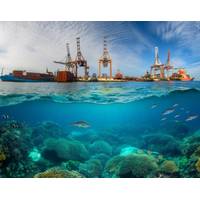
Restoring Marine Habitats and Port Decarbonization
provision of food and livelihoods for coastal communities. Several marine restoration projects have achieved remarkable success in recent years, showcasing the potential for positive outcomes and significant carbon sequestration potential [19,20,21]. In the United States, oyster reef restoration in Chesapeake Bay has improved water quality and biodiversity [22]. These projects highlight the benefits of dedicated restoration efforts, which can act as catalysts for positive change and provide valuable insights for future projects. Through restoring and protecting marine ecosystems, as well as engaging with
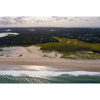
The Potential of Restoring Marine Habitats
provision of food and livelihoods for coastal communities. Several marine restoration projects have achieved remarkable success in recent years, showcasing the potential for positive outcomes and significant carbon sequestration potential [19,20,21]. In the United States, oyster reef restoration in Chesapeake Bay has improved water quality and biodiversity [22]. These projects highlight the benefits of dedicated restoration efforts, which can act as catalysts for positive change and provide valuable insights for future projects. Through restoring and protecting marine ecosystems, as well as engaging with

PODCAST: “All in the [Gallaudet] Family”
went to the Naval Academy, commissioned to become an oceanography officer in the US Navy. What was great about that career path in the Navy is you get exposed to ocean technologies from the very beginning. Even at the Naval Academy, we were using side-scan sonar to do surveys and collect data in the Chesapeake Bay.My first tour was going to graduate school at Scripps where I worked with multibeam sonar and satellite imagery. I went on a few cruises on a couple of Scripps ships, and then I immediately deployed to the Arabian Gulf and worked on a hydrographic survey ship, towing side-scan sonar and operating
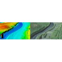
USGS : New Topobathymetric Dataset for Potomac River
Teledyne Geospatial said the U.S. Geological Survey (USGS) and Dewberry, a privately held professional services firm, published a new topobathymetric lidar dataset for the Potomac River. The Potomac River flows from the Potomac Highlands in West Virginia to the Chesapeake Bay in Maryland. The lidar survey was conducted for USGS’s 3D Elevation Program (3DEP), with stakeholders including the USGS Earth Resources Observation and Science Center (EROS), National Geospatial Program (NGP), and Eastern Ecological Science Center (EESC) programs, as well as the Interstate Commission on the Potomac
US Awards $6.7 Million for Sea Level Rise and Coastal Resilience Research
in Los Angeles County, California.(IRA-funded) George Mason University, The Nature Conservancy, Resources for the Future and Maryland Department of Natural Resources received nearly $500,000 to evaluate flood mitigation designs under future climate scenarios to inform restoration efforts in the Chesapeake Bay region.University of Texas at Arlington and University of Arkansas received nearly $500,000 to evaluate how different shoreline adaptation actions perform with sea level rise and storms in California.University of Rhode Island and Penn State University received over $360,000 to assess how nature-based
US Marine Economy Worth $432 Billion in 2021
statistics from the annual Marine Economy Satellite Account released by two Department of Commerce agencies —NOAA and the Bureau of Economic Analysis (BEA). The marine economy statistics include activities in the US ocean, coasts and major water bodies such as the Great Lakes, Puget Sound and Chesapeake Bay.From 2020 to 2021, the marine economy bounced back strongly from declines associated with the COVID-19 pandemic, with a 7.4% growth in GDP and a 10.5% growth in sales. The growth in the marine economy outpaced U.S. economic growth, which had a 5.9% growth in GDP and 6.2% growth in sales.&ldquo
NOAA Taps Woolpert for Chesapeake Bay Watershed Study
Woolpert announced it has been selected by the National Oceanic and Atmospheric Association (NOAA) to perform hydrographic surveying and collect bathymetric data for hydrodynamic modeling in the Chesapeake Bay Watershed. The $5.5 million award with a $1.4 million option, funded in part by the bipartisan Infrastructure Investment and Jobs Act, is being administered through NOAA’s Office of Coast Survey hydrographic services contract.This project will focus on 615 square nautical miles and include portions of the Potomac, Rappahannock, James, and York rivers, which in some areas have not been
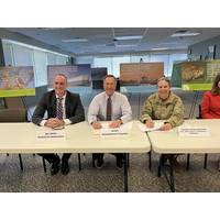
Army Corps, Maryland DOT to Commence $4 Billion Chesapeake Bay Restoration Project
The U.S. Army Corps of Engineers (USACE), Baltimore District, and the Maryland Department of Transportation (MDOT) signed a Project Partnership Agreement (PPA) for the $4 billion Mid-Chesapeake Bay ecosystem restoration project at MDOT Headquarters, August 23, 2022.The PPA – signed by Col. Estee Pinchasin, Baltimore District commander, and MDOT Secretary James F. Ports, Jr. – outlines the roles, responsibilities, and financial obligations for both partners for the restoration of both James and Barren islands in Dorchester County, beneficially re-using material dredged from the Port of