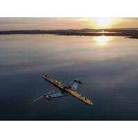
Orbital Marine Gets LR Certification for O2-X Tidal Energy Turbine
, Scotland, the O2-X is expected to generate 2.4MW of predictable, renewable energy from tidal flows.With plans for deployment in the U.K., Canada, and the U.S., Orbital aims to scale up tidal energy as a reliable source of zero-emission power, potentially integrating with offshore operations, coastal infrastructure, and maritime electrification projects.As the only renewable energy certification body (RECB) with a scope in marine energy, LR has been working closely with Orbital to ensure the O2-X meets required international standards.This certification process is essential to enable international trade
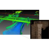
Teledyne to Debut New Marine Lidar Sensor for USVs
resolution multibeam systems and the CARIS Ping-To-Chart workflow, allowing for full above and below water image capture with survey grade accuracy in a single workflow. The sensor’s 360-degree scanner and up to 2 million points/second collection rate provides a premier solution for mapping coastal infrastructure. The CL-360 is the only lidar system designed for use on a USV (uncrewed surface vessel) which provides survey grade range and accuracy.Find out about the new HIPS & SIPS 11.4 release, now with sound speed and vertical correction mode available for the first time as a SaaS licensing option
WHOI Receives $2 Million from State for CWATER Project
in ocean science, marine operations, and the blue economy.”Secondly, an amendment sponsored by Rep. Fernandes in the House and Senator Moran in the Senate secured $1 million to restore the Marine Biological Laboratory’s Waterfront Park seawall. The seawall is an essential piece of coastal infrastructure that enables the use of the scenic public recreational space overlooking Great Harbor and protects downtown Woods Hole from flood risks. It also serves as a vital link in the MBL’s seawater intake system for maintaining marine organisms.Coastal storms have damaged the seawall and undermined
MMA Offshore to Buy Rigs-to-Reefs Specialist Subcon for $8.4M
Australian offshore support vessel owner MMA Offshore has agreed to buy Perth-based Subcon, a company that provides innovative stabilization, coastal erosion, and engineered reef solutions to the oil and gas, offshore wind, coastal infrastructure, and tourism sectors.The total consideration for the transaction is $8.4 million comprising $4.2m cash and $4.2m in MMA ordinary shares."The acquisition is aligned with MMA’s purpose and strategy bringing a range of new environmental marine solutions within MMA’s capability," MMA Offshore said."Subcon has averaged revenue of approxima
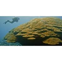
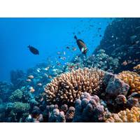
Record-sized Coral Colony Discovered in American Samoa
slightly larger than the state of Rhode Island, they provide billions of dollars annually in food, jobs, recreation and tourism, and coastal protection. A U.S. Geological Survey study determined coral reefs annually provide flood protection to more than 18,000 people and $1.8 billion worth of coastal infrastructure.NOAA’s National Marine Sanctuary of American Samoa is the largest American marine sanctuary and protects 13,581 square miles of shallow water coral reefs and open water.NOAA’s Coral Reef Conservation Program awards at least $8 million annually in grants and cooperative agreements
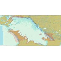
Fugro to Deploy Latest RAMMS Tech to Map Lake Huron
growth markets related to energy transition and climate impact mitigation. For Lake Huron, the innovative technology will enable efficient and accurate data acquisition, despite multiple site-related challenges, including extensive areas of shallow water, complex coastlines, and relatively sparse coastal infrastructure.“The system’s unique design delivers high resolution data and penetrates to water depths that meet both the demands of this survey and the specifications required for nautical charting products,” said Mark MacDonald, Hydrography Director for Fugro in the Americas
Oi Americas Set for San Diego
most comprehensive program to date.On the opening day of the show, Monday, 25 February 2019, the one-day Ocean Futures Forum (new to OiA) will comprise a series of presentations and panel discussions examining anticipated issues, requirements and developments relating to aquaculture, ocean and coastal infrastructure protection, offshore marine renewable energy and the overall Blue Economy. Confirmed presenters include Wendy Watson Wright, CEO, Ocean Frontier Institute; Plenary Co-Chair Rick Spinrad, President, Marine Technology Society (MTS); and Jason Giffen, Assistant Vice President, Planning &
NSF Grant to Enhance Satellite-derived Bathymetry Technology
techniques by leveraging machine learning and computer vision technology to enable accurate depth retrieval in variable water conditions.If successful, TCarta said, these enhanced bathymetric techniques will have positive impacts on operations related to oil and gas exploration and production, coastal infrastructure engineering, environmental monitoring, and geointelligence (GEOINT) activities.“Our goal with Project Trident is to expand the geographic scope of SDB in shallow coastal areas,” said Kyle Goodrich, TCarta President. “SDB technology currently derives water depths only in
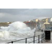
NOC Predicts Increase in Extreme Sea Levels
A new study has predicted that future global warming will lead to an increase in ‘extreme sea levels’, with consequent flood risks to coastal infrastructure and human populations. Extreme sea levels occur through a combination of high tides and extreme weather events, which can generate storm surges and high wind waves. These incidents are intensified by gradual rises in mean sea level and predicted increases in tropical cyclone activity. Researchers have taken all these factors into account to assess future risks of extreme sea levels up until the year 2100. The National Oceanography


