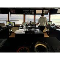
Polar Research Vessel Gets Nav System Refit
control of all functions from any workstation. The multifunctional system ensures a consistent user experience with harmonised data, alerts and terminology—reducing distractions and supporting clear situational awareness. The INS integrates radar systems, precision autopilots and a redundant gyro compass system.The RRS Sir David Attenborough is owned by the Natural Environment Research Council and operated by the British Antarctic Survey for both scientific research and logistical support.Image copyright Jenna Plank – BA
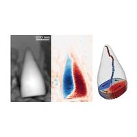
Magnetic Fossils May Reveal Eels’ Internal GPS System
navigation guidance.While some migratory animals including birds, fish and insects are thought to use Earth's magnetic field to navigate, how they manage this remains unanswered. One hypothesis is that magnetite particles inside their bodies align with Earth's magnetic field, akin to a compass needle.Identifying the creature to which the fossils may have belonged remains a challenge as they were not associated with any other bodily remains.It would make sense, the researchers said, if they came from a migratory animal common enough to have left behind abundant fossil remains. Eels are
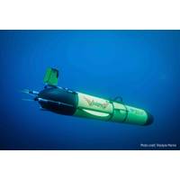
Underwater Autonomous Glider Departs to Circumnavigate the Globe
knots as it efficiently propels its way forward, enabling it to travel vast distances, staying deployed for longer.At 2.57m long and 0.33m in diameter, Redwing carries a payload of up to 3.5kg, including:CTD sensor (conductivity, temperature, depth/density)Altimeter to avoid the seafloorAttitude and compass sensors for navigationAnd a fish monitor from Dalhousie University, tracking tagged marine life such as sharks and whalesTeledyne Marine engineers will work closely with more than 50 Rutgers University students at the Center for Ocean Observing Leadership (COOL), who have helped program the navigation
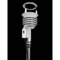
R.M. Young Company’s All-in-One Weather Station Available to Ship
, the ResponseONE-PRO offers an innovative solution for gathering essential weather data with minimal hassle and maximum efficiency. The ResponseONE-PRO measures wind speed and direction, temperature, humidity, and pressure, all from a single compact device. Optional add-ons, such as an integrated compass or precipitation gauge, allow for even greater functionality. All sensor data is transmitted as a unified output string, making integration into existing systems seamless and efficient. The ResponseONE-PRO has a user-focused design. A newly added access port allows for quick removal and replacement
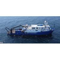
TDI-Brooks Adds to Africa Project List with Nigerian Survey
TDI-Brooks recently secured a contract with Compass Survey Limited to conduct a series of 2D Ultra High-Resolution (2DUHR) seismic site surveys and pipeline route assessments for SPDC offshore Nigeria.These projects involve the acquisition of conventional geophysical data and high-resolution seismic imaging to assess potential hazards, ensuring safe well site clearances and optimal pipeline route planning.TDI-Brooks deployed its survey vessel, R/V Proteus, to Nigerian waters for the project. The primary objective of the project was to identify potential drilling hazards and risks along the proposed

Quantum Sensor to Boost GPS-Free Navigation
the size and cost of this technology.For the first time, the researchers have used silicon photonic microchip components to perform a quantum sensing technique called atom interferometry, an ultra-precise way of measuring acceleration. It is the latest milestone toward developing a kind of quantum compass for navigation when GPS signals are unavailable.The team published its findings and introduced a new high-performance silicon photonic modulator — a device that controls light on a microchip — as the cover story in the journal Science Advances.Accurate navigation becomes a challenge
Kongsberg Discovery Launches Seapath 385 Navigation System
surveying.Seapath 385 combines inertial technology and processing algorithms with multi-frequency GPS, GLONASS, Galileo, Beidou, QZSS and geostationary satellite signals. The system integrates raw inertial sensor data either from Kongsberg Discovery’s high performance MGC® (Motion Gyro Compass) or MRU (Motion Reference Unit), together with GNSS data, and RTK, PPP or DGNSS corrections.The result is an integrated, robust and highly accurate solution that, says Vidar Bjørkedal, VP Sales at Kongsberg Discovery, delivers unique performance, every time.“Since 1994, Seapath has
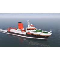
Kongsberg Sensors and Equipment for Germany's New Ocean Research Vessel
task that will require instruments and equipment with extremely precise calibration.”Kongsberg Discovery will supply Meteor IV with the EM 124 and EM 712 multibeam echo sounders, used for seabed mapping at various depths. Kongsberg Discovery will also provide the Seapath 380 with Motion Gyro Compass (MGC) R3, whose sensors use GNSS signals and inertial measurements. These combine with the EM series of echo sounders to create an exact picture of the seabed.To monitor ecosystems and marine life, Meteor IV will use Kongsberg Discovery’s EK80, a high-precision scientific echo sounder with

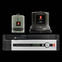
Elcome, Miros Ink Distribution Deal
response and surveillance operations,” said said Elcome International Managing Director Jimmy Grewal.. The Miros OSD system has a unique ability to evaluate multiple indicators concurrently, only triggering alarms when the “right” combination is identified. These indicators encompass wave height and behaviour, surface characteristics, and drift, which are gathered and assessed using one or more marine X-band radars, AIS receiver, wind sensor, gyro compass, as well as infrared and daylight cameras. Following data processing, Miros OSD transmits the appropriate signal to