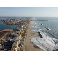
Lineup Ocean’s SURFREEF Project in Palavas-les-Flots
distance between the drone and the pilot.Throughout the operation, the drone pilot, LiDAR operator, and members of the Lineup Ocean and YellowScan teams ensured the smooth execution of the flights. Pedestrians, athletes, and residents were informed about the SURFREEF project and the ongoing mission.Data Processing The point clouds generated by the Navigator were processed and classified, then cross-checked with control points (GCP) and, for the terrestrial part, with photogrammetry data. Given the nature of the project and the mapped area, half a day was allocated for data processing.The topo-bathymetric
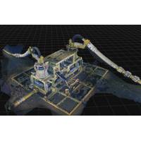
DeepOcean, Woodside Wrap Up Dual-Scope Subsea Survey at Sangomar Field
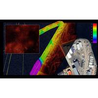
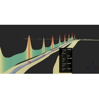
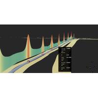
of data collected.The work used remotely operated vehicles equipped with scanning systems and software to generate digital 3D models of subsea assets using photogrammetry techniques.The complete package consisted of inspection engineers, ROV pilots, ROVs equipped with specialized scanning equipment, data processing software that enables use of computer-aided drawings (CAD), ROV footage and sonar, digital twin, and proprietary subsea 3D Imaging software that converts the data to real 3D Models.Operated by Woodside, Sangomar deepwater oil field is located about 100 km south of Dakar. It started production
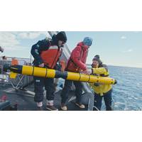
Researchers Improving Collaboration Between Divers and AUVs
team procured mostly COTS sensors and built a sensor payload that would easily integrate into an AUV routinely employed by the U.S. Navy, with the goal of facilitating technology transition. Beyond sonar and optical sensors, the payload features an acoustic modem for ranging to the diver and several data processing and compute boards.Miller's team has tested the sensor-equipped AUV and algorithms around coastal New England — including in the open ocean near Portsmouth, New Hampshire, with the University of New Hampshire's (UNH) Gulf Surveyor and Gulf Challenger coastal research vessels as
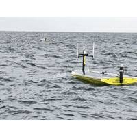
A Breath of Fresh Air: USVs Map Hypoxia in the Gulf
a vehicle out at sea, which in itself is a precarious stance."Tracking the paths of USVs. Credit: USM/SeaTrac SystemsSeaTrac SP-48 in the Gulf. Credit: USM/SeaTrac SystemsLooking forward, the team hopes for another summer of data collection, aiming to add a third SP-48 to the lineup. On the data processing side, the researchers continue to develop automation to include additional quality control steps and are looking to add a 3D model of dissolved oxygen for the entire survey area.A phase three would further the work of phases one and two, collecting critical hypoxia data and highlighting the
Kongsberg Discovery Launches HISAS2020 Synthetic Aperture Sonar
integrated payloads on Kongsberg Discovery’s HUGIN AUV family, HISAS can now be implemented across any platform – including all relevant AUVs, USVs, ROVs and towed assets – delivering clear, centimeter-level resolution, robust system design for long-term reliability, and real-time data processing. The solution, suitable for an array of defence, energy and ocean science applications, will be officially showcased at Oceanology International in London in March.Speed and precisionHISAS2020 operates in the 120–210 kHz frequency range, delivering ultra-high-resolution imagery, alongside
Kongsberg Discovery Upgrades Argeo Listen Electromagnetic Sensor
Kongsberg Discovery has upgraded its Listen electromagnetic sensor system. Formerly known as Argeo Listen, the system has undergone hardware and software enhancements, delivering improved data processing and visualisation capabilities. The platform agnostic technology is now available for a range of applications across the ocean science, defence, energy and minerals sectors, amongst others.Users familiar with Argeo Listen will recognize the enhanced software environment, now integrated with Kongsberg’s Blue Insight ecosystem. The upgraded suite enables streamlined, end to end workflows
Kongsberg Discovery Upgrades Kongsberg Listen Electromagnetic Sensor
Kongsberg Discovery has upgraded its Kongsberg Listen electromagnetic sensor system, enhancing data processing and visualization capabilities for inspections, surveys and knowledge acquisition in complex underwater environments.The system, formerly known as Argeo Listen, has undergone hardware and software improvements following Kongsberg Discovery’s acquisition of Argeo’s electromagnetic sensing technologies and recruitment of its staff in August 2025. The company said it has focused on integrating the technology into its existing portfolio while accelerating innovation.The upgraded
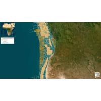
TGS Embarks on Multi-Client 2D Survey off Angola
2D survey offshore Angola.The survey covers approximately 12,600 line kilometers, with Ramform Victory having already started operations earlier in 2026.Data acquisition is estimated to be completed in approximately 100 days, with fast-track products available in the third quarter of 2026. Full data processing is scheduled for completion in the second quarter of 2027.The Ultra Profundo multi-client 2D survey marks the first 2D multi-client acquisition over Angola’s ultra deepwater areas since 2015 and targets a highly underexplored region.The survey delivers modern, long-offset seismic data
SAMS Hosts Training Course for the Era of Environmental Robotics
“Those who are familiar with such systems and understand their strengths and limitations will be ideally placed to not just adapt to this change, but help to develop and influence how robotics is used. Our course gives participants practical experience with autonomous systems and the necessary data processing skills to support that.”The new offering follows on from a development course run by the Scientific Robotics Academy last September.The new courses are backed by Argyll and Bute Council, with renewable energy developer Nadara part-sponsoring places on the courses for the first 10 applicants


