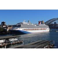
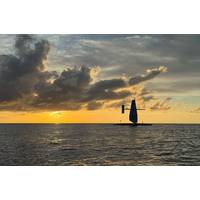
Australia Begins First Live S‑100 Bridge Trial
. It enables multiple interoperable data layers — such as charts, tides, currents and water levels — to be displayed together on a ship’s bridge, supporting more informed navigational decision‑making than traditional static charts.The trial is being led by the Australian Hydrographic Office (AHO) in collaboration with Carnival Cruise Lines, ocean data specialist Tidetech and OSI Maritime Systems (ECDIS software provider).Two Carnival cruise ships calling regularly at Sydney are participating in the trial, which places live S‑100‑based data products directly onto the bridge during
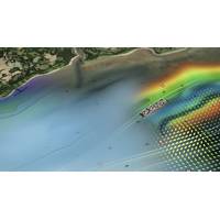
UK Centre for Seabed Mapping Scientists Collaborate on Survey of the UK’s South-West Coastline
their skills and capabilities in a single survey, the team aim to secure data to deliver the UK government’s commitments and make advances in how our seabed is mapped, understood and managed.Eleven UK CSM member organizations are involved: the Maritime and Coastguard Agency (MCA); the UK Hydrographic Office (UKHO); British Geological Survey (BGS); Centre for Environment, Fisheries and Aquaculture Science (Cefas); Department for Environment, Food & Rural Affairs (Defra), The Crown Estate; Historic England; Joint Nature Conservation Committee (JNCC); Agri-Food and Biosciences Institute, Northern
LEO Satellite Networks: Supporting Maritime Safety, Efficiency and Innovation
S-57 data format. These additional features can help to better protect navigational charts from cyberattacks designed to manipulate or corrupt maritime information, further supporting improved navigational safety.S-100 in FocusS-100 is the new data framework being developed by the International Hydrographic Organization to underpin the next generation of navigational technologies. The framework consists of a range of interoperable data layers that will overlay an S-101 ENC base layer, developed to enhance and replace the S-57 ENC format used today. By bringing together multiple, richer data sources
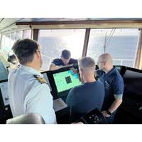
UKHO Partners with Shom to Launch International S-100 Sea Trials Program
The UK Hydrographic Office (UKHO) has launched an international sea trials program in partnership with the French Hydrographic and Oceanographic Service (Shom). The joint program represents the most comprehensive test of S-100 data standards to date and will form part of the International Hydrographic Organization’s (IHO) coordinated test bed framework. Throughout the trials, the UKHO and Shom will collect evidence to inform safety and efficiency use cases, while providing guidance on the introduction of the S-100 data framework, which is set to underpin the future of maritime navigation.
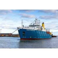
Saildrone Maps Cayman Islands EEZ
also refined cloud-based data processing workflows, enabling preliminary products to be reviewed during the mission rather than months later. Combined with persistent satellite connectivity, this approach shortened the feedback loop, improved QC, and ensured that the Cayman Government and the UK Hydrographic Office (UKHO) would receive high-confidence data sets for charting and long-term marine planning.For many islands with developing economies, the barrier to comprehensive ocean mapping is not only cost, but also logistics, including vessel charter fees, fuel, crew, mobilization, demobilization, and
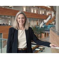
At the Helm of the UKHO
This May, the UK Hydrographic Office (UKHO) appointed Vanessa Blake as its chief executive, a role she had filled on an interim basis since May 2024. Blake first joined the UKHO in 2023 as chief customer officer, drawn by how the role leveraged all her experience and skills while still presenting a new challenge.Employing a marketing tack"I love the variety, the passion of the people here to share our expertise and help mariners across the globe to navigate safely," said Blake. "It’s an amazing organization, delivering a strong purpose for safe, secure and thriving oceans –
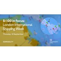
UKHO to Host ‘S-100 in focus’ Panel at London International Shipping Week 2025
The UK Hydrographic Office (UKHO) will host an in-person panel discussion during London International Shipping Week (LISW) 2025, bringing together expert voices from across the maritime industry to explore the next generation of navigation standards. Titled "S-100 in focus," the session will take place on Thursday, September 18, 2025, at Sea Containers, London, and is free to attend with advance registration. The event will examine the maritime sector’s transition to the S-100 framework, designed by the International Hydrographic Organization (IHO). Focusing on S-100&rsquo
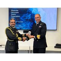
Captain Ahmed Al Badi receives 2025 Alexander Dalrymple Award
On Wednesday, August 6, 2025 the UK Hydrographic Office (UKHO) presented Captain (Aqeed) Ahmed Al Badi, Head of the Oman National Hydrographic Office (ONHO), with the Alexander Dalrymple Award for 2025. The award recognizes his services to hydrography. Captain Ahmed Al Badi was invited to the UKHO where he was presented with this year’s award. Hosted by the UK’s National Hydrographer and Director of Data Acquisition and Defence, Rear Admiral Angus Essenhigh OBE, the presentation was attended by members of the wider UKHO team, as well as by Colonel Said Al Mamari, Assistant Military
S-100 has Value Beyond ECDIS
The S-100 framework is a new global standard created by the International Hydrographic Organization (IHO), in collaboration with other hydrographic offices around the world, that enables the integration of diverse datasets within a single Electronic Chart Display and Information System (ECDIS).Mariners will be able to combine various data layers with Electronic Navigational Charts including detailed depth information and dynamic information on tides and currents.S-100 builds on the digital foundation of S-57, the standard for electronic navigational charts since 1992. The goal is to enhance situational