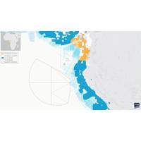
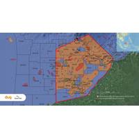
TGS to Create Major Offshore Seismic Dataset for Equatorial Guinea
a harmonized and seamless seismic data product across Equatorial Guinea's offshore basins. The full project vision includes approximately 46,343 line kilometers of 2D seismic data and more than 59,000 square kilometers of 3D seismic data.The company said the MegaSurvey would apply its latest imaging technology to address subsurface challenges and support exploration activities in the Rio del Rey and Rio Muni basins.“The Equatorial Guinea MegaSurvey is the first of its kind in the country and will apply TGS’s latest imaging technology to address key subsurface challenges and support exploration
Aker BP and Viridien Deepen North Sea Seismic Collaboration
Shelf.The agreement establishes a framework for cooperation aimed at aligning strategy and innovation efforts to improve exploration efficiency and support future discoveries offshore Norway.Under the partnership, Aker BP's operational experience will be combined with Viridien's seismic imaging technology and geoscience expertise. The companies also plan to expand multi-client OBN seismic coverage to support large-scale exploration activities on the Norwegian Continental Shelf.The collaboration will focus on advancing seismic acquisition, imaging and processing technologies to improve subsurface
Klein Marine Systems Launches MANTIS UUV Side Scan Sonar
Klein Marine Systems, a leader in advanced side scan sonar and underwater imaging technology, announced MANTIS UUV, an integrated multi-channel side scan sonar system designed to bring high-quality imaging, onboard processing, and streamlined integration to unmanned underwater vehicles.Klein's MANTIS UUV represents a new implementation of advanced side scan sonar technology for unmanned underwater vehicles, combining latest-generation components with processing for dynamic focusing, multiple-look processing, and adaptive beamforming. The result is consistent, high-resolution sonar imagery across
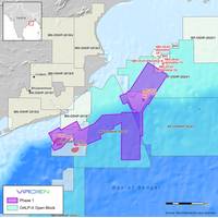
Viridien Starts Seismic Reprocessing Initiative for India’s Offshore Basins
been challenging due to low-quality imaging of legacy data.Viridien will apply the latest imaging technologies, such as time-lag full-waveform inversion (TLFWI) and least-squares PSDM (LSQPDSM), to address these challenges and produce seamless, high-quality merged 3D datasets.“The innovative imaging technology and regional expertise provided by Viridien, combined with phased project expansion throughout the Mahanadi Basin, will drive new exploration and investment opportunities for emerging plays, and support both ongoing and future bid rounds,” said Dechun Lin, Head of Earth Data at Viridien
DUG Hooks Multi-Client Seismic Reprocessing Survey off Malaysia
of the agreement, DUG and Searcher will reprocess previously acquired 3D seismic surveys within the agreed East Sarawak multi-client reprocessing area.DUG will reprocess over 60 legacy 3D surveys covering an area of up to 45,000 square kilometers from original field data using its advanced FWI imaging technology and pre-stack imaging workflows to produce one seamless 3D seismic volume of superior quality.The new, reprocessed multi-client 3D dataset will be made available for licensing to petroleum exploration and development companies enabling them to undertake more extensive evaluations of the remaining
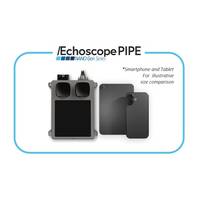
Coda Octopus Introduces Echoscope PIPE NANO Gen Series
Coda Octopus has announced the launch of the NANO Gen Series of sonars, the latest in ultra compact underwater imaging technology.The NANO Gen Series features an ultra-compact form factor, only slightly larger than a smartphone or tablet, making it ideal for integration with small underwater vehicles, diving platforms, and robotic systems.Built on the Echoscope PIPE technology, the NANO Gen Series delivers the same real-time 3D imaging performance, now extended to support advanced 4D, 5D, and 6D capabilities."With the increasing demand for smaller underwater vehicles that still require
RS Aqua, UVision Partner to Deliver Underwater 3D Imaging Technology to UK and Ireland
Ocean technology specialists RS Aqua announced their new partnership with Copenhagen based technology firm, UVision.The partnership identifies a new opportunity to bring expert underwater 3D imaging technology to the UK civil engineering industry, with affordability at the forefront. The UScanner is available to purchase starting July 30, 2025, from RS Aqua.By combining high-definition stills and positioning data, UScanner ensures efficient and reliable photorealistic 3D model generation for incredibly precise scans of harbour walls, civil engineering sites and more.The UController software enables
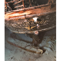
The True Color of the Endurance
Colour technology leverages machine learning to efficiently train a Colour Correction Model that can correct the distortions, producing images that represent colors as they would be perceived in air.In the podcast, St John provides insights into the Endurance project and the future of underwater imaging technology
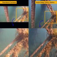
Voyis Launches Deep Vision Optics for Underwater Imaging
improves stability in photogrammetry and VSLAM processes, while higher depth of field ensures accurate photogrammetry, reducing manual intervention and accelerating data processing for faster, more reliable survey results.Deep Vision Optics represents a significant leap forward in underwater imaging technology, empowering operators with the tools needed to conduct more precise, efficient, and automated subsea inspections. Voyis remains committed to advancing the field of underwater vision, ensuring that every detail beneath the surface is captured with unparalleled clarity


