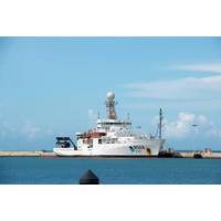
Trump Moves to More Easily Fire NOAA, DOE Employees
remain career staff, not political appointees, but would be expected to support the administration's agenda, the email to fisheries staff said.The NOAA staff who received notification that they are on the preliminary list are supervisory researchers at offices including the National Environmental Satellite, Data, and Information Service; Oceanic and Atmospheric Research; National Ocean Service; and Office of Marine and Aviation Operations, according to a source familiar with the situation.Trump attempted to reclassify thousands of federal workers at the end of his first term, an effort supported

Japan's Tenchijin to Develop, Launch Satellite by '27
Tenchijin announced the launch of “Thermo Earth of Love Project," a proprietary satellite program to enhance surface temperature monitoring capabilities. The company's satellite is scheduled for launch in 2027.Tenchijin has been using satellite data to tackle various societal challenges, including climate change mitigation, aging infrastructure, and urban planning. Tenchijin places particular importance on surface temperature data among the extensive range of satellite data.Surface temperature has been one of the key satellite data types Tenchijin has worked with since its founding.
The Power of Scientific Collaboration is Perennial
Center made a leap forward in understanding algal blooms. They were able to link an unprecedented marine algal bloom to an influx of nutrient-containing dust blown over the Indian Ocean from South Africa.Data from the European Space agency (ESA) was critical to the discovery. Multiple sets of ESA satellite data, from wide-ranging projects completed in the past, enabled the researchers to clearly track the extent of the bloom and pinpoint the dust events responsible for it.The importance of the work is that it suggests that as deserts release dust into the air and as that dust settles on the ocean'
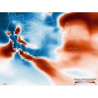
South African Drought Dust Fueled Record Ocean Bloom
, also from NOC, adds, “This is important as it suggests that as deserts release more dust into the air and that dust settles on the ocean's surface, it could help phytoplankton growth, potentially increasing the amount of CO2 the ocean absorbs from the atmosphere."The study used satellite data to study the causes of major phytoplankton blooms, focusing on the unprecedented Madagascar Bloom in late 2019 to early 2020, which was found to be the largest on record going back 24 years.It’s already known that dust from the Sahara Desert often crosses the Atlantic Ocean to the Americas
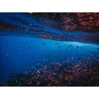
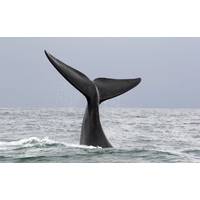
Deep Ocean Heatwaves Associated with Eddies
, such as impacts to coral reefs and species displacement. These events are becoming more frequent due to global warming, with notable occurrences off Australia’s East Coast and Tasmania, as well as the northeast Pacific coast and North Atlantic. Traditionally, they have been tracked via satellite data focusing on surface temperatures. This new research indicates that deep-water heatwaves may be significantly underreported.The research also highlights the influence of ocean currents, in particular eddies, on marine heatwaves, indicating they are a key driver of subsurface events.In the East
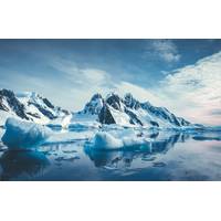
Has Antarctica Reached Point of No Return?
, but first-hand accounts from researchers about heavy rainfall, intense heat waves and sudden Foehn (strong dry winds) events at research stations that led to mass melting, giant glacier break-offs and dangerous weather conditions with global implications.With detailed weather station and satellite data dating back only about 40 years, scientists wondered whether these events meant Antarctica had reached a tipping point, or a point of accelerated and irreversible sea ice loss from the West Antarctic ice sheet."There's uncertainty about whether the current observations indicate a temporary
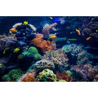
Hottest Oceans in 400 Years Threaten Great Barrier Reef
1,500 miles (2,400 km) off the coast of the northern state of Queensland.A group of scientists at universities across Australia drilled cores into the coral and, much like counting the rings on a tree, analysed the samples to measure summer ocean temperatures going back to 1618.Combined with ship and satellite data going back around a hundred years, the results show ocean temperatures that were stable for hundreds of years begin to rise from 1900 onwards as a result of human influence, the research concluded.From 1960 to 2024, the study's authors observed an average annual warming for January to March
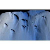
Scientists Discover Mysterious Patterns on Ice Shelf Bottom
under the ice shelf. An advanced multibeam sonar was used to map the base of the ice at a distance of about 50 meters. (Illustration: Anna Wåhlin/Science Advances)Lead author Anna Wåhlin, Professor of Oceanography at the University of Gothenburg, said, “We have previously used satellite data and ice cores to observe how ice shelves change over time. By navigating the submersible into the cavity, we were able to get high resolution maps of the ice underside. It’s a bit like seeing the back of the moon for the first time.”Karen Alley, a glaciologist from the University
Breathing New Life Into Fight to Save the Seas with Artificial Intelligence
doing. Overlaid is a database of regulations and licenses. “The machine learning (system) essentially watches the vessels doing their fishing, works out where their fishing starts and stops and whether they should have been fishing in that location.” That information might be augmented by satellite data from NASA or the European Space Agency.If anything looks amiss, for example a suspected transhipment of people or catch, it gets flagged up to one of OceanMind’s analysts, who can decide what to do next. That usually involves alerting a regulator, who can trigger a deeper investigation


