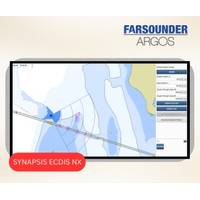
FarSounder Argos 3D Sonar Integrated with Anschütz SYNAPSIS (W)ECDIS NX
FarSounder, an innovator in 3D forward looking navigation sonar technology, has announced a new integration with Anschütz GmbH’s (W)ECDIS NX navigation platforms. This collaboration brings FarSounder’s real-time underwater detection and seafloor mapping data directly into the SYNAPSIS interface. Anschütz’s SYNAPSIS interface enables third-party systems to contribute geo-referenced data layers, such as sonar returns, onto the chart display without requiring modification to the system itself. As a result, users of FarSounder’s Argos sonar can now view in-water
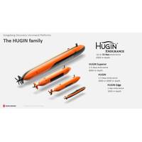
Kongsberg Discovery Starts AUV Production in the US
at our existing facility in Lynnwood, Washington. The future production facility is yet to be decided,” he added.Today, there are 12 navies using HUGIN in real-world missions such as Intelligence Preparation of the Operational Environment, Mine Counter Measure, Subsea and Seabed Warfare, and seafloor mapping operations
Subsea Europe Services, FLANQ Appointed as a Distributor of Voxometer Survey System Across Mainland Europe
end of summer 2025. Its introduction to the European market is expected to improve hydrographic surveying by reducing operational complexities and delivering superior data quality.The Voxometer is a unique marine survey system that introduces a new standard for speed, simplicity, and precision in seafloor mapping and data acquisition. As the first smart, agile, and fully automated MA3 Multi Aspect Survey System, it enables faster hydrographic surveys with significantly reduced operational complexity and cost. Designed for ease of use, even by operators with limited experience, the Voxometer delivers
CSIRO Science Ship Takes Students on Tasmanian Circumnavigation
detect that."Being at sea is where it all makes sense for marine science students."The voyage will immerse students in the full suite of marine science operations, from atmospheric and oceanographic studies to surveys of deep-sea ecosystems and marine life.Students will be involved in seafloor mapping and sediment sampling, and will also participate in the search for a historic shipwreck off the northwest coast of Tasmania.CAPSTAN students' background studies range from biological and chemical oceanography to geoscience and engineering. Women make up two thirds of students on the voyage
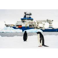
Schmidt Ocean Institute Successfully Concludes Inaugural Antarctic Expedition
also joined the expedition to ensure the vessel safely maneuvered around icebergs. The scientific operations included eight dives to depths as great as 3,918 meters (nearly 2.5 miles) using the remotely operated vehicle (ROV) SuBastian to assess biodiversity and explore vents and seafloor mapping. Ice pilots and crew transported scientists via small boats to places like Joinville Island, off the northeastern tip of the Antarctic Peninsula, for research on marine mammals and sea birds.The ship’s satellite systems also live-streamed ROV dives, connecting the global population with
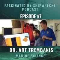
PODCAST - Underwater Robotics: Giving Marine Scientists Superpowers
the Coastal Sediments, Hydrodynamics and Engineering Laboratory (CSHEL) in the College of Earth, Ocean, and Environment at the University of Delaware. The work of CSHEL involves the development and utilization of advanced oceanographic instrumentation, particularly autonomous underwater vehicles for seafloor mapping and benthic habitat characterization. He received a bachelor’s degree in geology from Duke University in 1998, a Fulbright Fellowship at the University of Sydney in 1999, and a Ph.D. in marine sciences from the Virginia Institute of Marine Sciences in 2004. His research interests include
Canadian Shipwreck Hunters Unleash New Tech
Unlocking new levels of multibeam performance with Norwegian Subsea MRUMotion Reference Units (MRUs) are crucial in bathymetric survey technology, providing precise motion compensation data to ensure reliable and accurate seafloor mapping. For users like Captain Sid Hynes, a seasoned mariner exploring Newfoundland’s shipwreck-rich waters, the Norwegian Subsea MRU has redefined what is possible, delivering exceptional performance even in incredibly challenging conditions.The ChallengeAlong with his son, Matthew, Sid Hynes has dedicated countless hours to mapping shipwrecks using multibeam echosound
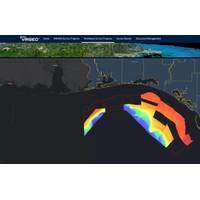
Fugro Expands Seafloor Mapping Scope for Florida’s Coastal Resilience Project
Fugro has expanded its role in the Florida Seafloor Mapping Initiative (FSMI), a multiyear effort by the Florida Department of Environmental Protection (DEP) to map the state’s seafloor for improved coastal resilience, infrastructure planning and environmental protection.Building on its previous award of 14,000 square kilometers of airborne lidar data for the FSMI, Fugro is now conducting vessel-based surveys across 42,000 square kilometers offshore Florida.This new data acquisition campaign covers five of the six Florida DEP program regions, including the entire Atlantic Coast, the Florida Keys
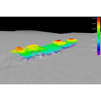
Wreck of MV Noongah Identified
members of the public also contributed to the project, including by pinpointing and reporting the location of the suspected shipwreck off the NSW coast.CSIRO research vessel Investigator completed an investigation of the unidentified shipwreck in June 2024, collecting high resolution bathymetry (seafloor mapping data) and video footage of the wreck.CSIRO Voyage Manager, Margot Hind, said the investigation showed the wreck is sitting upright on the seafloor and is largely intact.The bathymetry data shows the wreck is sitting at a depth of 170 meters and is approximately 71 meters long, with the vessel