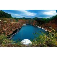
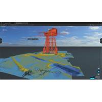
Teledyne Marine autonomously surveys DEEP's quarry lake in Wye Valley
operations to map the quarry, while the SWiFT profiler complemented the system by providing critical environmental data, such as temperature, sound velocity, and depth, to correct multibeam readings. An onboard winch enabled remote deployment, and near real-time profiler data was accessible via smartphone for immediate quality control.The electric Otter Pro vessel, launched via crane, operated both locally and remotely. During surveyor breaks, operators in Norway controlled the vessel through satellite communications, leveraging its onboard cameras and collision avoidance radar to navigate autonomousl
Teledyne Marine Announces 2024 Photo & Data Contest
Prize: HERO12 Black Creator Edition ($500 value)o Selection: The winner will be chosen from the top 10 images receiving the most votes.Category Awards:o Categories: Best Data Award, Aversity Award, Moment of Zen Award, and Underwater Award.o Prize Options: Winners can choose between a DJI OSMO Gimbal Smartphone Stabilizer, a KODAK PIXPRO WPZ2 Rugged Waterproof Digital Camera, or a Garmin Instinct 2X Solar - Tactical Edition Rugged GPS Smartwatch.o Selection: A jury will select winners from all images with more than ten votes.How to Participate:Submit your photos and data samples showcasing Teledyne
EvoLogics Debuts New Diver Navigation System
new acoustic navigation system for divers. The innovative system facilitates map-based navigation for divers on a mission, offering the flexibility of seamless two-way communication between divers and the dive supervision team, as well as pre-mission and real-time waypoint setup.Much like texting on a smartphone, the system allows a team of divers to exchange short messages with each other and the surface, while also providing real-time tracking of each other’s positions. Map waypoints can be added before or even during the mission to coordinate operations, and mark discovered objects or infrastructure
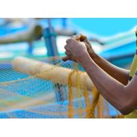
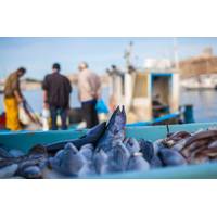
Indian Fishermen Use Smartphones to Map a Vanishing Way of Life
- to stop industry from swallowing life on the lagoon.“I am just a fisherman. I knew nothing about mapping. But I had to learn this so that our livelihoods are not destroyed tomorrow by the government,” said Bharath S. Raji, whose family has trawled Pulicat Lake in Tamil Nadu for generations.Smartphone in hand, Raji navigated the sandy lakeside banks to capture places of special interest - docks, drying areas for nets, shrines to local deities. He pointed out the holes left by the goverment’s latest coastal maps, blank spaces he said are villages brimming with life.With a new government
EIVA's Cloud-Based Thin Client Simplifies Sharing and Viewing of Project Data
in the frontend, EIVA siad.According to EIVA, users can manage and share projects with colleagues and end clients easily, simply by sending a link or by defining who can access the project. In NaviSuite Cloud Viewer, anyone you give access to can open the project in a browser on their computer, tablet or smartphone."NaviSuite Cloud Viewer is available as a yearly licence, with three plans priced according to disk usage (50, 200 and 500 GB). This release is a first step, with more extensive features to be provided in future variants of NaviSuite Cloud," EIVA said.Viewing a NaviSuite Project on
Lander Lab #4: Underwater Releases
for a predetermined time-until-release (TUR). The hours and minutes are calculated from a specific start time until the release function should begin. Carefully calculate elapsed time, and make good log entries of expected release time, programmed elapsed time, and actual start time. Smartphone pictures will help. Add 10 minutes for the burnwire corrosion, plus 1m/sec rise time for an approximate time when the lander will break the surface.The SubSeaSonics TR-45 is the only commercially available underwater timer release I am aware of. The release unit contains a microcomputer
Smartphone App Aims to Help Commercial Fishing Reduce Bycatch
A new smartphone app created in the U.K. enables the fishing industry to report accidental wildlife catch (bycatch) alongside standard catch reporting and will help to record bycatch of important marine species such as dolphins and porpoises, seals, seabirds, sharks, skates and rays.The app's developer, AST Marine Sciences Limited, part of Applied Satellite Technology Ltd, says it hopes the technology will be used by scientists and the fishing industry to help understand which wildlife species are more likely to be caught accidentally and to reduce instances of bycatch overall.According to AST
Fishermen Turn to Apps and AI to Tackle Climate Change
is at risk ... it’s a pretty dire situation,” she told the Thomson Reuters Foundation.The website has a resource library where fishermen can search for topics of interest, free online courses, a community forum, discussion groups, an events page and a blog section.Although it requires a smart phone or computer and internet connection to access—which is often patchy in coastal areas—Rife said it had low data requirements and they are looking at ways to enable users to view its information offline.The website’s resources can be easily shared via WhatsApp, Facebook or Twitter&mdash
ADCPs & DVLs: Recent Tech Developments
. Seeking to improve the efficiency of operations and decrease the cost of current measurements they recently introduced the ECO platform. ECO, Nortek’s mini-ADCP for shallow water profiling was announced for sale in late 2019. It features a handheld, wirelessly charged 1MHz ADCP, programmed with a smartphone app. Data processing and quality assurance is provided through an automatic cloud-based service. In addition to these adaptations for the instrument itself Nortek took the development one step further and designed a compact buoy and timed-release system to simplify deployment in shallow