
UAV Navigation-Grupo Oesía Releases New Version of VECTOR Autopilot Software
UAV Navigation-Grupo Oesía, a Spanish company that specializes in guidance, navigation, and control solutions for unmanned vehicles, announced the release of software version 9.2, introducing enhanced interoperability, modularity, and multi-domain operational capabilities.Version 9.2 further strengthens coordinated multi-domain UxV operations, enabling interaction between aerial and maritime platforms. The navigation and control system supports heterogeneous UAV-USV swarms, including shared situational awareness and cooperative behaviors across air and sea domains. In the maritime domain

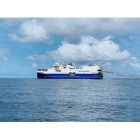
DOF Group Wins Contract Award in APAC Region
DOF Group ASA announced a large contract award for Subsea Construction and Pre Commissioning Support services in the APAC Region.Skandi Inventor will be deployed for the execution of the offshore operations scheduled to commence in Q4 2026 in North Australian waters.The scope of work includes DOF’s in-house project management and engineering, procurement and logistics support services. The duration of the offshore campaign is estimated to be between 160 and 250 days.
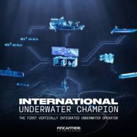
Fincantieri Strikes Four Deals in $687M Underwater Expansion
;s acquisition and integration of WASS in 2025 and Remazel in 2024. The expanded underwater platform will comprise eight companies and about 1,500 professionals across Italy, the UK, the Netherlands, Norway and the UAE.Fincantieri said the platform will combine capabilities spanning hardware, software and telecommunications, underwater platforms and services, with applications across conventional and unconventional underwater activities.The expanded capabilities are intended to serve both defense and commercial markets, including critical subsea infrastructure protection, maritime security and
Shell-Equinor JV Enlists Shearwater for 4D Streamer Survey in North Sea
Shearwater Geoservices has been awarded a 4D towed‑streamer seismic acquisition project for the Mariner field in the UK North Sea by Adura Operations, a joint venture between Shell and Equinor.The one-month survey will start in July 2026 and deploy Shearwater’s Isometrix multi‑component streamer technology to deliver repeatable time‑lapse seismic data to support reservoir monitoring and field management.The survey is designed with the potential for an undershoot, as reflected in the contractual scope, to enhance imaging and ensure continuous coverage around field infrastructure.“Shearwater
Venterra Launches Offshore Wind Data Platform for Metocean Management
Offshore wind services company Venterra Group has launched a cloud-based platform designed to provide offshore wind developers with direct access to real-time metocean measurement data, aiming to reduce inefficiencies associated with traditional data management workflows.The platform, called V-Data, was developed by Partrac, Venterra's specialist metocean and seabed consultancy, drawing on more than two decades of experience supporting offshore wind measurement campaigns.V-Data is intended to address challenges associated with handling large volumes of metocean data generated during multi-year
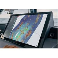
WASSP Launches BlueBeam v2 Software
WASSP, a leader in multibeam sonar technology and part of the ENL Group, announced the global release of the BlueReam v2 software for WASSP systems, an upgrade delivering advances in mapping quality, user control, water-column visualization, and operational efficiency across the entire WASSP product range.BlueBeam v2 represents the biggest leap forward in the WASSP software ecosystem in years, bringing new tools, performance improvements, and enhanced visualization capabilities to commercial fishers, superyacht operators, research vessels and hydrographic surveyors operating in more than 30 countries
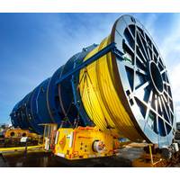
JDR Nets Subsea Umbilicals Deal for Australian Gas Project
Amplitude Energy has awarded a contract to JDR Cable Systems to supply subsea control umbilicals for its East Coast Supply Project offshore Victoria, aimed at supporting gas delivery to southeastern Australia.JDR will supply about 18 km of hydraulic control umbilicals, with options for a further 13 km depending on drilling results, the company said.The project will deliver gas to the Athena Gas Plant, which has a processing capacity of up to 150 terajoules per day, supplying homes and businesses across Victoria and South Australia.The contract includes thermoplastic electro-hydraulic production
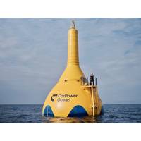
Op-Ed: Why Wave Energy Must Be the UK’s Next Great Green Frontier
The following article is an op-ed piece from CorPower Ocean, UK Marine Energy Council, Ocean Energy Europe and Professor Henry Jeffrey, Head of Policy and Innovation Group, University of Edinburgh.As an island nation with more than 11,000 miles of coastline, the UK sits beside one of the most powerful, and most overlooked renewable energy resources on Earth: ocean waves. Offshore wind has dominated Britain’s clean‑energy identity for decades, but wave power is no longer a distant prospect. It is now a proven, deployable technology whose moment has arrived. Across Europe, full-scale demonstrat
TGS Extends Multi-Year OBN Engagement in Gulf of America
Data and intelligence firm TGS has extended the ongoing multi-year proprietary Ocean Bottom Node (OBN) acquisition contract in the Gulf of America.TGS said the OBN acquisition contract has been extended for three more years.“This continuation of a long-term commitment from a major producer in the Gulf of America and strategic customer reflects our unwavering commitment to innovation and excellence and highlights our ability to adapt to evolving industry priorities.“Through our continued service quality and commitment to operating safely and sustainably, we will continue to support the


