UK Hydrographic Office Launches Digital Format for ADMIRALTY Sailing Directions
© UKHO
The UK Hydrographic Office (UKHO) has launched ADMIRALTY Digital Sailing Directions (ADSD), transforming its Sailing Directions navigational guides into an interactive digital format. Designed to simplify passage planning and increase situational awareness, ADSD moves Sailing Directions beyond static guides to a dynamic and searchable digital tool.
The launch of ADSD marks a milestone in the UKHO’s ongoing efforts to develop digital solutions that are safe, compliant and aligned with the evolving needs of mariners. It also reflects the UKHO’s wider program of work to deliver products and services that will help shape the future of navigation and support digital transformation across the maritime sector.
Trusted Sailing Directions, new features
ADSD delivers the same authoritative and compliant ADMIRALTY Sailing Directions content in a more accessible and user-friendly format, helping mariners access the information they need more quickly and easily, streamlining passage planning and facilitating more accurate decision-making on the bridge. The new features and added functionality offered by ADSD enable mariners to:
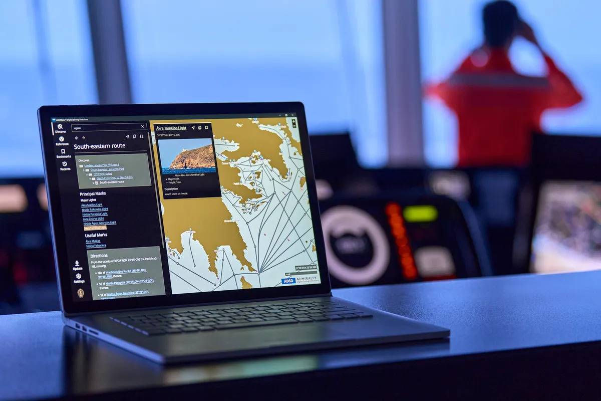
Enhance situational awareness: An integrated geo-display enables users to view navigational features and routing information in a geographical context, alongside high-quality images of coastal views and navigational aids. This bridges the gap between reading a description and visualizing the environment, improving situational awareness and navigational confidence.
Increase passage planning efficiency: With powerful search and bookmarking functions, navigators can instantly locate and save the relevant Sailing Directions for their passage planning, including port details, traffic information and navigational warnings.
Simplify route planning: The inclusion of indicative routes within the geo-display enables more dynamic passage planning, simplifying access to key routing information.
Intuitive by design ADSD has been developed in close consultation with navigating officers from around the world, including testing across a diverse range of vessel types and navigational scenarios. In a survey of more than 50 mariners who used ADSD:
- 88% of users said ADSD was intuitive and easy to use
- 91% of users agreed ADSD’s geo-display made sailing directions easier to understand
- 88% of users said ADSD saved them time in passage planning
With this launch, the UKHO will be making the 38 most popular volumes of ADMIRALTY Sailing Directions available in the ADSD format. These initial volumes cover major shipping routes including 27 of the world’s top 30 ports, with a particular focus on the primary trade corridor linking Northern Europe to East Asia. This includes continuous coverage from the UK and North Sea, through the Mediterranean and Suez Canal or via the Cape of Good Hope, across the Indian Ocean, and onward through Southeast Asia to China and Japan.
This continually expanding coverage ensures mariners navigating the world’s busiest trade routes and major ports have access to authoritative, up-to-date information across the majority of their voyage. The remaining 38 volumes will be made available by the end of 2026, providing full global coverage.