Marine Technology News Search
Search term • "advanced navigation"
Create an email alert for "advanced navigation"
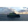
Astilleros Gondán to Build Low-emission Unmanned Surface Vessel for USV AS
USV AS has contracted Astilleros Gondán shipyard to build an unmanned surface vessel (USV), capable of significantly reducing emissions and operating expenses compared to conventional vessels utilised for subsea inspection, maintenance and repair (IMR) work.USV AS is a joint venture company established by DeepOcean, Solstad Offshore and Østensjø whose main purpose is to invest and own USVs.It is estimated…
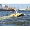
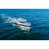
MANTAS USV Enters the SES Rental Pool
Subsea Europe Services opened the rental book on its next-gen Uncrewed Surface Vehicle (USV) for marine data acquisition to IHO s-44 standards today. The MANTAS T12 USV dubbed Autonomous Surveyor has already been put through its paces with two days of demonstrations at the German Hydrographic Society (DHyG) organised Hydrographentag 2022 conference in Bremerhaven earlier this month.Built by Florida-based USV manufacturer MARTAC Systems Inc.…
Scientists Find Micro Plastic in Arctic Ice
Tiny pieces of plastic have been found in ice cores drilled in the Arctic by a U.S.-led team of scientists, underscoring the threat the growing form of pollution poses to marine life in even the remotest waters on the planet.The researchers used a helicopter to land on ice floes and retrieve the samples during an 18-day icebreaker expedition through the Northwest Passage, the hazardous route linking…
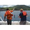
Saab Seaeye Falcon Tapped for Swedish Survey
Peab Marin chose a Saab Seaeye Falcon as a multi-functional resource in support of the company’s marine survey, salvage and civil construction operations.The Swedish marine services company says the Falcon will secure a safer working environment for its divers and will be an “excellent tool” for surveying.Robert Hedin at Peab describes the important role the Falcon will play in diver safety. “Some work can offer serious risk for a commercial diver…
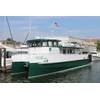
Hybrid Research Vessel Delivered to University of Vermont
Derecktor Shipyards NY in Mamaroneck, N.Y. announced it has delivered a new hybrid research catamaran to the University of Vermont (UVM). The innovative vessel, Marcelle Melosira, will serve as a floating classroom and laboratory, enabling advanced research operations and hands-on educational programs.Designed by Chartwell Marine and built in collaboration with UVM and Chartwell, the 64-foot research…
Saipem to Advance Shell's FlatFish Technology
Italian oil and gas contractor Saipem said it will work with Shell to further enhance key features of the oil major’s proprietary subsea autonomous vehicle, FlatFish.Since March 2018, Saipem has been the sole developer of FlatFish technology for Shell. FlatFish is a resident subsea autonomous vehicle able to perform complex inspection tasks, particularly suited to Brazil’s pre-salt offshore fields.
Japan, Scotland Invest in Subsea Technology
Scottish and Japanese companies will receive £9 million from a joint fund to work together on innovative subsea technology.Combined with investment made by the companies themselves, a total of £20.9 million of industrial research and development will go ahead.External Affairs Secretary Fiona Hyslop, in Japan this week to strengthen trade and investment links, announced the latest round of awards from the joint fund run by Scottish Enterprise and the Nippon Foundation.A launch in Yokohama…
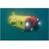
i-Tech 7 Performs UWILD for Borr Drilling
Subsea 7’s life of field business unit i-Tech 7 reports it has completed an underwater inspection in lieu of dry-docking (UWILD) project for Borr Drilling in the North Sea.Borr Drilling required a hull inspection for its Paragon MSS-1 mid-water semi-submersible, to meet ABS intermediate survey certification requirements. In place of conventional methods using divers, i-Tech 7 presented a solution using a remotely operated underwater vehicle (ROV) to reduce cost…
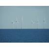
US Targets 30GW of Offshore Wind by 2030, 110GW by 2050
On Monday, March 29, the White House announced a government-wide effort to advance offshore wind, including 30 gigawatts (GW) of offshore wind by 2030, 110GW of U.S. offshore wind by 2050 and the development of a sustainable local offshore wind supply chain.“The announcement formalizes the current situation and provides more confidence to developers and the supply chain,” said World Energy Reports' Philip Lewis.
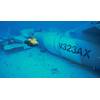
Downed Fighter Jet Recovered off Hawaii
A remotely operated underwater vehicle (ROV) was recently used to help locate a downed fighter jet off Hawaii.The privately owned Hawker Hunter aircraft crashed on December 12, 2018 while participating in the Hawaii Air National Guard sponsored training exercise Sentry Aloha. The pilot ejected before the crash and was rescued by the Coast Guard with the assistance of nearby good Samaritans, but the…
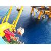
Seaspace Race Underway at Saab Subsea Docking Demo
A subsea space race is now officially underway in the offshore oil and gas industry following successful trials of docking and inspection operations using a commercially available underwater vehicle and Norwegian energy firm Equinor’s open-standard subsea docking station (SDS).The trials, witnessed by a crowd of leading players in the subsea resident remotely operated vehicle (ROV) or autonomous underwater vehicle (AUV) and hybrid space…
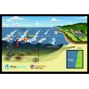
DOE Announces $25 Million for Wave Energy Research
The U.S. Department of Energy (DOE) announced $25 million in funding to support increased research, development, and demonstration of technologies that harness wave power to create electricity. Wave energy converters, which capture and convert waves into carbon-free electricity, require testing in realistic conditions to be deployed at scale.The DOE funding supports eight projects that will make up the first round of open-water testing at the PacWave South test site off the Oregon coast…
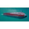
XLUUV: If You Build It, They Will Buy
In August, 2021, after years of delays, cost overruns, and rising tensions, the Australian government canceled a A$90 billion order with France’s Naval Group for 12 conventionally powered submarines intended to replace the Royal Australian Navy (RAN)’s aging fleet of six Collins-class attack subs. Overnight, the future of the RAN’s undersea warfare capability was cast into uncertainty. The very next month…
LOC Offering 3D Digital Inspections
LOC announced, as part of its digital services, the launch of a new technology offering enabling remote advanced surveying by use of aerial drones and remotely operated underwater vehicles (ROV), which will be applied to a range of assets both onshore and offshore.Survey data results are collated and reproduced in 3D imagery, by using high resolution visual, thermal, LIDAR and SONAR imaging, to create a virtual walkthrough of vessels and both offshore and onshore structures.
NOAA, Vulcan to Explore and Map the Deep Ocean
NOAA has forged a formal agreement with Vulcan Inc. to share data resulting from the two organization’s ocean work.Both NOAA and Vulcan share a mission to advance the public’s understanding of the value and importance of the global ocean. Through a new memorandum of understanding, NOAA and Vulcan intend to deepen their current work together through additional collaborative opportunities.“The future of ocean science and exploration is partnerships…

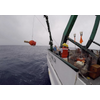
BOSS' Ocean Bottom Seismic Robotic Vehicle Prototype Passes Sea Trials
Blue Ocean Seismic Services (BOSS), the company developing autonomous subsea vehicles for seismic survey applications, said Tuesday it had completed sea trials navigating a test prototype version of its underwater vehicle autonomously underwater using BOSS’ electronics and software system during a series of sea trials completed in Perth, Australia. BOSS said that its long endurance self-repositioning…
Huntington Ingalls Industries Debuts Proteus USV
Huntington Ingalls Industries (NYSE: HII) debuted the 27-foot Proteus unmanned surface vessel (USV) for testing and development of autonomy capabilities. Proteus, outfitted with Sea Machines Robotics’ SM300 autonomy system, completed a successful demonstration off the coast of Panama City, Fla., on May 14.“We are thrilled to launch our Proteus USV. The vessel performed exactly as expected with the SM300 system’s proven and safe autonomous capability…
UKHO supports Montserrat with Seabed Mapping Data Survey
The UK Hydrographic Office (UKHO) has conducted a seabed mapping data survey in Montserrat to improve the safety of navigation around the island and to help with understanding, managing, and protecting its marine life.For this project, funded by the UK’s Conflict, Security and Stability Fund (CSSF), the UKHO worked alongside the Montserrat Hydrographic Survey Team to collect data from the waters around the island.

The Troubled History of Protecting Marine Assets
The history of protecting marine assets is a tale of endless perseverance. From the moment humans have put infrastructure in the water, it has been damaged by other humans. Despite incredible advances in technology and installations, incidents still occur at an unacceptable rate. The types and volume of marine assets have exploded since the 1850s when the first submarine telegraph cables were laid.
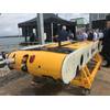
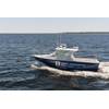
New Survey Boat Launched for South African Navy
Paramount Maritime, a Paramount Group company, said it has launched the first of three next-generation Survey Motor Boats (SMBs) to the South African Navy in continued support of its programs to enhance the capabilities and infrastructure of the South African Navy Hydrographic Office (SANHO).In addition to the three Survey Motor Boats to be delivered to the South African Navy Hydrographic Office (SANHO)…


