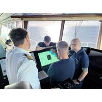
Australia Begins First Live S‑100 Bridge Trial
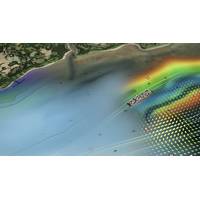
its first live shipboard trial of S‑100 digital navigation data, with dynamic tidal and current information now being tested on the bridge of operational cruise vessels in Sydney Harbour.S‑100 is the international standard for next‑generation digital marine navigation, developed by the International Hydrographic Organization. It enables multiple interoperable data layers — such as charts, tides, currents and water levels — to be displayed together on a ship’s bridge, supporting more informed navigational decision‑making than traditional static charts.The trial is being led by the Australian
Former Chief Hydrographer of MPA Awarded Prince Albert I Medal for Hydrography
Dr Parry Oei, former Chief Hydrographer of Singapore and current Senior Adviser for Hydrography at the Maritime and Port Authority of Singapore (MPA), has been awarded the Prince Albert I Medal for Hydrography by the International Hydrographic Organization (IHO).The award is one of the highest recognitions in hydrography. It is presented to individuals who have made contributions to advancing global hydrography and the safety and efficiency of maritime navigation. Conferred at the IHO Assembly, it recognizes work with lasting impact on international standards, practices and cooperation in the use of
LEO Satellite Networks: Supporting Maritime Safety, Efficiency and Innovation
S-57 data format. These additional features can help to better protect navigational charts from cyberattacks designed to manipulate or corrupt maritime information, further supporting improved navigational safety.S-100 in FocusS-100 is the new data framework being developed by the International Hydrographic Organization to underpin the next generation of navigational technologies. The framework consists of a range of interoperable data layers that will overlay an S-101 ENC base layer, developed to enhance and replace the S-57 ENC format used today. By bringing together multiple, richer data sources
UKHO Partners with Shom to Launch International S-100 Sea Trials Program
The UK Hydrographic Office (UKHO) has launched an international sea trials program in partnership with the French Hydrographic and Oceanographic Service (Shom). The joint program represents the most comprehensive test of S-100 data standards to date and will form part of the International Hydrographic Organization’s (IHO) coordinated test bed framework. Throughout the trials, the UKHO and Shom will collect evidence to inform safety and efficiency use cases, while providing guidance on the introduction of the S-100 data framework, which is set to underpin the future of maritime
At the Helm of the UKHO
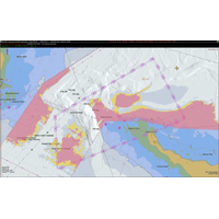
around 3,000 Defence Service Delivery customers – supporting safe navigation and enhanced situational awareness."ADMIRALTY ENC being used on board. Credit: UKHOADMIRALTY ENC. Credit: UKHOMore data, better navigationIn particular, the UKHO is engaged in the introduction of the International Hydrographic Organization’s (IHO) forthcoming S-100 framework, which will help standardize the way maritime data is collected, shared and used."Building on the foundations laid by S-57 (the standard for today’s ENCs), S-100 will bring together interoperable data layers including high-resolution
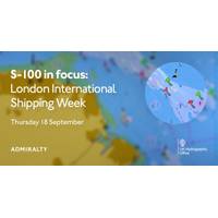
UKHO to Host ‘S-100 in focus’ Panel at London International Shipping Week 2025
. Titled "S-100 in focus," the session will take place on Thursday, September 18, 2025, at Sea Containers, London, and is free to attend with advance registration. The event will examine the maritime sector’s transition to the S-100 framework, designed by the International Hydrographic Organization (IHO). Focusing on S-100’s development and implementation, the session will cover how the new standard differs from the existing S-57 format and what this could mean for navigation, decision-making, and operational efficiency. The panel of speakers will feature a range
Phase 1 of S-100 Implementation Complete
Phase 1 of S-100 Standards implementation is now complete after the operational release of standards S-124 Navigational Warnings and S-128 Catalogue of Nautical Products.The S-100 framework is a new global standard created by the International Hydrographic Organization (IHO), in collaboration with other hydrographic offices around the world, that enables the integration of diverse datasets within a single Electronic Chart Display and Information System (ECDIS) or other hydrographic application platforms.Users will be able to combine various data layers with electronic navigational charts including
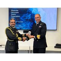
Captain Ahmed Al Badi receives 2025 Alexander Dalrymple Award
was elected as the RSAHC’s first S-100 coordinator. Instrumental in prioritizing collaboration, sharing expertise and ensuring compliance with hydrographic standards, Captain Ahmed’s contributions to the ROPME were also recognized by the UKHO. As an active member of International Hydrographic Organization’s (IHO) meetings, Captain Ahmed’s influence has led to Oman hosting multiple IHO capacity building training events. “This honor serves as a strong motivation to continue contributing to the field of hydrography with dedication and integrity. I am truly proud
S-100 has Value Beyond ECDIS
The S-100 framework is a new global standard created by the International Hydrographic Organization (IHO), in collaboration with other hydrographic offices around the world, that enables the integration of diverse datasets within a single Electronic Chart Display and Information System (ECDIS).Mariners will be able to combine various data layers with Electronic Navigational Charts including detailed depth information and dynamic information on tides and currents.S-100 builds on the digital foundation of S-57, the standard for electronic navigational charts since 1992. The goal is to enhance situational