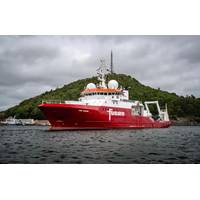
Fugro Wraps UP Seabed Mapping Work Offshore Norway
deeper ecological insights, complementing other survey activities such as metocean, geophysical, and geotechnical surveys, according to Fugro.Furthermore, Fugro collected transit data for NHS to share with the European Marine Observation and Data Network (EMODnet). This data will contribute to The Nippon Foundation-GEBCO Seabed 2030 Project, which aims to map the world's entire ocean floor by 2030."The last few years, the MAREANO program has placed emphasis on the North Sea. There is a need for marine knowledge in areas considered as particularly valuable and vulnerable. This marine knowledge
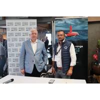
Exail Set to Bolster Ocean Floor Mapping Efforts of Seabed 2030 Project
Robotics, navigation and subsea imagery solutions provider Exail has signed a memorandum of understanding (MoU) with the Nippon Foundation-GEBCO Seabed 2030 project to advance efforts towards complete mapping of the world's ocean floor by 2030.The Seabed 2030 Project is a collaborative initiative between the Nippon Foundation and the General Bathymetric Chart of the Oceans (GEBCO).The project is dedicated to facilitating the full mapping of the global ocean floor and compiling all bathymetric data into the freely accessible GEBCO Ocean Map.This initiative is a vital part of understanding the
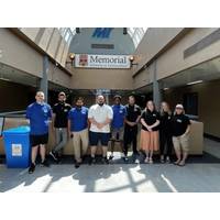
Students Spend Summer Mapping Seafloor for Seabed 2030
four areas of interest worldwide, all within eight weeks. The participants were either recent graduates or current students in the Marine Institute Ocean Mapping program of Memorial University, Canada. The mobilization was a collaborative effort among TCarta, Memorial University and The Nippon Foundation-GEBCO Seabed 2030 Project, which aims to inspire the complete mapping of the seafloor by 2030.The bathymetry was generated for the coastlines of Somalia, the Mosquito Coast, the Galapagos and the islands of the Lesser Antilles.During the summer, the students were introduced to a range of satellite
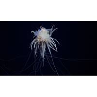
“Flying Spaghetti Monsters” Photographed at Newly Discovered Seamount
this expedition.Prior to Schmidt Ocean Institute’s expeditions this year, 1,019 species were known to live in this portion of the Pacific Ocean. The number now exceeds 1,300 and is growing. The records will be sent to the Ocean Census, an international, collaborative alliance led by the Nippon Foundation and Nekton to accelerate the discovery and protection of ocean life
New Crowdsourced Bathymetry Data Explorer Platform Debuts
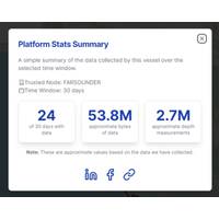
their contributions to the overall FarSounder fleet’s contributions and view the entire International Hydrographic Organization’s (IHO) CSB database on top of a global map.CSB Data Explorer was created in partnership with the International SeaKeepers Society, the IHO, and The Nippon Foundation-GEBCO Seabed 2030 Project
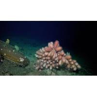
Abundant Life Found on Seamounts Off Chile’s Coast
can take many years, and Dr. Sellanas and his team have an incredible number of samples from this amazingly beautiful and little-known biodiversity hotspot,” said Schmidt Ocean Institute Executive Director Dr. Jyotika Virmani. “Schmidt Ocean Institute is a partner with the Nippon Foundation - Nekton Ocean Census Program, which has set a target of finding 100,000 new marine species in the next 10 years and, once identified, these new species will be a part of that.&rdquo
TCarta Plans Bathymetric Mapping Workshop for Jamaica
TCarta Marine, a global provider of hydrospatial products and services, will conduct a week-long coastal bathymetric mapping workshop for hydrographic surveyors in Jamaica. The workshop will be hosted by the Jamaica National Land Agency (NLA) and funded by The Nippon Foundation-GEBCO Seabed 2030 project.Scheduled for the week of February 5, 2024, at the NLA Surveys & Mapping Division headquarters in Kingston, Jamaica, the workshop will instruct participants in the use of satellite-derived bathymetry (SDB) technology with the TCarta Trident Geoprocessing Toolbox. The software-as-a-service SDB
Massive Seamount Discovered in Waters Off Guatemala
of the Seabed 2030 Project. “We are hugely grateful to all at SOI for sharing essential information that will move us further towards our goal of delivering 100% seafloor mapping by the end of the Decade.”Schmidt Ocean Institute is a partner in the Seabed 2030 initiative led by the Nippon Foundation and the General Bathymetric Chart of the Ocean (GEBCO). Seabed 2030 and partners are accelerating ocean mapping efforts and working towards the ambitious goal of mapping the entire seafloor by 2030. The absence of detailed underwater topography, or bathymetric data, hinders the ability to safely
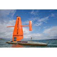
Saildrone, Seabed 2030 in Ocean Mapping Partnership
innovation to more quickly and efficiently collect ocean mapping data and support solutions for ocean mapping and bathymetric data management.The partnership was formalized today in a signing ceremony during Ocean Business in Southampton, UK.Seabed 2030 is a collaborative project between The Nippon Foundation and GEBCO (The General Bathymetric Chart of the Oceans) to inspire the complete mapping of the world's oceans by 2030 and to compile all bathymetric data into the freely available GEBCO Ocean Map. GEBCO is a joint program of the International Hydrographic Organization (IHO) and the Intergovernme


