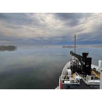
NOAA Ship Thomas Jefferson Returns to the Great Lakes to Map the Region
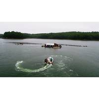
Sanctuary to identify critical habitats located within the area.Western Lake Erie, one of the shallowest areas within the Great Lakes marine transportation system, is highly trafficked by commercial and recreational vessels and has not been surveyed since the 1940s. NOAA’s nautical navigation products and services from seafloor mapping surveys are critical for a safe, and secure ocean economy. These tools reduce collisions, identify dangers to navigation, and facilitate more efficient and successful fishing operations.NOAA’s Great Lakes survey season plans for 2026. © NOAAThe Great
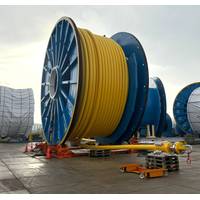
Baker Hughes, Strohm Partner On UltraDeepwater Flowlines and Risers
to be around 50% lighter than conventional flexible pipe systems, reducing suspended weight by around 40% in ultradeepwater applications and broadening the range of vessels that can be used for installation.“At Strohm, we approach product development from an end-user perspective, focusing on products that address our clients’ needs. We developed the HFP with an emphasis on installability, in-place flexibility, and design predictability, building on our long-standing relationship with Baker Hughes to create a solution which can be fast-tracked to market.“Strohm’s TCP is a corrosion-r
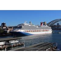
Australia Begins First Live S‑100 Bridge Trial
is being led by the Australian Hydrographic Office (AHO) in collaboration with Carnival Cruise Lines, ocean data specialist Tidetech and OSI Maritime Systems (ECDIS software provider).Two Carnival cruise ships calling regularly at Sydney are participating in the trial, which places live S‑100‑based data products directly onto the bridge during normal operations in one of Australia’s busiest and most constrained ports.The data being tested includes Tidetech’s high‑resolution S‑104 water level and S‑111 surface current datasets for Sydney Harbour. The datasets are delivered at 100m resolution
Teledyne Marine Launches New Global Video Contest
, and real innovation highlighting how Teledyne Marine technologies are used across ocean science, offshore operations, and subsea exploration.Entrants are encouraged to think outside the box and submit engaging videos that demonstrate the real-world uses of Teledyne Marine’s technology, such as:Products in action - from setup and testing to in-field operations and repairs.Subsea footage captured using Teledyne Bowtech cameras.Data captured by Teledyne Marine’s sensors such as multibeam sonars, single beam, or ADCP data integrated into the video.AUV and Glider deployments or underwater mission
Carbon Removal Project Supports Maine’s Aquaculture Market
;In trials conducted by the team, results first showed that the approach is biocompatible and doesn't kill the larvae, and later showed that the oysters treated by MIT's buffer approach did better than mineral or chemical approaches. Importantly, Hatton also notes, the process creates no waste products. Ocean water goes in, CO2 comes out. This captured CO2 can potentially be used for other applications, including to grow algae to be used as food for shellfish.Varanasi and Hatton first introduced their approach in 2023. Their most recent paper, “Thermodynamics of Electrochemical Marine Inorganic
Massa Products Corporation Showcases at Sea-Air-Space 2026
Massa Products Corporation, a leader in electroacoustic and ultrasonic technologies, will be participating at Sea-Air-Space 2026, a maritime exposition for defense industry leaders and key military decision-makers.At this year's event, Massa will be joined by five partners: Sonalysts, Forge Nano, Orr Partners, HRP Associates, and LeVanta Tech. Visitors to the Massa exhibit (booth #1347) will have the opportunity to engage with representatives from all six organizations, explore joint capabilities, and learn how these partnerships deliver value across military applications.

Bedrock Appoints Matthew Tirman as CEO
companies across geospatial intelligence, data platforms, and high-growth global commercial operations. He previously helped lead Satellogic through early commercial traction to tens of millions in revenue and its public market debut. Under his leadership, Satellogic delivered imagery and data products to defense and intelligence customers worldwide, and space system sales to include a broad area maritime constellation. As CEO, he will drive Bedrock's strategy, go-to-market execution, and operational growth. Founder Charles Chiau will continue as Chief Technology Officer, focusing on hardware
Intruder Alert: Ports Face a Range of Underwater Threats
, underwater surveillance systems provide the means to detect and track intrusions beneath the surface. The most widely deployed technology for this purpose is the intruder detection system (IDS), which uses high-frequency active sonar to detect the presence of divers, SDVs, and increasingly small UUVs. Products such as the Forcys Sentinel, AquaShield from DSIT Solutions, and Norbit’s GuardPoint offer integrated solutions that combine sonar sensors, signal processing software, command-and-control interfaces, and even underwater loudhailers.These systems are typically arranged as networks of sonar
NOAA Ship Rainier to Map Critical Mineral Deposits in Pacific US Waters
leg will use autonomous underwater vehicles from Orpheus Ocean to acquire high-resolution seabed imagery and geological samples, in partnership with the NOAA Ocean Exploration Cooperative Institute. NOAA will produce publicly accessible maps and images of these federal waters in the Pacific. These products will inform NOAA, other federal agencies and interested parties of the likelihood of finding critical mineral deposits in the surveyed area. This effort will generate high-quality, deep-ocean data to help increase the baseline understanding of the deep-ocean environment, as well as stimulate further


