
TGS Licenses Imaging Software to Shell, Secures OBN Contract in North America
Norwegian seismic company TGS has signed a global multi-year agreement with Shell to license the TGS Imaging AnyWare software suite, announcing also it has secured another contract for the Ocean Bottom Node (OBN) data acquisition work in North America.The agreement with Shell provides opportunities for strategic collaboration and underscores the company’s commitment to harnessing advanced technology to elevate data processing and analytical capabilities for its clients.Through the agreement, Shell will migrate from their current in-house software to Imaging AnyWare."We are pleased to
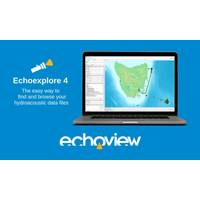
Echoexplore 4 aims to Simplify Hydroacoustic Data Management
Echoview Software releases Echoexplore 4 a tool which aims to help catalogue large numbers of hydroacoustic files effortlessly. To do this, Echoexplore identifies compatible echosounder and sonar data files on a local computer or local network, extracts metadata, and then creates a spatial catalog that allows users to browse the data that has been located. Whether searching for specific hydroacoustic data sets, sorting and browsing through lists or maps, or filtering based on parameters like geographical position, date, time, hardware model, pulse duration, transmitted power and more, Echoexplore
PGS Streamlines Seismic Data Interpretation Services
Norwegian seismic company PGS has teamed up with Onward, an energy innovation platform, to offer on-demand seismic data interpretation.The collaboration that facilitates on-demand data interpretation provided by Onward, which leverages its technical capabilities to enhance PGS' existing MultiClient and Data OnDemand services and accelerate interpretation workflows.Onward and PGS now offer subscribers of PGS' OnDemand services the option to access Onward's interpretation services and unlock the subsurface potential of extensive seismic data sets.PGS subscribers that engage Onward's
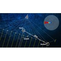
Kongsberg Discovery Unveils Sub-Bottom Profiling Tool for Proprietary Echo Sounders
Norwegian ocean science technology provider Kongsberg Discovery has introduced EM®SBP software system, which offers sub-bottom profiling capability for Kongsberg's deep-water multi beam echo sounder (MBES) systems EM 124 and EM 304, without the need for additional hardware.A sub-bottom profiling system complements MBES surveys tailored to map the seabed and sub-seafloor.Gathering sub-bottom data is necessary to understand sediment thickness and distribution, as well as for detecting buried objects or infrastructure, such as boulders or pipelines.A sub-bottom signal must have specific properties
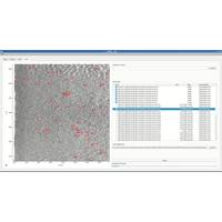
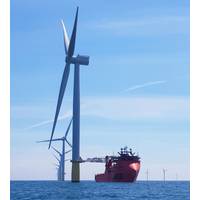
AI Tool to Tackle Boulder Issues for Offshore Wind Developments
to calculate the time and cost of boulder clearance.Ocean Geophysics’ new AI-driven boulder identification tool leverages a machine learning algorithm that allows for the automatic detection of boulders as small as 25 cm in size and automatically removes duplicates, according to the company.The software can process entire seabed survey areas quickly, taking around one second per side-scan line to detect all boulders, Ocean Geophysics claims.The company will integrate the tool with its specialist offering of processing, interpreting and reporting of marine geophysical data, noting that the software
Metis and Esvagt Team Up to Enhance SOV Data Analytics
context of a five-day forecast for weather conditions, added Theodossopoulos.Features include a new depiction of total fuel oil consumption by activity across multiple scenarios, including transit, personnel transfer, time-in-port, etc., which takes account of different weather conditions.The enhanced software functionality also introduces a heightened level of transparency to dynamic positioning (DP) operations taking into consideration that DP systems play a critical role in maintaining positions and ensuring the safe transfer of technicians to offshore installations using 'walk-to-work' gangways

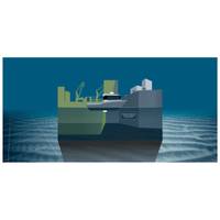
New Cloud Platform for Subsea Survey Data
to actionable insight and information with its cloud based MDP, which enables access to underwater sensor data in near real-time. Further, the platform’s automated analytics improves quality and presents results within standardized parameters, so stakeholders are not required to purchase multiple software packages.“We have taken a completely technology agnostic approach in that data from any subsea sensors can be directly transmitted to our platform, where it is safely stored in a maintained and secured data space, which also provides full management and processing capabilities. From here it
NEW PRODUCT: EIVA Debuts Entry-level Hydrographic Survey Software
EIVA’s new software variant NaviSuite Kuda Core provides advanced hydrographic survey software capabilities at an entry-level price. Tailored to support hydrographic surveys with a single USV or small survey vessel using multi-beam echosounder (including backscatter), LiDAR and/or camera, this software solution is priced at €1,998 annually, designed to be simple to configure and run.In addition, it provides advanced hydrographic survey features from NaviSuite Kuda software, for example enabling autonomous operations, as it is one of several variants of this software bundle.Not only
Greensea Inks Deal with Ocean Infinity
Greensea signed a contract with Ocean Infinity to collaborate and develop the Armada Dynamic Payloads Control software suite on OPENSEA. “Greensea is excited to collaborate with Ocean Infinity on this pioneering technology,” said Ben Kinnaman, Greensea CEO. “Their plan is the most radical shakeup to the way work has been done on and under the sea since ROVs were developed. This type of paradigm shift can only happen when barriers are removed and multiple companies can collaborate. That’s what an open architecture platform, like OPENSEA, does. It removes barriers and


