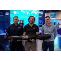
Saildrone Introduces High-Endurance Anti-Submarine and Strike USV
a wingless configuration, maximizes speed and minimizes visual and radar signature. Its lower profile is ideal for operations where speed, visibility, and signature impact mission performance. From the outset, Spectre was designed to operate without the wing for kinetic strike roles, which require higher sprint speeds and low-profile stealth operations.Technology PartnershipsSpectre performance has been verified and tested at Force Technologies’ tow tank in Copenhagen, Denmark. Many months of testing and evolution on a 1/7th-scale model verified propulsive power requirements and seakeeping in conditions
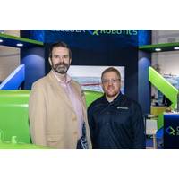
DroneQ Robotics, Mark Offshore Collaborate with R/V Mintis
, USBL, imaging sonar, Side Scan Sonar, UT and CP probes, underwater cavitation cleaning system, water sampling system and a 2-function gripper system.The Argus Rover, OCROV Class II ROV system (2025) with WCROV capabilities rated for 1000m working depth, advanced station keeping system with Sonardyne SPRINT-NAV INS + DVL, USBL, subsea 3D imaging capabilities powered by Vexis Discovery Stereo with VSLAM technology, imaging sonar, UT, CP and FMD NDT probes, onboard High Pressure and Flexiclean underwater cleaning systems, and a HydraLek 5600 manipulator skid (50 kgs lifting capacity at full reach). The
Sonardyne Navigation Selected by Njord Survey for ecoSUB AUVs
Swedish innovator Njord Survey has chosen Sonardyne navigation technology for its ecoSUB Robotics autonomous underwater vehicles (AUVs) to transform subsea survey operations. Using Sonardyne’s smallest navigator, SPRINT-Nav U, on ecoSUB’s low-logistics AUVs, Njord Survey is targeting at-scale survey operations, starting with UXO surveys. Underpinned by accurate navigation, deployment at scale will enable parallel operations, reducing vessel dependency, logistics, cost and time for these types of
Cellula Robotics Selects Sonardyne for Long-Range AUVs
Autonomous subsea robotic systems developer Cellula Robotics has chosen Sonardyne navigation and positioning technology for its long-range autonomous underwater vehicle (AUV) platforms.The company has ordered multiple Sonardyne SPRINT-Nav X navigation systems - Sonardyne's highest grade and underwater navigation system.The company has also selected Sonardyne’s AvTrak 6 for tracking, communications and mission control. Part of the package/purchase is multiple Sonardyne Ranger 2 Ultra-Short BaseLine (USBL) positioning and communications systems for both AUV end users and demonstration and
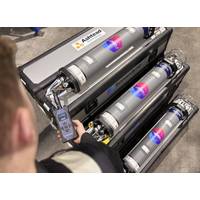
Ashtead Technology Places New Order for Sonardyne’s Fusion 2 Platform
Sonardyne has received a major new order for its Fusion 2 platform and 6+ technology from Ashtead Technology.This investment increases Ashtead Technology’s rental fleet of Sonardyne Compatt 6+ to well over 1,000 units. The units integrate Long BaseLine (LBL) and SPRINT INS into a single, streamlined platform, Fusion 2, supported by Sonardyne's 6+ hardware.Fusion 2’s advanced capabilities include full LBL support, real-time SLAM calibration for sparse arrays and wireless structure deflection monitoring.These features significantly reduce transponder count, vessel time and operational
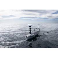
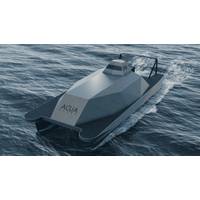
RS Aqua Announces Strategic Partnership with US -based Seasats to Bring Autonomous Surface Vehicles to UK and Ireland Defence Market
platformsBrowser-based UI operable via secure tablet, laptop, or mobile deviceLaunch/recovery in <10 minutes with man-portable components and no shipboard crane or davit requiredTechnical Specifications:Length: 11.4 feetEndurance: Multi -monthRange: 8,000 nautical milesCruise speed: 2.0 knots (5 knots sprint)Power: 415W nominal solarBattery: 4.0 kWh lithium-ionOperational sea state: Up to Sea State
Voyis, EIVA Introduce Geo-Located Camera-Based Mapping
acquisition begins. This ensures that every 3D point generated by the VSLAM solution is immediately tied to a known global reference frame.Absolute Geo-Located Mapping from the Start of a DiveVoyis VSLAM Powered by ElVA NaviSuite reads the initial global position from a connectedINS, such as a Sonardyne SPRINT-Nav, and places the map into the selected geodetic frame at mission start. This global placement is preserved throughout the dive, even after relocalization or loop closure events. While the SLAM engine continues refining local map geometry, its global alignment remains stable.This advancement transforms
UK Backs Development of 145-ft Uncrewed Offshore Support Vessel
motions in high sea states. Pioneer became the first uncrewed surface vessel to receive UK MCA Workboat Code 3 approval this year, providing key operational data for the larger MROS design.The 43-metre vessel will offer DP1 station keeping, a 2,500-nautical-mile range, endurance of more than 20 days and sprint speeds above 20 knots. It is designed for roles such as offshore logistics, surveillance, subsea inspection, intervention and offshore commissioning and decommissioning. Payload capacity will reach 80 tonnes, including space for ISO-standard containers and a moonpool configured for twin launch and
![Aerial view of the Rock Islands and coral seascape at the Republic of Palau. [Photo credit: The Nature Conservancy]](https://images.marinetechnologynews.com/images/maritime/w200h200padcanvas/aerial-view-rock-165050.jpg)
Bezos Funds AI Nature Projects
we grow food, protect wildlife, and power our planet to make a true impact.”The winning projects span five continents, from an AI-driven coral reef monitoring network in the Pacific to a weather forecasting model designed for African farmers.The awardees were chosen following a global innovation sprint supported by partners including Amazon Web Services, Google.org, Microsoft Research, Ai2, and Esri, who provided mentorship, tools, and computing resources to help move ideas from concept to impact.Plymouth Marine Laboratory (PML) was one of the 15 selected. The university’s project involves