GeoAcoustics, Ocean Floor Geophysics Tackle Single Towfish Solution for Side Scan Sonar, Magnetometer

© GeoAcoustics
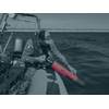
GeoAcoustics Ltd and Ocean Floor Geophysics (OFG) have joined forces to develop a combined side scan sonar and magnetometer system as a single towfish. The new configuration integrates the GeoAcoustics GeoScan side scan sonar with OFG’s Self-Compensating Magnetometer (SCM), bringing acoustic imaging and magnetic detection together in a single streamlined platform.
The collaboration builds on the high-resolution imaging capability of the simultaneous dual-frequency GeoScan system and the SCM’s unique real-time compensation to address a long-standing operational challenge in marine survey. Traditionally, magnetometers must be towed at a significant distance behind side scan sonars to avoid interference from magnetic components on the towbody. This requires the deployment of two separate towfish, either towed inline one following the other, or on separate cables. These conventional configurations of marine magnetometers increases deck handling complexity, layback management and operational risk, particularly from smaller vessels and unmanned surface vessels (USVs).
The new configuration integrates the SCM directly onto the tail of the GeoScan side scan sonar via a dedicated stinger assembly. The SCM’s self-compensation capability enables it to operate effectively in close proximity to metallic survey hardware, making true single-towfish deployment possible.
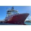
The development also reflects the growing use of USVs in hydrographic and geophysical operations. Launching multiple towed systems from a USV presents significant practical challenges and increased operational risks. A single GeoScan towfish integrating the SCM is a simpler configuration, lowering risk to remote and autonomous survey operations.
By reducing two towed bodies to one, the system simplifies launch and recovery, improves survey efficiency and enhances operational safety. The solution is particularly relevant for unexploded ordnance (UXO) surveys, where high-resolution seabed imagery and magnetic anomaly detection are routinely required together to identify and classify targets.
Beyond UXO detection, the combined system can support cable route investigations, marine construction projects, archaeological surveys and subsea infrastructure inspection, where acoustic and magnetic datasets provide complementary insight.
GeoAcoustics and Ocean Floor Geophysics are currently progressing development of the single-towfish configuration, with availability anticipated in Q3 2026.