Satellite Derived Bathymetry Aids Hydrocarbon Exploration
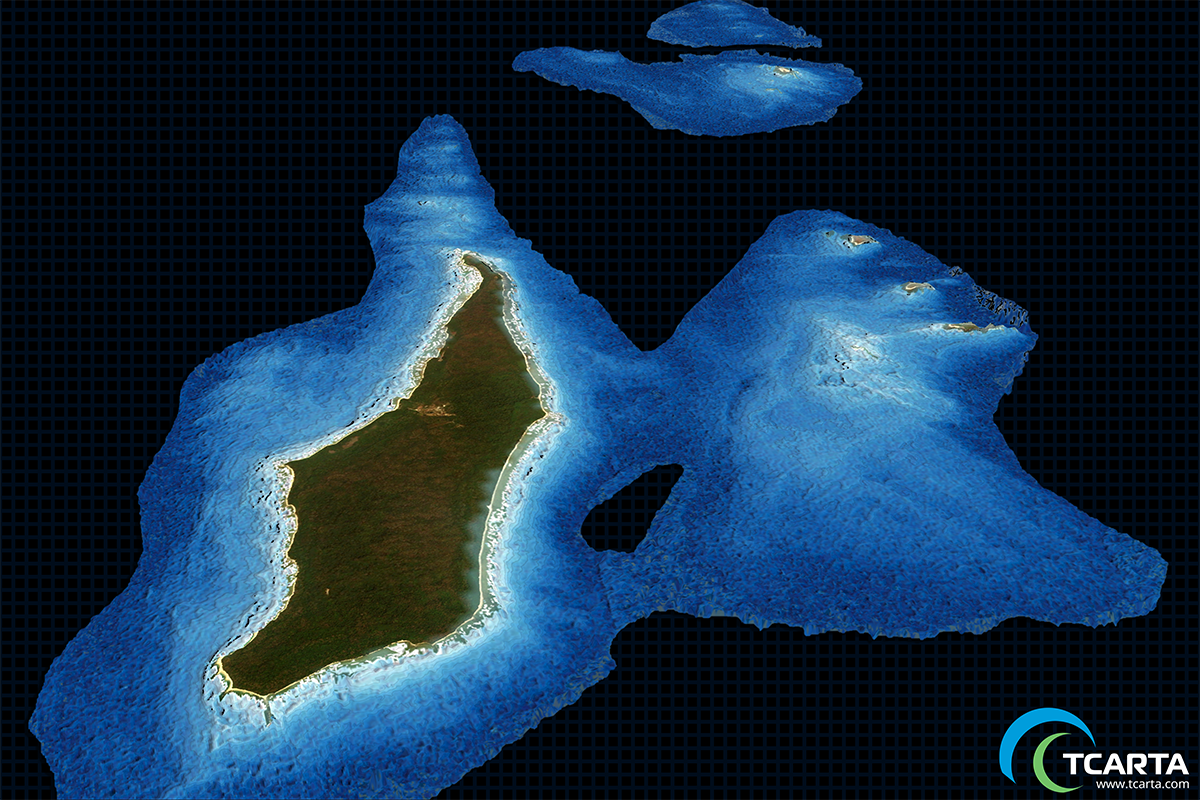
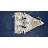
Satellite Derived Bathymetry (SDB) at a resolution of 10m (Image: TCarta)
U.K. based marine geospatial products provider TCarta said it has delivered satellite derived bathymetry (SDB) to one of the world’s largest oil and gas producers, Total SA, who will use the water depth data for preparing seismic survey works off the coast of Myanmar.
The SDB dataset, which covered a 30-square-kilometer area around Preparis Island in the Bay of Bengal, was generated by digitally extracting water depth measurements from multispectral imagery acquired by the European Space Agency’s Sentinel-2 satellite. The resulting bathymetric data had a point spacing of 10 meters with measurements to a depth of 15 meters.
This process, according to TCarta CEO David Critchley, saves time and money.
“Our processing team delivered the satellite derived bathymetry just a few weeks after Total placed the order,” Critchley said. “Traditional airborne or shipborne bathymetric mapping would have taken several months and cost 10 times more.”
Total contracted with TCarta for the Preparis Island project following a benchmark study that also generated bathymetric data from Sentinel-2 imagery.
In addition to the benefits of cost effectiveness and rapid turnaround, the remote collection of imagery by satellite poses no risk to personnel or the environment. Furthermore, the bathymetric data can be captured in all parts of the world, even where security restrictions limit operation of aircraft or ships.
TCarta said its SDB products have become increasingly popular among environmental organizations and infrastructure development firms, but especially energy exploration and production companies.
“Global energy companies are becoming one of the largest markets for TCarta SDB and other marine geospatial products,” Critchley said.
Another TCarta product used extensively in offshore hydrocarbon exploration and production is the Global GIS Bathymetry Package. This GIS-ready dataset provides a level of marine information superior to public-domain data for areas throughout the world. The 90- and 30-meter products each contain a Digital Bathymetry Model with spot-depth values, contour lines and high-resolution shorelines derived from multiple data sources. These include nautical charts, single- and multibeam survey data, LiDAR, SDB, altimetry data and seismic survey derived depths.
TCarta stressed it has made its products easy for customers to obtain. In 2017, the company launched its Bathymetrics online portal, allowing customers to search for the availability of off-the-shelf TCarta products, including SDB and 90-meter bathymetric datasets. Clients can search for data, place an order, and instantly download the purchased products.