Terradepth Achieves IHO Special Order Standard for Seabed Mapping Accuracy
© Terradepth
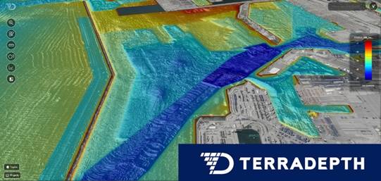
Terradepth, a seabed information company, successfully completed an IHO S-44 Special Order survey with an autonomous underwater vehicle (AUV). This achievement meets one of the most stringent international standards for hydrographic accuracy.
The survey took place in approximately 80 meters of water, 60 miles offshore in the Gulf of America, a region affected by hurricanes and subsea infrastructure development. Despite the absence of local tide stations or buoys, European Remote Sensing (ERS) satellite radar was used to correct for tidal variations, demonstrating a fully autonomous and low-logistics survey approach.
The IHO S-44 Special Order standard relates to areas where underkeel clearance is critical. Therefore, 100% feature search and 100% bathymetric coverage are required, and the size of the features to be detected by this search is more demanding than lower IHO orders.
As part of Terradepth’s delivery model, survey results were processed and delivered through Absolute Ocean, the company’s secure, cloud-native ocean data platform. This delivery enabled efficient execution and rapid access to results. It also empowers stakeholders to perform quality assurance, quality control, visualization, and decision-making from anywhere.
The achievement of the IHO Special Order standard has broad implications across various industries. AUV-enabled surveys yield crucial insight into seabed characteristics, infrastructure integrity, and cable/foundation conditions across all depths. Further, Terradepth’s data and information quality satisfies National Marine Fisheries Service permitting exemptions and most BOEM requirements.
For government agencies and offshore energy operators, the IHO Special Order certification proves the readiness of Terradepth’s AUV-collected data and processed information for operational use.