Viridien Kicks Off Seismic Imaging for Utsira North OBN Survey
(Credit: Viridien)
Viridien has started the processing and imaging phase for the Utsira North multi-client Ocean Bottom Node (OBN) seismic survey in the Norwegian North Sea, to support exploration and development on the Norwegian Continental Shelf.
The processing and imaging phase follow the completion of acquisition earlier in 2025. Final imaging results are scheduled for delivery for industry licensing in the third quarter of 2026.
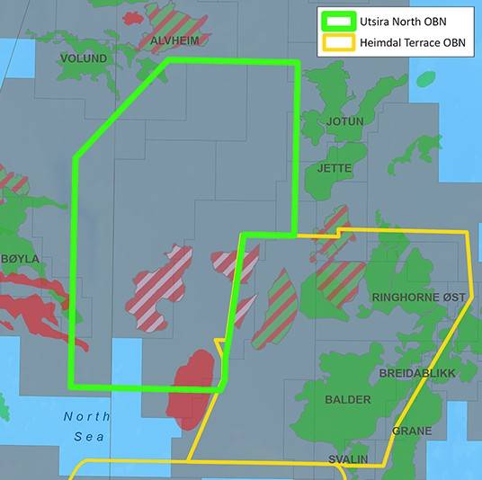
The 513 sq km Utsira North OBN survey is located to the east of the Alvheim Field in the Southern Viking Graben and will bring crucial insights into one of Norway’s most strategically important offshore areas, unlocking opportunities for near-field exploration and more efficient extraction of existing reserves in mature basins.
The survey also enriches Viridien’s expanding multi-client OBN portfolio and further consolidates its strategic position in the North Sea as a leading innovative provider of OBN imaging on the Norwegian Continental Shelf (NCS).
Viridien’s teams are currently applying their seismic imaging workflows, including the latest proprietary time-lag full-waveform inversion (TLFWI) technology, to deliver unprecedented seismic images of this region.
As a result, Utsira North OBN will enhance resolution of the region’s complex geological intervals, illuminating how deep-seated faults help dictate sediment distribution and, in turn, clarifying the presence of reservoir facies and prospective new targets, according to Viridien.
“Viridien’s imaging and licensing of the Utsira North OBN multi-client data reaffirms our long-term commitment to the NCS and our technological leadership in the region.
“Once again, as a high-value data provider, we are leveraging our unmatched subsurface imaging capabilities to deliver next-generation data that will empower E&P companies to make better decisions in mature and increasingly complex environments, maximizing returns from their existing infrastructure and near-field exploration investments,” said Dechun Lin, Head of Earth Data at Viridien.