Hydrographic Survey
Applications and Equipment
A hydrographic survey implies data collection about certain bodies of water. Its purpose is to ensure the safety operation of boats and detecting any impediment that might occur. Some use the term to refer only to ocean and sea waters, while others use it in reference to any type of water, including rivers and lakes. For a hydrographic survey, scientists gather data about waves, currents and tides, aiming to create a pattern of how that water area behaves.
While some environmental factors and characteristics of water can be predicted, such as tides, the level of temperature and salt, others are variable and do not always fall into a pattern, like wind. In the process of hydrographic survey, other factors must be included in the analysis. Specialists measure the depth of the water in rivers or oceans, taking into account the reefs and rocks undersea.
As stated, hydrographic surveys have the purpose of insuring safety travel for vessels, therefore the analysis must follow certain strict conventions and regulations. For instance, if the depth of the water varies, the specialists must note the lowest depth possible, rather than calculating its average. Because of this, many believe that these recordings are not accurate, since they do not offer a loyal representation of the waterbed. Consequently, two different types of measurements take place in a survey – those focused on safety and those that provide accurate measurements, the latter ones being called bathymetric charts.
Applications of hydrographic survey
Maps resulting from hydrographic survey are mainly used for maritime safety and navigation. Both the public and private sector make significant investments in this field to ensure the safe navigation of their vessels and to exploit the subsea and above the sea environments in an optimum manner, gaining advantages of tactical, strategic or operational nature. The data collected is used in cable routing, research, educational purposes, dredging operations and many other applications.
Navigators are especially concerned in parameters such as the shape of the shores, depth of water, and type of ocean bed, so they can estimate correctly their navigation experience. This type of survey was usually made using either echo sounding or sonar methods, but they have been replaced with more advanced technology such as satellites with sophisticated electronic sensors. However, the traditional survey methods have not been eliminated.
The governments of many countries fund hydrographic surveys however there are also private companies that manifest increasing interest in this aspect. The strategies and methods of survey must be in accordance with the ones used by the International Hydrographic Organization.
Hydrographic Survey Equipment
The first surveys were conducted by measuring depths with sounding poles and hand lead lines, determining positions with three-point sextant fixes. In the 30’s, eco sounders were first developed, and they enabled the collection of more data than before. The hydrographic survey process was also sped up by the invention of electronic navigation systems, in the next decade. Nowadays, the nature of these surveys has become more complex and requires the use of very sophisticated technologies, that accurately measure parameters such as reefs, wrecks, banks, other obstructions, water depth, coastline position with high and low water marks (HW and LW), tide rips, fishing stakes, nature of the seafloor and the position of all floating navigation marks.
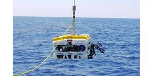
Equipment for hydrographic survey can be installed on all types of vessels, including ships, small vessels, AUVs (Autonomous underwater vehicles), UUVs (Unmanned Underwater Vehicles) or inflatable crafts. It may consist of magnetometers, sidescans, single and multibeam equipment featuring sidescan and multibeam sonars. In addition to this equipment, these surveys also use airborne remote sensing systems such as LIDAR (with laser techniques) and optronics.
For instance, in 1994, US Army Corps of Engineers (USACE) used the Scanning Hydrographic Operational Airborne Lidar Survey (SHOALS) in order to encourage the investments from private sectors in Lidar bathymetry, a technique that can accurately measure depths and topographic elevations, is able to cover extensive areas and was proved more efficient than the traditional acoustic survey methods.
The magnetometer is a tool that measures magnetic fields, in terms of strength and direction. Magnetometers are especially used in geographic surveying because they can detect large deposits of ferrous materials, but also in searching the precise location of shipwrecks and in pipelines surveys. They are more difficult to use than other instruments, yet the pieces of information they provide and more accurate and reliable.
Sidescan sonars are a type of sonar systems that are able to create images of ocean floor (or lake or river bottoms) and they are appreciated and highly popular due to their low cost. They are also known as side-imaging sonars, single-beam echo sounder, side looking sonars, or bottom classification sonars. In addition to providing seafloor samples, and information on the type of texture in the ocean floor, they can also detect debris items that may prevent navigation or the activity of oil and gas companies and asses the condition of pipelines and cables on the sea floor and also provide accurate dimensions of the items investigated. Consequently, sidescan sonars are used in several industries, such as oil and gas industry, marine research and science, education, hydrographic agencies, coastguards.
This piece of equipment features three components – a towfish, a cable for transmission and a processing unit. The towfish transmits and receives sounds from the surrounding ocean floor area and uses the echoes to create a “picture” of the seafloor, in which the protruding objects appear in dark and the shadows are lighter. Sidescan sonars are successful in offering accurate pictures of the investigated areas, but they cannot measure depths.
The multi beam eco sounders are in fact sidescan sonars mounted on an array. These devices create a "swath" of soundings in order to fully cover an area.
Portable tide gauges are other instruments used in hydrographic survey, with the purpose of measuring the sea level and tsunami detection. They can also store the results of calculations of Significant Wave Height and Full Wave Frequency.
All this equipment cannot function unless featuring proper software applications. Companies sometimes develop their own software, in order to fulfill particular tasks.
A hydrographic survey implies data collection about certain bodies of water. Its purpose is to ensure the safety operation of boats and detecting any impediment that might occur. Some use the term to refer only to ocean and sea waters, while others use it in reference to any type of water, including rivers and lakes. For a hydrographic survey, scientists gather data about waves, currents and tides, aiming to create a pattern of how that water area behaves.
While some environmental factors and characteristics of water can be predicted, such as tides, the level of temperature and salt, others are variable and do not always fall into a pattern, like wind. In the process of hydrographic survey, other factors must be included in the analysis. Specialists measure the depth of the water in rivers or oceans, taking into account the reefs and rocks undersea.
As stated, hydrographic surveys have the purpose of insuring safety travel for vessels, therefore the analysis must follow certain strict conventions and regulations. For instance, if the depth of the water varies, the specialists must note the lowest depth possible, rather than calculating its average. Because of this, many believe that these recordings are not accurate, since they do not offer a loyal representation of the waterbed. Consequently, two different types of measurements take place in a survey – those focused on safety and those that provide accurate measurements, the latter ones being called bathymetric charts.
Applications of hydrographic survey
Maps resulting from hydrographic survey are mainly used for maritime safety and navigation. Both the public and private sector make significant investments in this field to ensure the safe navigation of their vessels and to exploit the subsea and above the sea environments in an optimum manner, gaining advantages of tactical, strategic or operational nature. The data collected is used in cable routing, research, educational purposes, dredging operations and many other applications.
Navigators are especially concerned in parameters such as the shape of the shores, depth of water, and type of ocean bed, so they can estimate correctly their navigation experience. This type of survey was usually made using either echo sounding or sonar methods, but they have been replaced with more advanced technology such as satellites with sophisticated electronic sensors. However, the traditional survey methods have not been eliminated.
The governments of many countries fund hydrographic surveys however there are also private companies that manifest increasing interest in this aspect. The strategies and methods of survey must be in accordance with the ones used by the International Hydrographic Organization.
Hydrographic Survey Equipment
The first surveys were conducted by measuring depths with sounding poles and hand lead lines, determining positions with three-point sextant fixes. In the 30’s, eco sounders were first developed, and they enabled the collection of more data than before. The hydrographic survey process was also sped up by the invention of electronic navigation systems, in the next decade. Nowadays, the nature of these surveys has become more complex and requires the use of very sophisticated technologies, that accurately measure parameters such as reefs, wrecks, banks, other obstructions, water depth, coastline position with high and low water marks (HW and LW), tide rips, fishing stakes, nature of the seafloor and the position of all floating navigation marks.
Equipment for hydrographic survey can be installed on all types of vessels, including ships, small vessels, AUVs (Autonomous underwater vehicles), UUVs (Unmanned Underwater Vehicles) or inflatable crafts. It may consist of magnetometers, sidescans, single and multibeam equipment featuring sidescan and multibeam sonars. In addition to this equipment, these surveys also use airborne remote sensing systems such as LIDAR (with laser techniques) and optronics.
For instance, in 1994, US Army Corps of Engineers (USACE) used the Scanning Hydrographic Operational Airborne Lidar Survey (SHOALS) in order to encourage the investments from private sectors in Lidar bathymetry, a technique that can accurately measure depths and topographic elevations, is able to cover extensive areas and was proved more efficient than the traditional acoustic survey methods.
The magnetometer is a tool that measures magnetic fields, in terms of strength and direction. Magnetometers are especially used in geographic surveying because they can detect large deposits of ferrous materials, but also in searching the precise location of shipwrecks and in pipelines surveys. They are more difficult to use than other instruments, yet the pieces of information they provide and more accurate and reliable.
Sidescan sonars are a type of sonar systems that are able to create images of ocean floor (or lake or river bottoms) and they are appreciated and highly popular due to their low cost. They are also known as side-imaging sonars, single-beam echo sounder, side looking sonars, or bottom classification sonars. In addition to providing seafloor samples, and information on the type of texture in the ocean floor, they can also detect debris items that may prevent navigation or the activity of oil and gas companies and asses the condition of pipelines and cables on the sea floor and also provide accurate dimensions of the items investigated. Consequently, sidescan sonars are used in several industries, such as oil and gas industry, marine research and science, education, hydrographic agencies, coastguards.
This piece of equipment features three components – a towfish, a cable for transmission and a processing unit. The towfish transmits and receives sounds from the surrounding ocean floor area and uses the echoes to create a “picture” of the seafloor, in which the protruding objects appear in dark and the shadows are lighter. Sidescan sonars are successful in offering accurate pictures of the investigated areas, but they cannot measure depths.
The multi beam eco sounders are in fact sidescan sonars mounted on an array. These devices create a "swath" of soundings in order to fully cover an area.
Portable tide gauges are other instruments used in hydrographic survey, with the purpose of measuring the sea level and tsunami detection. They can also store the results of calculations of Significant Wave Height and Full Wave Frequency.
All this equipment cannot function unless featuring proper software applications. Companies sometimes develop their own software, in order to fulfill particular tasks.