The Week the Arctic Slipped South
© Western Weather Group
With powerful winter storms, it’s easy to focus on what’s happening at the surface: snowfall totals, wind chills, and travel impacts. But the real story often begins thousands of miles away, high in the atmosphere, long before the first flakes ever fall.
In March 2026, a major winter storm swept across the Midwest United States, and it didn’t start with snow or wind at all. It started with a subtle shift far to the north, where the atmosphere over the Arctic began to lose its usual structure and stability, setting off a chain reaction that would eventually reshape weather across much of the United States.
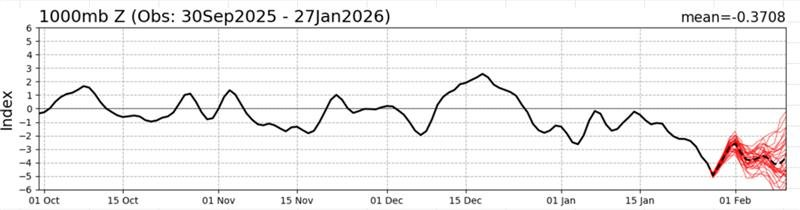
Meteorologists watching the larger-scale patterns could see it developing days in advance, as the Arctic Oscillation shifted deeper into its negative phase. As this happened, the jet stream, which usually moves in a steady, straight path, began to weaken and dip farther south in larger, more pronounced waves. This shift allowed a large mass of Arctic air to break away and move southward into the Midwest, setting the stage for a much more significant event than a typical cold spell.
By the time the first alerts appeared, the most important part of the story had already happened.
How Arctic Air Moves South During a Negative AO Phase
Once the Arctic air reached the Midwest, it didn’t arrive at once; it settled in, spreading outward and pressing south, gradually reshaping the entire region.
You could feel the divide forming.
To the north, temperatures dropped sharply into sub-zero territory as the cold air deepened. To the south, conditions remained closer to seasonal norms, at least temporarily. Between them, a narrow but powerful zone of contrast began to tighten, and that’s where the atmosphere started to respond.
This shift traced directly back to the Arctic Oscillation. Its strong, negative phase allowed an unusually large and dense Arctic air mass to move south, and that size mattered. Combined with available moisture, it created a sharp temperature gradient capable of fueling storm development.
Storms don’t just appear, they build from imbalance.
In this case, that growing contrast became the energy source for a low-pressure system that didn’t just pass through, but organized and strengthened, maintaining intensity as long as the imbalance remained.
How Local Conditions and Weather Stations Shape Winter Storm Impacts
From a distance, the setup looked straightforward, but on the ground, it rarely unfolds that cleanly.
As the storm developed, local conditions began to vary in ways that only surface observations could fully capture. In some valleys, cold air became trapped near the surface even as warmer air moved in above it, creating a layered environment where precipitation fell as freezing rain instead of snow. Nearby higher elevations saw entirely different outcomes.
At the same time, wind patterns varied just as dramatically. In areas where terrain created natural funnels, R.M. Young Wind Monitors deployed on Western Weather Group weather stations captured localized “gap wind” events: strong, accelerated flows that larger-scale models often smooth out or miss entirely. These micro-scale wind patterns can have outsized impacts on infrastructure, especially when combined with ice or heavy snow.
Near the Great Lakes, the interaction between the Arctic air mass and relatively warmer water enhanced snowfall rates, while in other regions, sharp temperature differences led to dramatically different outcomes over short distances.
These are the moments where weather station networks become essential, not just confirming conditions, but revealing the details that forecasts alone can’t resolve.
What Makes Winter Storms Last Longer and Stay Stronger
What made this storm stand out wasn’t just its intensity, but its persistence.
The Arctic air mass behind it was both extensive and deeply entrenched, effectively anchoring the pattern in place and preventing the system from weakening as it normally might. At the same time, the sharp temperature contrast between the sub-zero air to the north and milder air to the south continued to act as a steady source of energy.
As long as that gradient held, the storm had fuel, and with fuel, it became an anomaly: longer-lasting, more powerful, and far more disruptive than any typical winter system.
How Early Arctic Oscillation Signals Improve Winter Storm Preparedness
Events like this aren’t just notable for how they unfold; it’s how early they can be detected.
The Arctic Oscillation can begin signaling these types of pattern shifts up to two weeks in advance, well before traditional forecasts begin to lose reliability beyond the 7-day window. That early signal creates a critical buffer: time to assess risk, prepare resources, and anticipate how a developing setup may interact with specific locations.
For organizations with access to historical weather data and asset-level observations, that lead time becomes even more valuable. Patterns can be compared to past events, microclimates can be accounted for, and potential impacts can be anticipated before thresholds are reached in real time.
Connecting Large-Scale Weather Patterns to Local Impacts
Storms like this don’t exist on just one scale.
They begin with large-scale atmospheric signals like the Arctic Oscillation, but their true impact is shaped at the local level, including terrain, boundary layer effects, and microclimates that determine how temperature, wind, and precipitation behave on the ground.
Bringing those together is what closes the gap between knowing a storm is coming and understanding what it will actually do.
Watch: How Weather Stations and Large-Scale Patterns Work Together
If you want to better understand how patterns like the Arctic Oscillation drive storms like this, and how real-time observations from weather stations and wind monitors reveal what’s really happening at the surface, watch a clip from our recent RM Young and Western Weather Group webinar.
It breaks down how large-scale signals and local measurements work together during large scale events like this, and why that connection is critical for making better decisions before and during a storm or other major environmental events.