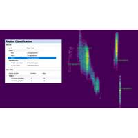
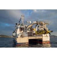
DeepOcean, Woodside Wrap Up Dual-Scope Subsea Survey at Sangomar Field
collected.The work used remotely operated vehicles equipped with scanning systems and software to generate digital 3D models of subsea assets using photogrammetry techniques.The complete package consisted of inspection engineers, ROV pilots, ROVs equipped with specialized scanning equipment, data processing software that enables use of computer-aided drawings (CAD), ROV footage and sonar, digital twin, and proprietary subsea 3D Imaging software that converts the data to real 3D Models.Operated by Woodside, Sangomar deepwater oil field is located about 100 km south of Dakar. It started production in
Ocean Geophysics Teams Up for EdgeTech on Seabed Data Processing
Offshore energy industry suppliers Ocean Geophysics has partnered with EdgeTech, a specialist in underwater technology solutions, to deliver advanced data processing software for EdgeTech’s newly launched eBOSS (Enhanced Buried Object Scanning System).The collaboration, established as a non-exclusive partnership, combines EdgeTech’s decades of hardware innovation with Ocean Geophysics’ expertise in geophysical data processing and interpretation.The result is a purpose-built software platform capable of processing, visualizing, and reporting data acquired by the eBOSS system with
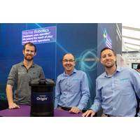
Sonardyne, Echoview Software Collaborate to Enhance ADCPs
organisms, fish shoals and physical processes such as internal waves and sediment plumes. When combined with the ADCP's water velocity measurements, users gain unprecedented insight into the complete marine environment from a single instrument.Echoview is an advanced echosounder and sonar data processing software, offering capabilities that range from easy data visualization to sophisticated target detection and analysis. Echoview Software and Sonardyne have worked closely together to ensure that Origin ADCP users can begin processing their echosounder data with Echoview from day one.The Origin ADCP
Echoview 15 for Hydroacoustic Data Analysis
Echoview Software launched Echoview 15, an update of its flagship data processing software designed for water column research.Echoview is designed to convert raw measurements from a wide range of echosounders and sonars into meaningful metrics. “This release provides users with powerful new tools which continue to advance the study and understanding of underwater ecosystems,” said Brett Merritt, CEO of Echoview Software.“Echoview 15 brings exciting new features that further simplify complex workflows and support advanced research applications," added Briony Hutton, Chief Scientist
iXblue SAS for Ifremer's new 6000m-rated AUV
to the scientific mission: physical parameters, chemical analysis, magnetometry, etc. Sams-150 has been selected based on its specifications for integration and use on the UlyX AUV: size, survey parameters such as altitude, resolution and swath. The unprecedented performance of the sonar and the data processing software chain are real assets. By combining imagery and bathymetry, the data from the Sams-150 sea trials show a significant potential that will bring scientific exploration to a whole new level.&rdquo
Shearwater GeoServices Bags Gambia 3D Gig
The provider of 3D marine seismic data, imaging products, and data processing software solutions, Shearwater Geoservices has been awarded a 3D Isometrix seismic acquisition project by FAR Gambia Ltd (FAR).According to a press release from the 50/50 joint venture between GC Rieber Shipping ASA and Rasmussengruppen AS, The one-month survey will cover parts of block A5 offshore Gambia in the rapidly emerging and prolific Mauritania, Senegal, Gambia, Guinea-Bissau, Conakry (MSGBC) Basin.The offshore survey service provider will be acquired by the SW Amundsen and provide new seismic over a shallow-wate
Swathe Services Takes Over as HYPACK Distributor
Swathe Services will take on responsibility for sales and maintenance of HYPACK software solutions in the U.K. and Ireland following the closure of HYPACK’s U.K. partner Del Norte Technology.U.S. company HYPACK – A Xylem Brand is a supplier of hydrographic survey and data processing software for single beam, multibeam, side scan sonar and many other applications in the hydrographic survey and dredging industries.Swathe Services, the Cornwall, U.K. based hydrographic survey services company specializing in Multi-Beam Echo Sounder (MBES) surveying, takes over HYPACK distributor
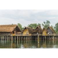
University of Vienna Acquires New Multibeam Equipment
is to create 3D model areas of former – now completely sub-merged - pile dwellings in Austrian lakes in order to document how some of our ancestors lived 5,000 years ago. The scope of supply features a Teledyne SeaBat T50-P multibeam sonar, data acquisition software QPS QINSy, data processing software (BeamworX AutoClean/AutoPatch and QPS Fledermaus), training, and installation. Also supplied was the GNSS System Septentrio AsteRx-U UHF in combination with an ALTUS NR2 base station and the INS Sensor SBG Apogee-E to get a high precise position. To guarantee a reliable and
Atlantic Canada Profiles: Rutter
;s sigma S6 product line, which also includes systems focused on oil spill detection, small target surveillance and wave and current measurement, connect to commercial marine radars, adding value to those existing navigation assets. “With the release of our latest generation of marine radar data processing software, sigma S6 9.1.0, we are able to assist vessels to improve their operations and fulfill industry demands with even greater efficiency,” said Fraser Edison, President and CEO, Rutter. Stephen Hale, Director of Sales & Marketing at Rutter, added, “Whether used in combination