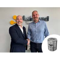
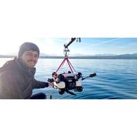
Ashtead Technology Orders Teledyne’s New Autonomous Navigation System
, the company’s new ultra-compact autonomous navigation system for subsea and surface vehicles.Ashtead Technology has placed a significant initial order, marking the first commercial adoption of what is said to be the world’s smallest and highest-performing, fully integrated autonomous navigation solution.The Compact Navigator is Teledyne Marine’s latest advancement in navigation technology, designed to deliver high-precision positioning and enhanced performance in a lightweight, ultra small form factor. The system is suitable for small vehicles, it enables new inspection and survey
Ocean Business: Teledyne Marine Introduces New Technologies and Solutions
to Stand T7 and Dockside HS 02 can experience firsthand the latest advancements in marine navigation, acoustics, and sensing technology, including the exclusive launch of the Compact Navigator.Compact Navigator – the world’s smallest and highest performing, fully integrated autonomous navigation solution is revealed at Ocean BusinessSeaBat T51-S – the enhanced SeaBat T51 now reaches 6000m depth while ensuring reliable, hands-free operationWorkhorse Proteus – an evolution of the original Workhorse ADCP combines ultimate flexibility and unparalleled dataBlueStreamX2
Klein Marine Systems Selects Exail Navigation Technology For Sonar
Klein Marine Systems, a leader in sonar technology, has selected the Exail Octans Nano OEM Attitude and Heading Reference System (AHRS) as the standard navigation solution for their 5900 Side Scan Sonar (SSS). This collaboration aims to enhance the sonar’s precision and reliability for high-resolution seabed mapping, supporting a range of defense, security, and commercial applications.The Exail Octans Nano OEM AHRS offers a heading accuracy of 0.5° secant latitude, and pitch and roll accuracy of 0.1°, ensuring stable and precise attitude and heading data. These capabilities are essential
Greensea IQ Contract to Further Develop USN Autonomous Vehicle
and Automatic Target Recognition (ATR) components. This contract extension signifies a closer step to providing this enabling technology to U.S. Navy EOD Technicians.IQNS provides an NVIDIA edge processor, integrated fiber optic gyro, aiding navigation sensors, and Greensea’s patented navigation solution for small underwater robots. IQNS is designed as an upgrade solution for systems currently running Greensea’s defense software suite and is used throughout Greensea’s own robot product line. Greensea is augmenting IQNS for this program with advanced autonomy capabilities

Less is More with Gyroscopes
;s sensor fusion algorithm is more sophisticated than Kalman filters. Kalman filtering provides estimates for unknown variables that are primarily statistics-based. The sensor fusion approach is more accurate at determining and removing sensor errors, which results in a higher performance navigation solution.The technologies that have been developed for the DFOG include digital modulation techniques that allow in-run variable errors in the coil to be measured and removed from the measurements. The “learning” capabilities of the AI enable it to accumulate sensor error data and associated
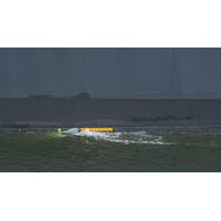
Tethys Robotic's new ROV Leverages Nortek DVL Tech
A new Remotely Operated Vehicle (ROV) from Switzerland’s Tethys Robotics is aiming to provide a safer alternative to putting divers in the water, utilizing Nortek DVL to complete its navigation solution.Jonas Wüst, CEO at Tethys Robotics, set out to meet these challenges of working efficiently, safely underwater following a student research project at Eidgenössische Technische Hochschule Zürich (ETH Zurich), a public university in Switzerland. Tethys Robotics’ goal was to build an autonomous underwater robot capable of being deployed in rough water with currents of up to 2
Armach's Hull Service Robot Excels in Over-the-horizon Operation Trials
side of the ship. Once there, it was able to attach itself successfully, and travel along the ship's side, performing a short test cleaning protocol.“Peyres adds: "We continue to leverage Greensea's OPENSEA open architecture control software, fused with Armach’s On-Hull navigation solution from the HSR's [Hull Service Robot's] myriad sensors, providing rock-solid vehicle control. "We also knew that Greensea’s Safe C2, a distance operation solution also part of the OPENSEA suite, had already proved that it was operationally viable for conducting advanced
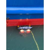
Armach Robotics Set to Take the Pole Position on Ship Hull Maintenance, Intelligence
and where are we today?Greensea Systems is a software company, well-known for our software platform on ocean robotics. We're also well-known for our unique navigation and autonomy solutions. A few years ago we started a program with the Office of Naval Research (ONR) developing a very accurate navigation solution for robots transiting on a ship hull for the purposes of proactive in-water cleaning the hulls. ONR was a pioneer in the development of proactive in-water grooming of ship hulls back in the early to mid-2000s.This requires the insurance of a 100% coverage of the hulls, and to be really effective
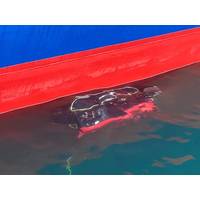
Greensea Launches Hull Cleaning Spin-off Armach Robotics
the hull, and 100% coverage can be assured, the company said.Rob Howard, VP Growth and Strategy at Armach Robotics, said, “Hull drag is time and money in the shipping business. The system we have devised represents the closest any company has got to fully autonomous hull cleaning. With our navigation solution, the robot’s route across the hull is optimized to within inches ensuring no areas are missed or over cleaned, so we can be efficient and fast in performing our service.”Armach said it leverages Greensea’s proven navigation systems to ensure that the robot cleans the hull


