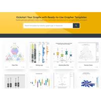
Golden Software Makes Upgrades Grapher Scientific Package with Enhanced Templates
allows for customization. Custom templates can be saved for repeated use, and long-time Grapher users can revert to the same workflows used in the past to re-create, update, and modify existing projects.The Golden GalleryGrapher users may choose from over 30 Templates available either inside the software package or online via the Golden Gallery. Users can browse the Gallery to find the Template that visually presents their data most favorably or to receive recommendations on which graphs are best for specific industries, applications, or data types. Users even get tips on structuring their data sets
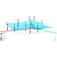
Golden Software Expands 3D Drillhole Visualization, Overall Usability in Surfer Mapping Package
Golden Software has continued to enhance the 3D drillhole viewing functionality in the latest release of its Surfer mapping and 3D visualization software package. Overall, the new version of Surfer provides users with several upgrades to save time and streamline creation of subsurface maps.Surfer is used by more than 100,000 people worldwide, many involved in environmental consulting, water resources, engineering, mining, oil & gas exploration, and geospatial projects. Surfer enables users to model data sets, apply an array of advanced analytics tools, and visually communicate the results in a way
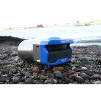
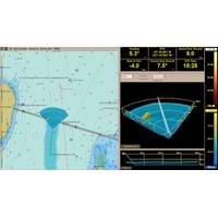
Tritech Launches New Gemini Sonar
of waterborne electrical noise for optimal imaging performance.An integrated speed-of-sound sensor ensures that targets are displayed to a high degree of positional accuracy. CHIRP processing provides improved target separation over longer ranges.The 1200id is fully compatible with Tritech’s software package, Genesis. This ensures improved user interaction and allows for control of multiple Tritech products from within one software package. Software development kits (SDKs) are also available for Windows and Linux operating systems“With its ultra-low-noise differential analogue front-end supporting
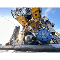
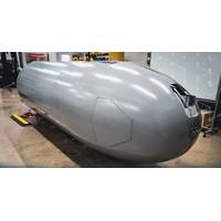
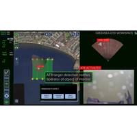
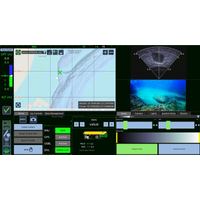
Greensea IQ Contract to Further Develop USN Autonomous Vehicle
Edge, will provide a robust solution for underwater EOD tasks. The integration of sonar-based target classification and operator assist autonomy enables more accurate threat detection and neutralization.The technologies productized under this program will bring upgrades to Greensea’s EOD Edge software package, the edge processing solution for EOD Workspace, and an integrated solution with navigation and processing through IQNS. A lighter weight deployment through IQNS Mini will also be available. IQNS with EOD Edge will be available in Q4 2024 on Greensea’s Bayonet product line
OET Testing New ROV Cameras for 3D Model Making
;1 centimeter) visual and acoustic data over the seafloor using a new widefield camera array system and Norbit wideband multibeam sonar. The widefield camera array was co-developed by the Ocean Exploration Trust and Sexton Corporation with funding from the Office of Naval Research (ONR). A customized software package for the Norbit sonar was recently developed by Corps of Exploration Navigator Dr. Kristopher Krasnosky, which takes raw data collected by sonar and allows onboard teams to visualize it in real-time.High-resolution visual and acoustic data collected by the ROV-mounted sensors will be used to
Nauticus Robotics Bags $2.7 Million Contract Extension from Leidos
platform, Aquanaut, this derivative robot features technology to support security activities and is advancing to complete longer and more challenging missions. In addition, this award allows further autonomous behavior and operational capability enhancements to toolKITT, Nauticus' proprietary software package developed to enable an ecosystem of autonomous actions for subsea vehicles and serves as the foundation for this work."I am very proud of our team's performance resulting in this follow on award, further cementing our partnership with Leidos," said Nicolaus Radford, founder and
Greensea Launches OPENSEA Edge
and video perception feeds while providing autonomy, communications, and task management for the robot. This platform puts a tremendous amount of processing power at the edge, right on the robot, where it can work directly with sensor data and make decisions for the vehicle. OPENSEA’s Safe C2 software package for low bandwidth and high latency communications links provides a seafloor to over-the-horizon communications solution for operators supervising the robot. With the open architecture framework of OPENSEA and available processing space, developers can install their own autonomy and perception-handlin
Greensea Announces Software Upgrades, VideoRay Partnership
Technician. Workspace and Professional Workspace have been upgraded to version 5.0.All standard software on VideoRay’s Mission Specialist Series ROVs was updated earlier this month.Founder and CEO of Greensea Systems Inc. Ben Kinnaman commented, “OPENSEA with Workspace is the standard software package on VideoRay’s Defender and Pro5 vehicles. OPENSEA provides the capability to perform advanced autonomous missions and prepares these vehicles for future technology advances as an open architecture platform. The newest versions of Workspace are the result of a direct collaboration with
FarSounder, Navtor Partner
FarSounder and Navtor announces a new partnership, with FarSounder now including support for NAVTOR official ENC chart data in itsbase software package.Navtor is centered on creating e-Navigation tools that are safe, simple and efficient. Similarly, FarSounder’s Argos 3D Forward Looking Sonar is designed to provide safe navigation by detecting many ocean obstacles via an easy-to-understand user interface. According to the pair, this partnership will bring an impactful software update for Argos technology."By implementing the NavtorECDIS Kernel in the FarSounder platform, we bring official


