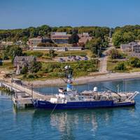
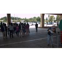
Retiring the R/V Endeavor: Celebrating a Lifetime of Accomplishments and Memories
;s been huge advances in satellite communications and cybersecurity, and we're a leader in that regard," Gruebel added.New era, new DawnAs Endeavor heads into retirement, URI is planning for its new vessel, R/V Narragansett Dawn, which at time of writing is under construction in Houma, Louisiana, and will be delivered in March 2026. By design, this latest vessel will feature new capabilities and technologies."From the operational side, one of the biggest requests that a lot of the scientists seem to have in the fleet is for dynamic positioning systems," said Thornton. "That

HII USV Reaches 30% Completion, On Track for 2026 Sea Trials
HII executives toured Breaux Brothers Enterprises in Loreauville, Louisiana, and announced that construction of a prototype of ROMULUS, the company’s new unmanned surface vessel (USV) family, has reached 30% completion. The vessel remains on schedule for sea trials in the fourth quarter of 2026.During the visit, HII leaders toured the shipyard with build partners Breaux Brothers and Incat Crowther, and reviewed progress on hull construction, integration of the HII’s Odyssey Autonomous Control System (ACS), and outfitting work.ROMULUS USVs are designed to meet the current and emerging
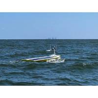
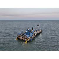
USV Provides Near Real-Time Deep Ocean Current Observations
current profilers (ADCPs) and SeaTrac’s SP-48 USV to gather near-real-time current profile data from the Loop Current System.Over 18 months, four Origin 65s and five pressure inverted echosounders were deployed in 1,800 to 3,200 m water depth, in the heart of the LCS, 200 nm off the coast of Louisiana. Origin 65 is a 4,100 m-rated, low frequency, deepwater profiling ADCP. It can profile up to 800 m range in time-aligned, high resolution and also comes with pressure inverted echo sounder (PIES) functionality. With the Origin 65’s integrated Edge processing capability and acoustic
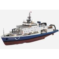
NOAA to Hold Keel-Laying Ceremony for New Charting, Mapping Vessel
NOAA Marine and Aviation Operations will celebrate the keel-laying for Navigator, the second of two new charting and mapping vessels being constructed for NOAA. The vessel is being built by Thoma-Sea Marine Constructors, LLC., in Houma, Louisiana.The keel-laying is a centuries-old maritime tradition that formally recognizes the start of a ship's construction. During the ceremony, the initials of the ship’s sponsor will be welded onto a steel plate that will be incorporated into the ship during construction.BackgroundNOAA is adding two new charting and mapping vessels to the NOAA fleet:

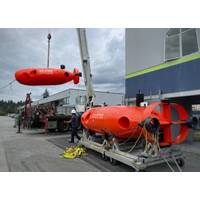
Nauticus Robotics Pushes Aquanaut Mark 2 Deeper
Nauticus Robotics has announced that its flagship underwater vehicle, Aquanaut Mark 2, has reached a new depth record of 2,300 meters underwater, 240 kilometers off the coast of Louisiana.Aquanaut is a fully electric-operated autonomous underwater vehicle, currently under testing, that images subsea structures, such as manifolds, trees and pipelines, and is capable of performing seabed scanning, leak detection, obstacle avoidance, and close visual inspection. These vehicles are untethered, which eliminates the need for topside structures and makes the project significantly more efficient and safer for
Keel Laid for NOAA Charting and Mapping Vessel
A keel-laying ceremony has been held for Surveyor, a new charting and mapping vessel being constructed for NOAA by Thoma-Sea Marine Constructors, LLC., in Houma, Louisiana.In 2023, NOAA announced two new charting and mapping vessels would be added to its fleet. Surveyor is expected to be completed in 2027 and Navigator in 2028. The ships will be used primarily for ocean mapping and nautical charting as part of NOAA’s mission to deliver tools and information to help mariners safely navigate the nation’s ports and harbors.The name Surveyor points to one of NOAA’s key missions —
Nexans, Crowley Wind Services to Build Cable Lay Barge for US Ops
to develop and operate a Jones Act compliant cable lay barge. The cable lay barge will be dedicated to supporting the installation of subsea transmission lines necessary for offshore wind energy, telecommunications and other major industrial applications.The 300-foot, U.S.-flagged vessel, built in Louisiana and tested in the U.S. Gulf to Nexans specifications, will be crewed by American mariners under Crowley’s operation.The vessel will play a critical role in laying and burying the subsea cables needed to deliver energy from offshore to the grid onshore. The barge is the first to have vertical

NOAA, Partners to Announce Findings From 2025 Gulf of America "Dead Zone" Monitoring
year’s zone size, potential impacts to living marine resources, the accuracy of the spring hypoxia forecast, and ongoing federal and state initiatives in the Mississippi River watershed focused on reducing nutrient runoff into the Gulf.Speakers will include:Cassandra Glaspie, Associate Professor, Louisiana State University; Chief scientist of survey cruiseSean Corson, Director, NOAA’s National Centers for Coastal Ocean ScienceGretchen Oelsner, Hydrologist, Water Mission Area, U.S. Geological SurveyTBD, Environmental Protection AgencyMike Naig, Secretary of Agriculture, State of IowaMeeting
Nauticus Robotics Marks a Year of Transformation
legacy customers are welcoming this combined offering of a vessel with both an Aquanaut vehicle and an ROV onboard.By installing ToolKITT on both vehicles, the first subsea robotic collaboration solution will be realized, and customers should see the immediate value. SeaTrepid's location in Robert, Louisiana provides a testing facility with closer proximity to the launching location for offshore Gulf Coast operations, improving logistics and reducing costs.In Q1 2025 the company conducted At The Market offerings, in which it issued and sold almost 7.5 million shares for net proceeds of $19.4 million