Marine Technology News Search
Search term • "advanced navigation"
Create an email alert for "advanced navigation"
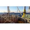
Hellenic Cables, Asso.subsea Get Dunkerque Offshore Wind Farm’s Cabling Job
Hellenic Cables and Asso.subsea have secured a turnkey contract by Réseau de Transport d’ Électricité (RTE) to supply and install export cables for the Dunkerque offshore wind farm.The Dunkerque offshore wind farm, with a planned capacity between 500 and 600 MW, will feature two 225kV HVAC export cable links which will enable the seamless transfer of clean energy to the French grid.Hellenic Cables will design…
NOAA Determines TMC USA’s Seabed Mining Application is in Substantial Compliance
NOAA has determined that the consolidated application submitted by The Metals Company USA (TMC USA) for an exploration license and commercial recovery permit under the Deep Seabed Hard Mineral Resources Act (DSHMRA) is in substantial compliance with the requirements of the Act and its implementing regulations.Earlier this year, TMC USA submitted a consolidated application for an exploration license…
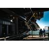
Teledyne Marine Unveils Multiple New Product launches at Ocean Business
Meet Teledyne Marine at stand no T7 and for dockside demos at HS 02Ocean Business (National Oceanography Centre in Southampton, UK, from April 8–10, 2025) is the launch venue for an exciting range of brand new products from Teledyne Marine. Visitors to Teledyne Marine’s stands in the exhibition hall and dockside will have the opportunity to explore its newest product launches and trusted industry solutions…
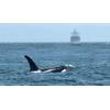
Ocean Wise, Trelleborg Advance Whale Protection Through Global Navigation Software Integration
Ocean Wise and Trelleborg Marine and Infrastructure announced an advancement in marine mammal protection through the international expansion of Ocean Wise’s Whale Report Alert System (WRAS), a real-time alerting tool designed to reduce the risk of ship strikes on whales. This expansion includes a new integration with Trelleborg’s SafePilot Pro software, a professional-grade navigation system used by marine pilots globally.The WRAS…

50 Years of Women in Navy Diving: Advancing Opportunity in Tandem with Technology
By Captain Bobbie Scolley, U.S. Navy (ret.) and Rear Admiral Tim Gallaudet, U.S. Navy (ret.)For more than six decades, spanning from 1905 to the late 1970s, the U.S. Navy’s diving apparatus for deep ocean operations and salvage remained fundamentally unchanged. During this period, the demographic of navy divers also saw little alteration. However, beginning in the mid-1970s and continuing to the present day…
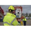
OEG Unveils Geometry Assurance Software for Ships and Subsea Vessels
OEG Energy Group (OEG) has officially unveiled GEOBASE, an offshore industry’s first dedicated vessel dimensional control assurance solution for survey and positioning systems onboard ships and subsea vehicles to feature calibration software.It has been developed as a database to help document survey vessel geometry and standardize the measurement of vessel dimensions, sensor placements, and reference points.Alongside this…

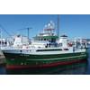
Seaspan Delivers Canadian Coast Guard Research Vessel
Seaspan Shipyards has officially delivered the Offshore Oceanographic Science Vessel (OOSV), CCGS Naalak Nappaaluk, to the Canadian Coast Guard (CCG).The OOSV is the fourth large vessel, and second class of ship, to be built and delivered by Seaspan under the National Shipbuilding Strategy (NSS).CCGS Naalak Nappaaluk is named after a well-respected elder from Nunavik who was a renowned promoter of Inuit language and culture.The ship will replace CCGS Hudson…
Shearwater to Buy Schlumberger’s Seismic Business
Norwegian marine geophysical services company Shearwater GeoServices Holding AS has entered into a definitive agreement to acquire the marine seismic acquisition assets and operations of Schlumberger’s geophysical services product line, WesternGeco.The transaction, which remains subject to regulatory approvals and other customary closing conditions, is expected to close in the fourth quarter of 2018.Houston…
Ashtead Technology Acquires Welaptega
Subsea equipment solutions specialist Ashtead Technology said it has bolstered its inspection, maintenance and repair (IMR) services and capabilities with the acquisition of Canadian-based underwater inspection company Welaptega.The transaction comes 10 months after the company completed a joint venture with Forum Energy Technologies, creating an independent provider of subsea survey and ROV equipment services with a fleet of 19…
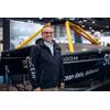
Shep Smith Appointed XOCEAN CTO
XOCEAN appointed Shepard "Shep" Smith as Chief Technology Officer (CTO) in the latest expansion of its leadership team. Smith served 28 years as a commissioned officer with the U.S. Department of Commerce National Oceanic and Atmospheric Administration (NOAA). At NOAA, Smith rose to the rank of Rear Admiral and was closely involved in advancing state-of-the-art hydrography and nautical cartography.His 10 years of working at sea included tours in Alaska…
L3 OceanServer Expands
L3 OceanServer, a developer and manufacturer of autonomous underwater vehicles (AUVs), has recently added 4,700 square feet of space at its headquarters location in Fall River, Mass. This doubles the operational footprint of the business and will accommodate the company’s rapid growth while continuing to leverage its waterfront location for daily vehicle testing and operations. Additionally, a 46-foot research vessel…
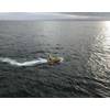
Autonomous Vehicle Maps the Arctic Seafloor
Far above the Arctic Circle, an autonomous surface vehicle set out to map the seafloor in an effort to improve nautical charts in areas where there is scarce data and vessel traffic is increasing.A team of engineers and students from the University of New Hampshire’s (UNH) Center for Coastal and Ocean Mapping, together with personnel from NOAA’s Office of Coast Survey, recently returned from an Arctic…
High-End Seismic Imaging Solves Shallow Gas Challenges
The latest Q modeling, and Q-compensating imaging techniques bring greater clarity to Northern Viking GrabenCGG has recently completed seismic depth imaging of its entire Northern Viking Graben multi-client survey, in the Norwegian North Sea. The latest visco-acoustic (“Q”) velocity modeling and seismic imaging technologies have been applied to BroadSeis broadband variable-depth streamer field data, acquired between 2014 and 2016.
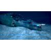
Inmarsat's Satellite Services for OceanGate Expeditions' 2022 Titanic Survey Expedition
OceanGate Expeditions has announced Inmarsat as the satellite service provider for the 2022 Titanic Survey Expedition. Inmarsat’s Fleet Xpress high-speed satellite service will enable OceanGate Expeditions’ at-sea crew to instantly connect with scientific and operational resources anywhere in the world and to share important findings immediately while enhancing safety for the entire operation. Following the tragic loss of life in the sinking of Titanic…
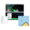
Teledyne CARIS Unveils Bathy DataBASE 5.2
Teledyne CARIS has released Bathy DataBASE 5.2, which introduces enhanced tools for validating and creating chart features from lidar surveys as well as new bathymetry compilation techniques.This latest version includes an updated workflow process found in BASE Editor designed for performing both quality control and feature set building from lidar data. Bring LAS/LAZ data into the BASE Editor environment to assess quality, adjust classification, and compare against other sources.
Ireland’s New Research Vessel Arrives in Galway
Ireland's new research vessel, the RV Tom Crean, has arrived in Irish waters and is currently docked in the Port of Galway before embarking on its first survey towards the end of July and then making its way to Dingle in advance of its official commissioning due to take place in Autumn 2022. The vessel has been named the RV Tom Crean after the renowned seaman and explorer from Kerry, who undertook…
Kongsberg Maritime's Sonar and Navigation Package for Norwegian and German Navies' Type 212CD Subs
Kongsberg Maritime's active sonar suite and bottom navigation technology has been selected for installation on Type 212CD class submarines for both the Norwegian and German navies.The contract was awarded through a comparative and thorough process governed by Kongsberg Thyssen Atlas JV (kta naval systems) and tkMS (thyssenKrupp marine systems) with another vendor(s).The Kongsberg technology package…
Gazelle Wind Power Appoints CTO
Irish floating wind platform firm Gazelle Wind Power has appointed Jason Wormald, former Global Head of Innovation of Bridon-Bekaert Ropes Group, as Chief Technology Officer to lead the company’s product design and engineering."In order to realize the full potential of offshore wind and drive down costs, we have taken a different approach to the platform design, and there is nobody better to drive this technological vision than Jason,” said Gazelle CEO Jon Salazar.
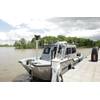
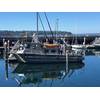
USACE Mobile District Adds New Survey Vessel
The U.S. Army Corps of Engineers, Mobile District and Tennessee-Tombigbee Waterway Development Authority held a ceremony to officially welcome a new survey vessel to its fleet in Columbus, Miss., April 28, 2023.The Miss Agnes, built by Theodore, Ala. based Silver Ships, is a custom 26-foot multibeam and single beam capable marine survey vessel that features an enclosed center console, a three-monitor survey station, and an air conditioner unit that is paired with a generator.
Tech Spotlight: JW Fisher’s CT-1 Cable Tracker
What options exist when safe mission execution depends upon the identification and tracking of important power or communication cables? Both on land and submersed, the location and mitigation of important cables is an essential step in any construction or salvage project. JW Fishers Mfg. has the tool for the job; the CT-1 Cable Tracker, specifically designed to locate and track buried power and communication cables…


