Sea Level Rise Tool for Superstorm Sandy Recovery
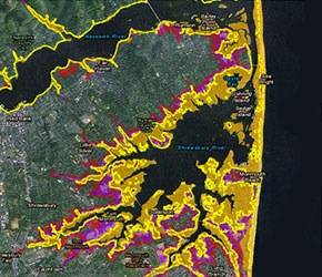
Flood prediction map: Image credit NOAA
NOAA, in partnership with FEMA and the U.S. Army Corps of Engineers, has created a set of map services to help communities, residents, and other stakeholders consider risks from future sea level rise in planning for reconstruction following Hurricane Sandy, including:
- A NOAA-led interagency report prepared as input to the National Climate Assessment, Global Sea Level Rise Scenarios for the United States National Climate Assessment . Scientists from multiple federal agencies and academic institutions synthesized the best available science to create a set of scenarios of global mean sea level rise through 2100. This team considered both ocean warming and melting of mountain glaciers and ice sheets. For all areas in NJ and NY outside the five boroughs, the maps use these global scenarios combined with the best available FEMA flood hazard data.
- These map products display what the future 100-year floodplain boundaries could look like with sea level rise.
- The 2013 New York City Panel on Climate Change report, Climate Risk Information 2013: Observations, Climate Change Projections, and Maps . Experts convened by Mayor Michael Bloomberg’s Office of Long Term Planning and Sustainability developed regional sea level rise scenarios for the five boroughs in New York City out to 2050. These scenarios include sea level rise from both ocean warming and ice sheet melt, and factor in local conditions such as vertical land movement and regional climate variations. For all areas inside the five boroughs of NYC, the maps use these scenarios combined with the best available FEMA flood hazard data.
The U.S. Army Corps of Engineers, in partnership with FEMA and NOAA, has modified its existing Sea-Level Change Calculator to integrate FEMA’s best available elevation data with the same two peer-reviewed sources of information on future sea level rise used in the NOAA maps and described above.
Full details are available at: http://globalchange.gov/what-we-do/assessment/coastal-resilience-resources