-
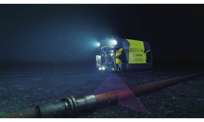
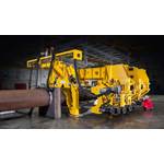
Saipem’s Hydrone-R Marks Subsea Milestone at Equinor’s Njord Field
Saipem’s underwater intervention drone Hydrone-R, currently operating on Equinor's…
-
Aker BP Opts for Optime Subsea’s ROCS
Norwegian subsea technology company Optime Subsea has been awarded a contract by…
-
Sea Drone Warfare has Arrived, and the US is Floundering
The U.S. Navy's efforts to build a fleet of unmanned vessels are faltering because…
-
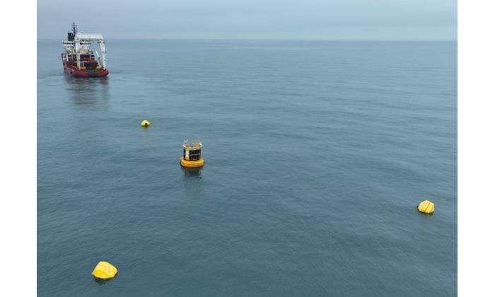
TGS Launches Multi-Client Wind and Metocean Surveys Off Germany
Norwegian seismic firm TGS has started its latest multi-client wind measurement campaign…
-
Kraken Robotics Scoops Multi-Million-Dollar Orders for Subsea Security Equipment
Canadian marine technology company Kraken Robotics has received orders for its subsea…


Latest news
-
OceanAlpha Delivers Research USV to Hong Kong University
OceanAlpha delivered a L12E USV, dubbed The Clear Water Bay, to Hong Kong University of Science and Technology (HKUST), to…
-
Mermaid Gets Subsea Services Contract Extension in Middle East
Mermaid Maritime has, through its joint venture company with GCC, secured a one-year contract extension for subsea services…
-
James Fisher Wraps Up Decommissioning Work Offshore Thailand
James Fisher Decommissioning, part of James Fisher and Sons, has completed offshore decommissioning operations in the Gulf…
-
Hollandse Kust West Beta Export Cables to Come Ashore Next Week
The first export cable for the Hollandse Kust West Beta offshore wind farm will come ashore next week as the work progresses…
Offshore Energy
-
Odfjell Technology Boosts Asia Pacific Presence with New Contracts in Malaysia
Odfjell Technology, an integrated supplier of well services technology and engineering solutions, has been awarded three…
-
RWE Inks Deals for Three HVDC Offshore Wind Substations with Hitachi Energy and Aibel
German energy giant RWE has signed framework agreements with Hitachi Energy and Aibel for the joint supply of three high…
-
CGG and Baker Hughes Form CCS Alliance
French marine seismic firm CGG has signed a memorandum of understanding (MoU) with U.S. energy services giant Baker Hughes…
Hydrographic
-
Kraken Robotics Wins $11M of New Service Contracts
Canadian marine technology company Kraken Robotics has secured $11 million of new contracts since the start of the year.The…
-
Arctia to Map Offshore Wind Area in Norway
Arctia Meritaito, a subsidiary of Finland's Arctia, announced it has been awarded a contract by the Norwegian Mapping Authority…
-
NORBIT Boosts Hydrographic Support Capability in APAC
NORBIT welcomes onboard Tan Hean Chee, Jerry in the position of the Hydrographic Surveyor responsible for supporting APAC Partners and Clients.
Ocean News
-
Scientists Discover Possible Hammerhead Shark Nursery in Ecuador's Galapagos
A team of researchers has discovered a potential breeding ground for smooth hammerhead sharks off an island in Ecuador's Galapagos archipelago…
-
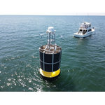
Wave Measurement Technology Helps Protect Vietnam’s Coastal Population
The Mekong Delta in Vietnam is home to over 20 million people and acts as a globally important agricultural area. The health…
-
OPT Wins Multi-year NOAA ProTech Oceans IDIQ Contract
Marine power, data, and service solutions provider Ocean Power Technologies, Inc. (OPT)vannounced its selection as part of…
Subsea Defense
-
UK Royal Navy Buys More Remus UUVs
HII, a manufacturer of underwater unmanned vehicles (UUV), announced the recent sale of three REMUS 100s and five REMUS 300s to the U.K.
-
Manta Ray UUV Prototype Completes In-water Testing
The Manta Ray prototype uncrewed underwater vehicle (UUV) built by Northrop Grumman completed full-scale, in-water testing…
-
US Navy Announces First Mine Countermeasures Mission Package Embarked on USS Canberra
The U.S. Navy embarked the first Mine Countermeasures Mission Package (MCM MP) aboard USS Canberra (LCS 30), April 18, service officials announced.
Vehicle News
-
Subsea Vessel Market is Full Steam Ahead
Since our last market update in the subsea space about a year ago both our current market view and forecasts have strengthened…
-
Greensea IQ and VideoRay Partner to Enhance ROV User Experience
Marine technology companies Greensea IQ and VideoRay announced they are expanding their partnership to enhance the user experience…
-
Sea Machines Launches Its First Turnkey USV
Boston-based Sea Machines Robotics has unveiled its first turnkey unmanned surface vessel (USV) dubbed Selkie.The first model…
New Products
-
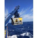
Optimizing Cathodic Protection Survey Using Non-contact Sensors
The principle behind sacrificial anodes, which are used to safeguard underwater pipelines and structures from corrosion,…
-
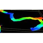
Kongsberg’s First HUGIN Endurance Passes Factory Acceptance Testing
Kongsberg Discovery has completed factory acceptance testing of its first long-range Autonomous Underwater Vehicle (AUV)…
-
Eelume Partners with Exail
Exail was selected by Eelume to supply its Phins Compact C3 Inertial Navigation System (INS) for Eelume's new S-Series all…